Property Record
5920 Johns Rd, Bessemer, AL 35023


NEARBY LISTINGS FOR SALE OR LEASE
-
-
View all Bessemer listings for sale on LoopNet.com
Property Detail
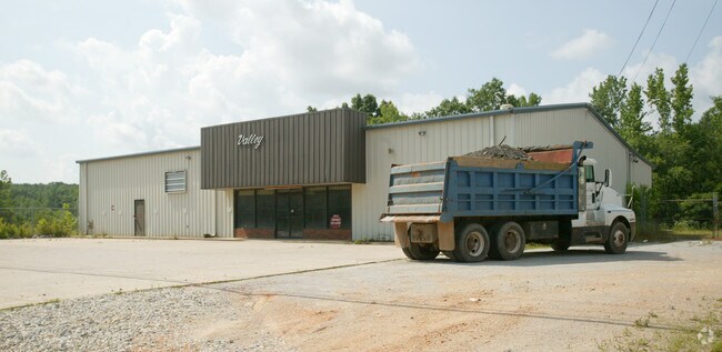
5920 Johns Rd
37-00-11-3-000-001.007
BEG AT NW COR OF SW4 OF SW4 OF SEC 11 TP 19S R 5W TH S 200 FT SE ALG R/W 565 FT TO POB CONT SE 245 FT TH SW 150 FT NW 100 FT WLY ALG OLD RD 181.4 FT NE 235 FT TO POB
Autorepair
Jefferson
X
Alabama
01073C0518G
1.03 AC
2023
Bessemer
2024
Birmingham
014002
Birmingham-Hoover, AL
6,000 SF
DEMOGRAPHICS near 5920 Johns Rd
1 Mile
3 Mile
5 Mile
2024 Total Population
420
4,875
35,926
2029 Population
410
4,746
35,235
Pop Growth 2024-2029
(2.38%)
(2.65%)
(1.92%)
Average Age
45
43
40
2024 Total Households
164
1,905
14,181
HH Growth 2024-2029
(1.83%)
(2.73%)
(2.06%)
Median Household Inc
$67,500
$65,391
$51,727
Avg Household Size
2.50
2.50
2.40
2024 Avg HH Vehicles
3.00
2.00
2.00
Median Home Value
$222,449
$217,278
$150,963
Median Year Built
1978
1978
1970
Nearby Places
Map Layers
Map Styles
 Street
 Aerial
- Restaurants
- Banks
- Shops
- Fitness
- Groceries
PUBLIC TRANSPORTATION
AIRPORT
Birmingham-Shuttlesworth International
DRIVE
WALK
Distance
Birmingham-Shuttlesworth International
35 min
24.7 mi
Nearby Properties
Address
Land Use
TOTAL SIZE
Lot Size
Zoning
Address
Land Use
TOTAL SIZE
Lot Size
Zoning
857,420 SF
34.50 AC
I3
Address
Land Use
TOTAL SIZE
Lot Size
Zoning
311,900 SF
30.20 AC
Address
Land Use
TOTAL SIZE
Lot Size
Zoning
38,868 SF
10.90 AC
C-4
Address
Land Use
TOTAL SIZE
Lot Size
Zoning
137,641 SF
26.80 AC
R4
Address
Land Use
TOTAL SIZE
Lot Size
Zoning
63.30 AC
I3
Address
Land Use
TOTAL SIZE
Lot Size
Zoning
2.50 AC
C4
Address
Land Use
TOTAL SIZE
Lot Size
Zoning
25,182 SF
1.76 AC
C4
Address
Land Use
TOTAL SIZE
Lot Size
Zoning
38,376 SF
4.87 AC
C3
Address
Land Use
TOTAL SIZE
Lot Size
Zoning
23,264 SF
4.06 AC
C4
Address
Land Use
TOTAL SIZE
Lot Size
Zoning
27,383 SF
7 AC
C4
Address
Land Use
TOTAL SIZE
Lot Size
Zoning
81,846 SF
77.30 AC
I3
Address
Land Use
TOTAL SIZE
Lot Size
Zoning
21,928 SF
5 AC
C4
Address
Land Use
TOTAL SIZE
Lot Size
Zoning
26,685 SF
1.71 AC
I3
Address
Land Use
TOTAL SIZE
Lot Size
Zoning
26,004 SF
2.38 AC
I3
Address
Land Use
TOTAL SIZE
Lot Size
Zoning
59,839 SF
9.70 AC
C4
Address
Land Use
TOTAL SIZE
Lot Size
Zoning
1.80 AC
C4
Address
Land Use
TOTAL SIZE
Lot Size
Zoning
26,434 SF
1.24 AC
C4
Address
Land Use
TOTAL SIZE
Lot Size
Zoning
21,491 SF
2 AC
I3
Address
Land Use
TOTAL SIZE
Lot Size
Zoning
72,600 SF
6.64 AC
I3
Address
Land Use
TOTAL SIZE
Lot Size
Zoning
44,316 SF
17 AC
I3
Address
Land Use
TOTAL SIZE
Lot Size
Zoning
110 AC
I3
Address
Land Use
TOTAL SIZE
Lot Size
Zoning
21,420 SF
2.08 AC
C4
Address
Land Use
TOTAL SIZE
Lot Size
Zoning
21,225 SF
1.76 AC
I3
Address
Land Use
TOTAL SIZE
Lot Size
Zoning
39,398 SF
3.41 AC
INST
Address
Land Use
TOTAL SIZE
Lot Size
Zoning
30,854 SF
21 AC
B1
Address
Land Use
TOTAL SIZE
Lot Size
Zoning
6,353 SF
1.30 AC
I3
Address
Land Use
TOTAL SIZE
Lot Size
Zoning
33,000 SF
2.89 AC
I3
Address
Land Use
TOTAL SIZE
Lot Size
Zoning
33,600 SF
6.80 AC
I4
Address
Land Use
TOTAL SIZE
Lot Size
Zoning
9,690 SF
2.53 AC
I3
Address
Land Use
TOTAL SIZE
Lot Size
Zoning
21,131 SF
7.60 AC
R1
The World's #1 Commercial Real Estate Marketplace
Connect with us
© 2026 CoStar Group
The information above has been obtained from sources believed reliable. While we do not doubt its accuracy we have not verified it and make no guarantee, warranty or representation about it. It is your responsibility to independently confirm its accuracy and completeness. Any projections, opinions, assumptions, or estimates used are for example only and do not represent the current or future performance of the property. The value of this transaction to you depends on tax and other factors which should be evaluated by your tax, financial, and legal advisors. You and your advisors should conduct a careful, independent investigation of the property to determine to your satisfaction the suitability of the property for your needs.