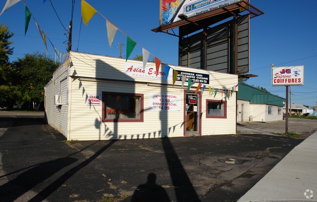
Property Record
5920 S Cedar St, Lansing, MI 48911

NEARBY LISTINGS FOR SALE OR LEASE
-
-
-
-
-
438-462 E Edgewood Blvd & SEC American Rd & E Edgewood Blvd
Lansing, MI 48911
$16.00 SF/YR
49,265 SF
Retail
-
-
-
View all Lansing listings for sale on LoopNet.com
Property Detail
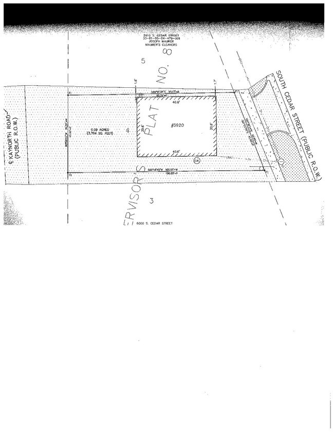
5920 S Cedar St
Lansing-East Lansing, MI
Supervisors Plat
01-05-04-479-011
LOT 4 SUPERVISORS PLAT NO 8 T3N R2W
Restaurantdrivein
Ingham
X
Michigan
26065C0141D
4
2024
0.09 AC
2025
Southern Lansing
005303
West Michigan
1,200 SF
DEMOGRAPHICS near 5920 S Cedar St
1 Mile
3 Mile
5 Mile
2024 Total Population
9,683
70,288
128,872
2029 Population
9,691
69,970
128,813
Pop Growth 2024-2029
+ 0.08%
(0.45%)
(0.05%)
Average Age
39
38
37
2024 Total Households
4,372
30,051
55,559
HH Growth 2024-2029
(0.11%)
(0.51%)
(0.07%)
Median Household Inc
$48,830
$51,530
$50,211
Avg Household Size
2.10
2.30
2.20
2024 Avg HH Vehicles
1.00
2.00
2.00
Median Home Value
$120,436
$130,220
$133,546
Median Year Built
1972
1969
1967
Nearby Places
Map Layers
Map Styles
 Street
 Aerial
- Restaurants
- Banks
- Shops
- Fitness
- Groceries
PUBLIC TRANSPORTATION
COMMUTER RAIL
DRIVE
WALK
Distance
11 min
7.5 mi
AIRPORT
Capital Region International
DRIVE
WALK
Distance
Capital Region International
16 min
8.8 mi
SALE & LEASE HISTORY
LISTING DATE
SALE/LEASE

Sep 21, 2022
For Sale
Oct 17, 2019
For Sale
Nearby Properties
Address
Land Use
TOTAL SIZE
Lot Size
Zoning
Address
Land Use
TOTAL SIZE
Lot Size
Zoning
49,336 SF
9.60 AC
F COMM
Address
Land Use
TOTAL SIZE
Lot Size
Zoning
21,447 SF
56.20 AC
RM
Address
Land Use
TOTAL SIZE
Lot Size
Zoning
3,246 SF
13.54 AC
DM-1 RE
Address
Land Use
TOTAL SIZE
Lot Size
Zoning
2,920 SF
36.77 AC
CUP
Address
Land Use
TOTAL SIZE
Lot Size
Zoning
410 AC
Address
Land Use
TOTAL SIZE
Lot Size
Zoning
8,857 SF
21.22 AC
A RESID
Address
Land Use
TOTAL SIZE
Lot Size
Zoning
31,215 SF
19.19 AC
CUP
Address
Land Use
TOTAL SIZE
Lot Size
Zoning
23,940 SF
13.44 AC
CUP
Address
Land Use
TOTAL SIZE
Lot Size
Zoning
17,920 SF
208 AC
Address
Land Use
TOTAL SIZE
Lot Size
Zoning
351 SF
20.90 AC
Address
Land Use
TOTAL SIZE
Lot Size
Zoning
1,642 SF
288 AC
DM-1 RE
Address
Land Use
TOTAL SIZE
Lot Size
Zoning
10,112 SF
12.57 AC
RM-1
Address
Land Use
TOTAL SIZE
Lot Size
Zoning
47,352 SF
2.41 AC
TC
Address
Land Use
TOTAL SIZE
Lot Size
Zoning
75,476 SF
17.70 AC
Address
Land Use
TOTAL SIZE
Lot Size
Zoning
168,480 SF
15.30 AC
G-2 WHO
Address
Land Use
TOTAL SIZE
Lot Size
Zoning
3,528 SF
230 AC
Address
Land Use
TOTAL SIZE
Lot Size
Zoning
80,080 SF
7.91 AC
D-1 PRO
Address
Land Use
TOTAL SIZE
Lot Size
Zoning
161,686 SF
220 AC
D-1 PRO
Address
Land Use
TOTAL SIZE
Lot Size
Zoning
Address
Land Use
TOTAL SIZE
Lot Size
Zoning
127,632 SF
9.06 AC
Address
Land Use
TOTAL SIZE
Lot Size
Zoning
8,469 SF
160 AC
Address
Land Use
TOTAL SIZE
Lot Size
Zoning
29,808 SF
9.66 AC
CUP
Address
Land Use
TOTAL SIZE
Lot Size
Zoning
72,722 SF
3.99 AC
A-1 RES
Address
Land Use
TOTAL SIZE
Lot Size
Zoning
26,042 SF
3.58 AC
C-2
Address
Land Use
TOTAL SIZE
Lot Size
Zoning
164 AC
Address
Land Use
TOTAL SIZE
Lot Size
Zoning
20,834 SF
11.85 AC
F COMM
Address
Land Use
TOTAL SIZE
Lot Size
Zoning
29,965 SF
4.52 AC
A-1
Address
Land Use
TOTAL SIZE
Lot Size
Zoning
1,496 SF
47.39 AC
RM-1
Address
Land Use
TOTAL SIZE
Lot Size
Zoning
138,424 SF
14.80 AC
MIXED Z
Address
Land Use
TOTAL SIZE
Lot Size
Zoning
135,318 SF
10.59 AC
G-2 WHO
The World's #1 Commercial Real Estate Marketplace
Connect with us
© 2026 CoStar Group
The information above has been obtained from sources believed reliable. While we do not doubt its accuracy we have not verified it and make no guarantee, warranty or representation about it. It is your responsibility to independently confirm its accuracy and completeness. Any projections, opinions, assumptions, or estimates used are for example only and do not represent the current or future performance of the property. The value of this transaction to you depends on tax and other factors which should be evaluated by your tax, financial, and legal advisors. You and your advisors should conduct a careful, independent investigation of the property to determine to your satisfaction the suitability of the property for your needs.