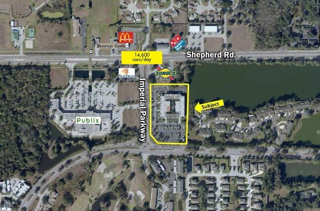
Property Record
5925 Imperial Pky, Mulberry, FL 33860


Current Lease Availabilities
NEARBY LISTINGS FOR SALE OR LEASE
Property Detail
5925 Imperial Pky
23-29-26-000000-031010
Alameda Heights
Officebuilding
BEG NE COR NW1/4 OF NW1/4 RUN S 50 FT E 38.64 FT S 01 DEG 31 MIN 30 SEC W 200.21 FT FOR POB CONT S 01 DEG 31 MIN 30 SEC W 591.89 FT N 88 DEG 28 MIN 30 SEC W 276.74 FT N 40 DEG 41 MIN 14 SEC W 107.96 FT N 500.71 FT E 365.33 FT TO POB
A
Polk
12105C0490G
Florida
2024
4.72 AC
2025
Polk County
014906
Tampa/St Petersburg
79,100 SF
Lakeland-Winter Haven, FL
DEMOGRAPHICS near 5925 Imperial Pky
1 Mile
3 Mile
5 Mile
2024 Total Population
7,051
46,469
85,472
2029 Population
8,349
55,174
101,425
Pop Growth 2024-2029
+ 18.41%
+ 18.73%
+ 18.66%
Average Age
38
39
40
2024 Total Households
2,675
17,485
31,812
HH Growth 2024-2029
+ 18.36%
+ 18.66%
+ 18.59%
Median Household Inc
$75,221
$69,866
$74,382
Avg Household Size
2.60
2.60
2.60
2024 Avg HH Vehicles
2.00
2.00
2.00
Median Home Value
$247,225
$246,771
$259,227
Median Year Built
1998
1992
1990
Nearby Places
Map Layers
Map Styles
 Street
 Aerial
- Restaurants
- Banks
- Shops
- Fitness
- Groceries
PUBLIC TRANSPORTATION
COMMUTER RAIL
Lakeland (Silver Star - Amtrak)
DRIVE
WALK
Distance
Lakeland (Silver Star - Amtrak)
18 min
8.8 mi
Freight Ports
Port of Tampa Bay
DRIVE
WALK
Distance
Port of Tampa Bay
53 min
31.6 mi
Nearby Properties
Address
Land Use
TOTAL SIZE
Lot Size
Zoning
Address
Land Use
TOTAL SIZE
Lot Size
Zoning
882,663 SF
133.57 AC
PUD
Address
Land Use
TOTAL SIZE
Lot Size
Zoning
292,243 SF
11.94 AC
PUD
Address
Land Use
TOTAL SIZE
Lot Size
Zoning
306,126 SF
25.03 AC
Address
Land Use
TOTAL SIZE
Lot Size
Zoning
214,889 SF
23.50 AC
Address
Land Use
TOTAL SIZE
Lot Size
Zoning
126,269 SF
16.35 AC
Address
Land Use
TOTAL SIZE
Lot Size
Zoning
112,538 SF
23.44 AC
Address
Land Use
TOTAL SIZE
Lot Size
Zoning
76,527 SF
17.51 AC
R1
Address
Land Use
TOTAL SIZE
Lot Size
Zoning
101,103 SF
13.87 AC
Address
Land Use
TOTAL SIZE
Lot Size
Zoning
145,672 SF
16 AC
Address
Land Use
TOTAL SIZE
Lot Size
Zoning
119,901 SF
8.46 AC
Address
Land Use
TOTAL SIZE
Lot Size
Zoning
199,906 SF
19.73 AC
R2
Address
Land Use
TOTAL SIZE
Lot Size
Zoning
116,961 SF
5.01 AC
I1
Address
Land Use
TOTAL SIZE
Lot Size
Zoning
110,784 SF
15.58 AC
Address
Land Use
TOTAL SIZE
Lot Size
Zoning
81,706 SF
20.35 AC
Address
Land Use
TOTAL SIZE
Lot Size
Zoning
66,800 SF
8.65 AC
Address
Land Use
TOTAL SIZE
Lot Size
Zoning
104,418 SF
20.10 AC
Address
Land Use
TOTAL SIZE
Lot Size
Zoning
90,952 SF
7.99 AC
PUD
Address
Land Use
TOTAL SIZE
Lot Size
Zoning
110,991 SF
9.12 AC
Address
Land Use
TOTAL SIZE
Lot Size
Zoning
95,863 SF
8.10 AC
Address
Land Use
TOTAL SIZE
Lot Size
Zoning
101,500 SF
8.47 AC
Address
Land Use
TOTAL SIZE
Lot Size
Zoning
39,936 SF
3.16 AC
C4
Address
Land Use
TOTAL SIZE
Lot Size
Zoning
122,724 SF
14.05 AC
Address
Land Use
TOTAL SIZE
Lot Size
Zoning
63,640 SF
8.81 AC
C4
Address
Land Use
TOTAL SIZE
Lot Size
Zoning
27,425 SF
8.02 AC
Address
Land Use
TOTAL SIZE
Lot Size
Zoning
103,698 SF
10.86 AC
GI
Address
Land Use
TOTAL SIZE
Lot Size
Zoning
55,112 SF
4.73 AC
R1
Address
Land Use
TOTAL SIZE
Lot Size
Zoning
41,114 SF
4.94 AC
Address
Land Use
TOTAL SIZE
Lot Size
Zoning
56,689 SF
9.30 AC
Address
Land Use
TOTAL SIZE
Lot Size
Zoning
31,700 SF
8.75 AC
C4
The World's #1 Commercial Real Estate Marketplace
Connect with us
© 2025 CoStar Group
The information above has been obtained from sources believed reliable. While we do not doubt its accuracy we have not verified it and make no guarantee, warranty or representation about it. It is your responsibility to independently confirm its accuracy and completeness. Any projections, opinions, assumptions, or estimates used are for example only and do not represent the current or future performance of the property. The value of this transaction to you depends on tax and other factors which should be evaluated by your tax, financial, and legal advisors. You and your advisors should conduct a careful, independent investigation of the property to determine to your satisfaction the suitability of the property for your needs.