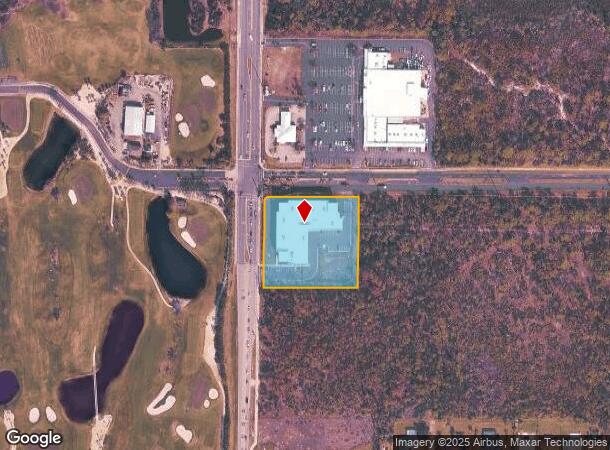
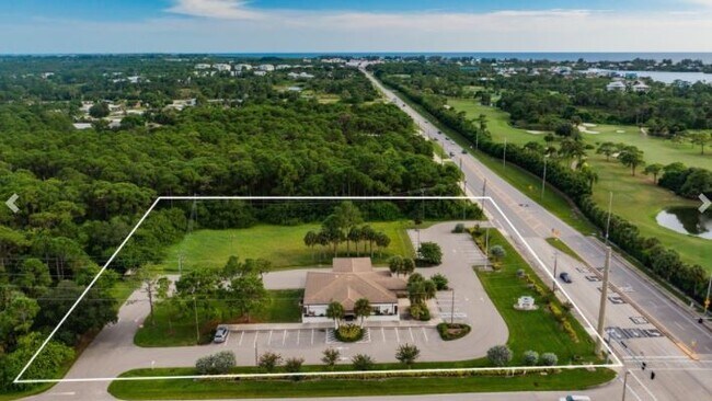
Property Record
5925 Placida Rd, Englewood, FL 34224


NEARBY LISTINGS FOR SALE OR LEASE
Property Detail
5925 Placida Rd
Punta Gorda, FL
Grove City Land Co Sub
412028226001
28 41 20 P-6-1 2.379 AC. M/L THE W 330 FT OF THE N 200 FT OF LOT 4 GROVE CITY LAND CO SUB & A PORT OF ROTOND A HTS TR-1972 DESC AS COMM AT SE COR SEC 21 TH W ALG S LINE 939.7 FT FOR POB TH N 115.11 FT TO S ROW ROTONDA BLVD W 330 FT TO E ROW SR7
Publicstorage
Charlotte
AE
Florida
12015C0193G
4
2024
2.39 AC
2025
Charlotte County
030505
Southwest Florida
101,832 SF
DEMOGRAPHICS near 5925 Placida Rd
1 Mile
3 Mile
5 Mile
2024 Total Population
3,403
18,357
44,455
2029 Population
4,162
22,254
54,158
Pop Growth 2024-2029
+ 22.30%
+ 21.23%
+ 21.83%
Average Age
60
59
58
2024 Total Households
1,863
9,274
22,060
HH Growth 2024-2029
+ 22.49%
+ 21.47%
+ 22.11%
Median Household Inc
$46,633
$55,384
$59,685
Avg Household Size
1.80
1.90
2.00
2024 Avg HH Vehicles
1.00
2.00
2.00
Median Home Value
$260,117
$273,329
$274,758
Median Year Built
1988
1991
1991
Nearby Places
Map Layers
Map Styles
 Street
 Aerial
- Restaurants
- Banks
- Shops
- Fitness
- Groceries
PUBLIC TRANSPORTATION
AIRPORT
Punta Gorda
DRIVE
WALK
Distance
Punta Gorda
49 min
29.2 mi
SALE & LEASE HISTORY
LISTING DATE
SALE/LEASE

Sep 24, 2021
For Sale
Jun 26, 2017
For Sale
Nearby Properties
Address
Land Use
TOTAL SIZE
Lot Size
Zoning
Address
Land Use
TOTAL SIZE
Lot Size
Zoning
2,387.99 AC
ES
Address
Land Use
TOTAL SIZE
Lot Size
Zoning
105,990 SF
17.30 AC
RMF15
Address
Land Use
TOTAL SIZE
Lot Size
Zoning
28,490 SF
172 AC
PKR
Address
Land Use
TOTAL SIZE
Lot Size
Zoning
33,654 SF
10.19 AC
RMF5
Address
Land Use
TOTAL SIZE
Lot Size
Zoning
107,736 SF
35.90 AC
RMF5
Address
Land Use
TOTAL SIZE
Lot Size
Zoning
38,036 SF
9.09 AC
RMF15
Address
Land Use
TOTAL SIZE
Lot Size
Zoning
25,777 SF
12.18 AC
PD
Address
Land Use
TOTAL SIZE
Lot Size
Zoning
25,685 SF
126.18 AC
RMF-T
Address
Land Use
TOTAL SIZE
Lot Size
Zoning
55,760 SF
3.18 AC
CG
Address
Land Use
TOTAL SIZE
Lot Size
Zoning
25,478 SF
11.06 AC
IG
Address
Land Use
TOTAL SIZE
Lot Size
Zoning
106,737 SF
20.80 AC
RMF5
Address
Land Use
TOTAL SIZE
Lot Size
Zoning
40,376 SF
11.18 AC
CG
Address
Land Use
TOTAL SIZE
Lot Size
Zoning
24,708 SF
14.89 AC
CT
Address
Land Use
TOTAL SIZE
Lot Size
Zoning
3,935 SF
36.92 AC
RMF10
Address
Land Use
TOTAL SIZE
Lot Size
Zoning
50,080 SF
5.09 AC
CG
Address
Land Use
TOTAL SIZE
Lot Size
Zoning
15.79 AC
CT
Address
Land Use
TOTAL SIZE
Lot Size
Zoning
38.60 AC
PD
Address
Land Use
TOTAL SIZE
Lot Size
Zoning
26,248 SF
6.32 AC
PD
Address
Land Use
TOTAL SIZE
Lot Size
Zoning
25,130 SF
21.98 AC
RE1
Address
Land Use
TOTAL SIZE
Lot Size
Zoning
27,501 SF
3.82 AC
CG
Address
Land Use
TOTAL SIZE
Lot Size
Zoning
20,160 SF
3.04 AC
CG
Address
Land Use
TOTAL SIZE
Lot Size
Zoning
5,980 SF
0.40 AC
BBI
Address
Land Use
TOTAL SIZE
Lot Size
Zoning
15,190 SF
154.40 AC
RSF5
Address
Land Use
TOTAL SIZE
Lot Size
Zoning
8.47 AC
RMF10
Address
Land Use
TOTAL SIZE
Lot Size
Zoning
33.01 AC
CG
Address
Land Use
TOTAL SIZE
Lot Size
Zoning
10 AC
RMF10
Address
Land Use
TOTAL SIZE
Lot Size
Zoning
18.62 AC
RMF15
Address
Land Use
TOTAL SIZE
Lot Size
Zoning
5.96 AC
RMF10
Address
Land Use
TOTAL SIZE
Lot Size
Zoning
12,623 SF
6.37 AC
RMF5
The World's #1 Commercial Real Estate Marketplace
Connect with us
© 2025 CoStar Group
The information above has been obtained from sources believed reliable. While we do not doubt its accuracy we have not verified it and make no guarantee, warranty or representation about it. It is your responsibility to independently confirm its accuracy and completeness. Any projections, opinions, assumptions, or estimates used are for example only and do not represent the current or future performance of the property. The value of this transaction to you depends on tax and other factors which should be evaluated by your tax, financial, and legal advisors. You and your advisors should conduct a careful, independent investigation of the property to determine to your satisfaction the suitability of the property for your needs.