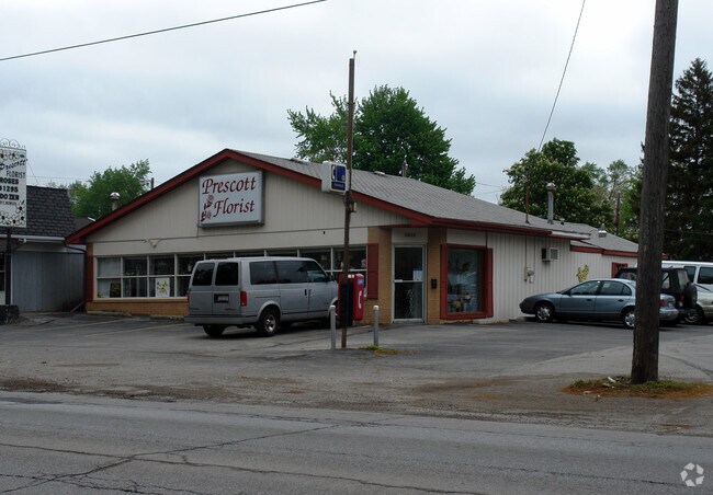
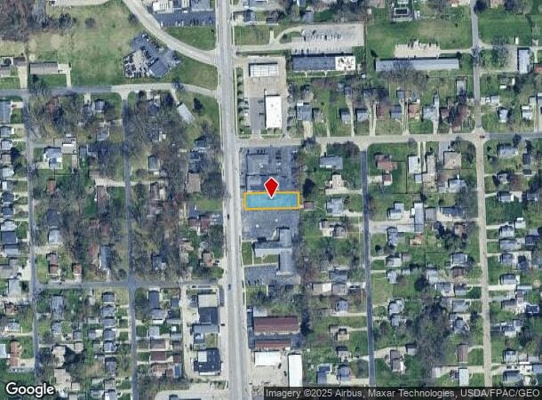
Property Record
5926 Secor Rd, Toledo, OH 43623

NEARBY LISTINGS FOR SALE OR LEASE
Property Detail
5926 Secor Rd
Toledo, OH
Trilby Place
23-64631
TRILBY PLACE LOT 10 N 27.38 FT & S 22.62 FT LOTS 11 & 12 EX
Parkinglot
Lucas
X
Ohio
39095C0076F
10
0
0.21 AC
2025
West/Sylvania
008303
Toledo
1,880 SF
DEMOGRAPHICS near 5926 Secor Rd
1 Mile
3 Mile
5 Mile
2024 Total Population
10,003
74,078
166,017
2029 Population
9,725
72,852
163,843
Pop Growth 2024-2029
(2.78%)
(1.66%)
(1.31%)
Average Age
41
41
40
2024 Total Households
4,272
32,237
69,798
HH Growth 2024-2029
(2.83%)
(1.70%)
(1.38%)
Median Household Inc
$59,967
$65,273
$60,907
Avg Household Size
2.30
2.30
2.30
2024 Avg HH Vehicles
2.00
2.00
2.00
Median Home Value
$141,336
$153,229
$151,104
Median Year Built
1962
1962
1959
Nearby Places
Map Layers
Map Styles
 Street
 Aerial
- Restaurants
- Banks
- Shops
- Fitness
- Groceries
PUBLIC TRANSPORTATION
AIRPORT
Eugene F Kranz Toledo Express
DRIVE
WALK
Distance
Eugene F Kranz Toledo Express
38 min
22.1 mi
Detroit Metro Wayne County
DRIVE
WALK
Distance
Detroit Metro Wayne County
62 min
46.6 mi
Nearby Properties
Address
Land Use
TOTAL SIZE
Lot Size
Zoning
Address
Land Use
TOTAL SIZE
Lot Size
Zoning
1,972,579 SF
76.32 AC
10-IG
Address
Land Use
TOTAL SIZE
Lot Size
Zoning
693,900 SF
76.32 AC
10-IG
Address
Land Use
TOTAL SIZE
Lot Size
Zoning
448,269 SF
29.52 AC
10-IC
Address
Land Use
TOTAL SIZE
Lot Size
Zoning
253,662 SF
16.59 AC
10-MX
Address
Land Use
TOTAL SIZE
Lot Size
Zoning
15.79 AC
31-B4
Address
Land Use
TOTAL SIZE
Lot Size
Zoning
165,739 SF
17.77 AC
Address
Land Use
TOTAL SIZE
Lot Size
Zoning
76.32 AC
10-IG
Address
Land Use
TOTAL SIZE
Lot Size
Zoning
7.71 AC
10-CRSO
Address
Land Use
TOTAL SIZE
Lot Size
Zoning
12.52 AC
10-CRSO
Address
Land Use
TOTAL SIZE
Lot Size
Zoning
61.03 AC
PUD: PLANN
Address
Land Use
TOTAL SIZE
Lot Size
Zoning
293,770 SF
13.95 AC
10-RS6
Address
Land Use
TOTAL SIZE
Lot Size
Zoning
90,113 SF
11.83 AC
10-RS6
Address
Land Use
TOTAL SIZE
Lot Size
Zoning
166,837 SF
23.82 AC
10-MX
Address
Land Use
TOTAL SIZE
Lot Size
Zoning
222,493 SF
29.88 AC
10-IC
Address
Land Use
TOTAL SIZE
Lot Size
Zoning
49,960 SF
8.33 AC
10-CO
Address
Land Use
TOTAL SIZE
Lot Size
Zoning
49,960 SF
8.33 AC
10-CO
Address
Land Use
TOTAL SIZE
Lot Size
Zoning
154,003 SF
14 AC
10-MX
Address
Land Use
TOTAL SIZE
Lot Size
Zoning
61,718 SF
7 AC
Address
Land Use
TOTAL SIZE
Lot Size
Zoning
52,429 SF
3.79 AC
10-CO
Address
Land Use
TOTAL SIZE
Lot Size
Zoning
161,884 SF
3.09 AC
10-RM36
Address
Land Use
TOTAL SIZE
Lot Size
Zoning
135,978 SF
14.01 AC
31-B2
Address
Land Use
TOTAL SIZE
Lot Size
Zoning
123,985 SF
9.74 AC
10-MX
Address
Land Use
TOTAL SIZE
Lot Size
Zoning
84,485 SF
8.41 AC
20-C2
Address
Land Use
TOTAL SIZE
Lot Size
Zoning
109,712 SF
10.64 AC
10-MX
Address
Land Use
TOTAL SIZE
Lot Size
Zoning
71,506 SF
2.71 AC
10-CR
Address
Land Use
TOTAL SIZE
Lot Size
Zoning
64,331 SF
6.82 AC
10-RM36
Address
Land Use
TOTAL SIZE
Lot Size
Zoning
71,918 SF
7 AC
10-RS6
Address
Land Use
TOTAL SIZE
Lot Size
Zoning
86,241 SF
8.69 AC
10-RS6
Address
Land Use
TOTAL SIZE
Lot Size
Zoning
55,260 SF
2.46 AC
10-CR
Address
Land Use
TOTAL SIZE
Lot Size
Zoning
78,266 SF
13.57 AC
20-S1
The World's #1 Commercial Real Estate Marketplace
Connect with us
© 2026 CoStar Group
The information above has been obtained from sources believed reliable. While we do not doubt its accuracy we have not verified it and make no guarantee, warranty or representation about it. It is your responsibility to independently confirm its accuracy and completeness. Any projections, opinions, assumptions, or estimates used are for example only and do not represent the current or future performance of the property. The value of this transaction to you depends on tax and other factors which should be evaluated by your tax, financial, and legal advisors. You and your advisors should conduct a careful, independent investigation of the property to determine to your satisfaction the suitability of the property for your needs.