Property Record
5927 Avenue B, Jacksonville, FL 32209


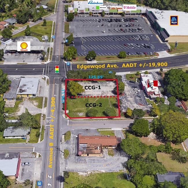
Current Lease Availabilities
Property Detail
5927 Avenue B
Jacksonville, FL
18-17 39-1S-26E .19 ROYAL TERRACE ADDITION NO 1 LOT 15 & S 11FT LOT 14 BLK 23
086221-0010
DUVAL
Commercialacreage
Florida
CCG-2
15,14
B and X Area of moderate flood hazard, usually the area between the limits of the 100-year and 500-year floods.
0.19 AC
2025
Northwest Jacksonville
2026
Jacksonville (Florida)
011500
NEARBY LISTINGS FOR SALE OR LEASE
DEMOGRAPHICS near 5927 Avenue B
1 mile
3 mile
5 mile
2025 Total Population
9,952
90,272
184,415
2030 Population
10,641
96,862
197,955
Pop Growth 2025-2030
+ 6.92%
+ 7.30%
+ 7.34%
Average Age
40
39
39
2025 Total Households
3,922
35,300
74,249
HH Growth 2025-2030
+ 7.22%
+ 7.60%
+ 7.73%
Median Household Inc
$39,896
$35,151
$42,456
Avg Household Size
2.50
2.50
2.30
2025 Avg HH Vehicles
1.00
1.00
1.00
Median Home Value
$124,062
$129,669
$183,392
Median Year Built
1964
1963
1966
Nearby Places
Map Layers
Map Styles
 Street
 Aerial
Layers
 Traffic
 Biking
Places
Listings with unknown addresses are not visible on the map
- Restaurants
- Banks
- Shops
- Fitness
- Groceries
PUBLIC TRANSPORTATION
COMMUTER RAIL
Jacksonville (Silver Meteor - Amtrak, Silver Star - Amtrak)
Drive
Walk
Distance
Jacksonville (Silver Meteor - Amtrak, Silver Star - Amtrak)
5 min
2.4 mi
AIRPORT
Jacksonville International
Drive
Walk
Distance
Jacksonville International
21 min
12.0 mi
Freight Ports
Jacksonville Port
Drive
Walk
Distance
Jacksonville Port
12 min
5.7 mi
Nearby Properties
Address
Land Use
TOTAL SIZE
Lot Size
Zoning
Address
Land Use
TOTAL SIZE
Lot Size
Zoning
705,940 SF
25.12 AC
PBF-1
Address
Land Use
TOTAL SIZE
Lot Size
Zoning
313,741 SF
37.05 AC
RMD-C
Address
Land Use
TOTAL SIZE
Lot Size
Zoning
255,048 SF
20.15 AC
IL
Address
Land Use
TOTAL SIZE
Lot Size
Zoning
119,362 SF
20.32 AC
RMD-C
Address
Land Use
TOTAL SIZE
Lot Size
Zoning
117,227 SF
14.32 AC
CCG-2
Address
Land Use
TOTAL SIZE
Lot Size
Zoning
317,474 SF
17.74 AC
IL
Address
Land Use
TOTAL SIZE
Lot Size
Zoning
258,700 SF
25.43 AC
RMD-D
Address
Land Use
TOTAL SIZE
Lot Size
Zoning
110,290 SF
3.72 AC
PBF-1
Address
Land Use
TOTAL SIZE
Lot Size
Zoning
267,290 SF
11.81 AC
IL
Address
Land Use
TOTAL SIZE
Lot Size
Zoning
154,437 SF
29.28 AC
IL
Address
Land Use
TOTAL SIZE
Lot Size
Zoning
138,076 SF
20.68 AC
RLD-60
Address
Land Use
TOTAL SIZE
Lot Size
Zoning
189,046 SF
9.43 AC
RMD-D
Address
Land Use
TOTAL SIZE
Lot Size
Zoning
165,626 SF
10.12 AC
PUD
Address
Land Use
TOTAL SIZE
Lot Size
Zoning
190,264 SF
14.62 AC
RMD-D
Address
Land Use
TOTAL SIZE
Lot Size
Zoning
392,885 SF
61.13 AC
PBF-1
Address
Land Use
TOTAL SIZE
Lot Size
Zoning
82,247 SF
112.76 AC
IH
Address
Land Use
TOTAL SIZE
Lot Size
Zoning
120,586 SF
36.53 AC
IL
Address
Land Use
TOTAL SIZE
Lot Size
Zoning
95,080 SF
9.35 AC
CRO
Address
Land Use
TOTAL SIZE
Lot Size
Zoning
85,326 SF
26.76 AC
PUD
Address
Land Use
TOTAL SIZE
Lot Size
Zoning
337,531 SF
22.07 AC
IL
Address
Land Use
TOTAL SIZE
Lot Size
Zoning
80,719 SF
5.20 AC
CRO
Address
Land Use
TOTAL SIZE
Lot Size
Zoning
323,592 SF
32.35 AC
PUD
Address
Land Use
TOTAL SIZE
Lot Size
Zoning
72,764 SF
7.16 AC
CCG-2
Address
Land Use
TOTAL SIZE
Lot Size
Zoning
168,857 SF
3.05 AC
PBF-1
Address
Land Use
TOTAL SIZE
Lot Size
Zoning
48,772 SF
2.45 AC
RMD-C
Address
Land Use
TOTAL SIZE
Lot Size
Zoning
391,714 SF
23.98 AC
IH
Address
Land Use
TOTAL SIZE
Lot Size
Zoning
298,370 SF
54.38 AC
PBF-1
Address
Land Use
TOTAL SIZE
Lot Size
Zoning
148,789 SF
11.38 AC
PUD
Address
Land Use
TOTAL SIZE
Lot Size
Zoning
109,891 SF
8.52 AC
CCG-2
Address
Land Use
TOTAL SIZE
Lot Size
Zoning
220,152 SF
11.99 AC
IL
The World's #1 Commercial Real Estate Marketplace
Connect with us
© 2026 CoStar Group
The information above has been obtained from sources believed reliable. While we do not doubt its accuracy we have not verified it and make no guarantee, warranty or representation about it. It is your responsibility to independently confirm its accuracy and completeness. Any projections, opinions, assumptions, or estimates used are for example only and do not represent the current or future performance of the property. The value of this transaction to you depends on tax and other factors which should be evaluated by your tax, financial, and legal advisors. You and your advisors should conduct a careful, independent investigation of the property to determine to your satisfaction the suitability of the property for your needs.