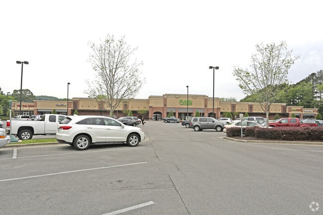
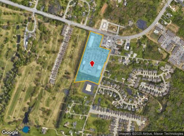
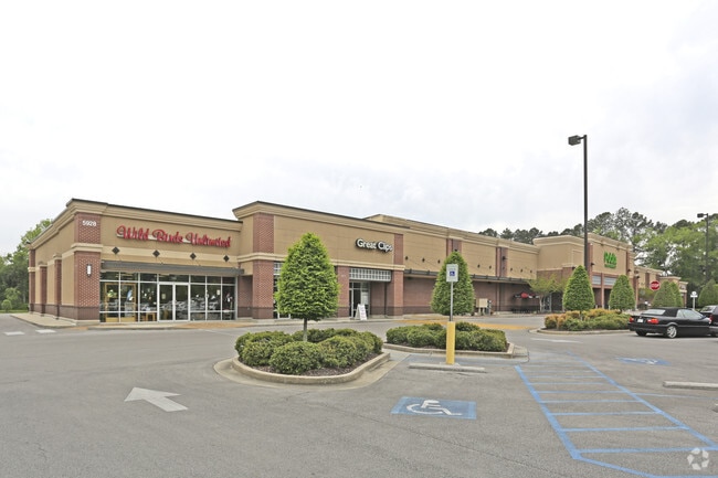
Property Record
5928 Hixson Pike, Hixson, TN 37343
NEARBY LISTINGS FOR SALE OR LEASE
Property Detail
5928 Hixson Pike
Chattanooga, TN-GA
L Creek
100-035
LT 1 CREEK PLANTATION VILLAGE HIXSON PIKE PB 85 PG 166
Supermarket
Hamilton
AE
Tennessee
47065C0239G
1
2024
10.92 AC
2024
Outlying Hamilton County
010432
Chattanooga
79,260 SF
DEMOGRAPHICS near 5928 Hixson Pike
1 Mile
3 Mile
5 Mile
2024 Total Population
4,724
29,206
72,588
2029 Population
5,108
31,086
77,175
Pop Growth 2024-2029
+ 8.13%
+ 6.44%
+ 6.32%
Average Age
46
43
42
2024 Total Households
1,948
11,969
30,121
HH Growth 2024-2029
+ 8.57%
+ 6.63%
+ 6.49%
Median Household Inc
$90,117
$78,779
$72,088
Avg Household Size
2.30
2.40
2.40
2024 Avg HH Vehicles
2.00
2.00
2.00
Median Home Value
$304,757
$263,723
$236,678
Median Year Built
1990
1983
1977
Nearby Places
Map Layers
Map Styles
 Street
 Aerial
- Restaurants
- Banks
- Shops
- Fitness
- Groceries
PUBLIC TRANSPORTATION
AIRPORT
Lovell Field
DRIVE
WALK
Distance
Lovell Field
24 min
14.3 mi
Freight Ports
Georgia Ports - Savannah
DRIVE
WALK
Distance
Georgia Ports - Savannah
419 min
372.2 mi
Nearby Properties
Address
Land Use
TOTAL SIZE
Lot Size
Zoning
Address
Land Use
TOTAL SIZE
Lot Size
Zoning
197,214 SF
19.39 AC
R4
Address
Land Use
TOTAL SIZE
Lot Size
Zoning
198 AC
Address
Land Use
TOTAL SIZE
Lot Size
Zoning
286,637 SF
20.40 AC
Address
Land Use
TOTAL SIZE
Lot Size
Zoning
286,054 SF
21.50 AC
R1
Address
Land Use
TOTAL SIZE
Lot Size
Zoning
309,974 SF
20.57 AC
R3
Address
Land Use
TOTAL SIZE
Lot Size
Zoning
122,136 SF
5.55 AC
M3
Address
Land Use
TOTAL SIZE
Lot Size
Zoning
215,672 SF
21.28 AC
Address
Land Use
TOTAL SIZE
Lot Size
Zoning
87,930 SF
4 AC
Address
Land Use
TOTAL SIZE
Lot Size
Zoning
7,693 SF
115.99 AC
R1
Address
Land Use
TOTAL SIZE
Lot Size
Zoning
1,632 SF
12.67 AC
R3
Address
Land Use
TOTAL SIZE
Lot Size
Zoning
51.50 AC
R1
Address
Land Use
TOTAL SIZE
Lot Size
Zoning
91,520 SF
10.99 AC
C2
Address
Land Use
TOTAL SIZE
Lot Size
Zoning
182,466 SF
20.95 AC
R5
Address
Land Use
TOTAL SIZE
Lot Size
Zoning
410,295 SF
38.44 AC
C2
Address
Land Use
TOTAL SIZE
Lot Size
Zoning
88,449 SF
4 AC
Address
Land Use
TOTAL SIZE
Lot Size
Zoning
132,252 SF
12.74 AC
Address
Land Use
TOTAL SIZE
Lot Size
Zoning
2,325 SF
14.13 AC
R3
Address
Land Use
TOTAL SIZE
Lot Size
Zoning
151,073 SF
9.25 AC
R4
Address
Land Use
TOTAL SIZE
Lot Size
Zoning
76,589 SF
9.71 AC
R4
Address
Land Use
TOTAL SIZE
Lot Size
Zoning
56 AC
9999
Address
Land Use
TOTAL SIZE
Lot Size
Zoning
31,511 SF
5.48 AC
Address
Land Use
TOTAL SIZE
Lot Size
Zoning
72,960 SF
9.32 AC
R3
Address
Land Use
TOTAL SIZE
Lot Size
Zoning
41,872 SF
7.87 AC
C2
Address
Land Use
TOTAL SIZE
Lot Size
Zoning
140,672 SF
12 AC
Address
Land Use
TOTAL SIZE
Lot Size
Zoning
68,635 SF
44.47 AC
Address
Land Use
TOTAL SIZE
Lot Size
Zoning
47,343 SF
4.06 AC
Address
Land Use
TOTAL SIZE
Lot Size
Zoning
125,453 SF
10.87 AC
C2
Address
Land Use
TOTAL SIZE
Lot Size
Zoning
55,185 SF
1.51 AC
C2
Address
Land Use
TOTAL SIZE
Lot Size
Zoning
30,146 SF
3.20 AC
C2
The World's #1 Commercial Real Estate Marketplace
Connect with us
© 2025 CoStar Group
The information above has been obtained from sources believed reliable. While we do not doubt its accuracy we have not verified it and make no guarantee, warranty or representation about it. It is your responsibility to independently confirm its accuracy and completeness. Any projections, opinions, assumptions, or estimates used are for example only and do not represent the current or future performance of the property. The value of this transaction to you depends on tax and other factors which should be evaluated by your tax, financial, and legal advisors. You and your advisors should conduct a careful, independent investigation of the property to determine to your satisfaction the suitability of the property for your needs.