Property Record
593 Rancocas Rd, Westampton, NJ 08060
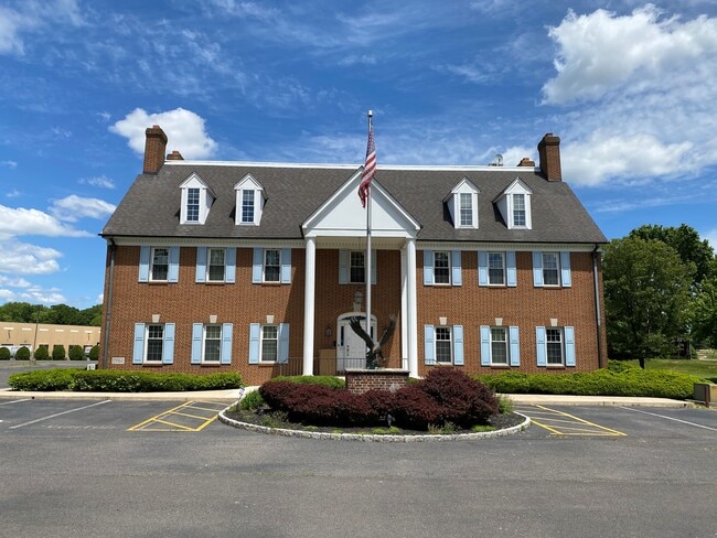

Property Detail
593 Rancocas Rd
Philadelphia-Camden-Wilmington, PA-NJ-DE-MD
FACILITY NAME: CHURCH
37-00203-0000-00011
Burlington
Officebuilding
New Jersey
B and X Area of moderate flood hazard, usually the area between the limits of the 100-year and 500-year floods.
11
0
2.35 AC
2025
North Burlington County
702701
Philadelphia
NEARBY LISTINGS FOR SALE OR LEASE
DEMOGRAPHICS near 593 Rancocas Rd
1 mile
3 mile
5 mile
2025 Total Population
3,938
56,107
150,462
2030 Population
4,086
57,852
155,059
Pop Growth 2025-2030
+ 3.76%
+ 3.11%
+ 3.06%
Average Age
43
43
42
2025 Total Households
1,415
20,718
57,352
HH Growth 2025-2030
+ 3.96%
+ 3.15%
+ 3.18%
Median Household Inc
$110,153
$109,813
$102,670
Avg Household Size
2.70
2.60
2.50
2025 Avg HH Vehicles
2.00
2.00
2.00
Median Home Value
$304,067
$304,605
$326,974
Median Year Built
1966
1972
1975
Nearby Places
Map Layers
Map Styles
 Street
 Aerial
Layers
 Traffic
 Biking
Places
Listings with unknown addresses are not visible on the map
- Restaurants
- Banks
- Shops
- Fitness
- Groceries
PUBLIC TRANSPORTATION
COMMUTER RAIL
Bristol (R7 - Southeastern Pennsylvania Transportation Authority Regional Rail (SEPTA Regional Rail))
Drive
Walk
Distance
Bristol (R7 - Southeastern Pennsylvania Transportation Authority Regional Rail (SEPTA Regional Rail))
17 min
8.3 mi
Croydon (R7 - Southeastern Pennsylvania Transportation Authority Regional Rail (SEPTA Regional Rail))
Drive
Walk
Distance
Croydon (R7 - Southeastern Pennsylvania Transportation Authority Regional Rail (SEPTA Regional Rail))
18 min
8.9 mi
AIRPORT
Trenton Mercer
Drive
Walk
Distance
Trenton Mercer
39 min
26.1 mi
Philadelphia International
Drive
Walk
Distance
Philadelphia International
42 min
27.4 mi
Freight Ports
South Jersey Port
Drive
Walk
Distance
South Jersey Port
25 min
17.2 mi
SALE & LEASE HISTORY
LISTING DATE
SALE/LEASE

Jun 02, 2021
For Lease
Jun 02, 2021
For Sale
Nearby Properties
Address
Land Use
TOTAL SIZE
Lot Size
Zoning
Address
Land Use
TOTAL SIZE
Lot Size
Zoning
86.67 AC
R-5
Address
Land Use
TOTAL SIZE
Lot Size
Zoning
14.48 AC
Address
Land Use
TOTAL SIZE
Lot Size
Zoning
14.15 AC
Address
Land Use
TOTAL SIZE
Lot Size
Zoning
97,993 SF
63.75 AC
Address
Land Use
TOTAL SIZE
Lot Size
Zoning
30.76 AC
R-9
Address
Land Use
TOTAL SIZE
Lot Size
Zoning
100 AC
R-5
Address
Land Use
TOTAL SIZE
Lot Size
Zoning
25.58 AC
Address
Land Use
TOTAL SIZE
Lot Size
Zoning
8.31 AC
Address
Land Use
TOTAL SIZE
Lot Size
Zoning
58.39 AC
B-2
Address
Land Use
TOTAL SIZE
Lot Size
Zoning
Address
Land Use
TOTAL SIZE
Lot Size
Zoning
Address
Land Use
TOTAL SIZE
Lot Size
Zoning
15.69 AC
Address
Land Use
TOTAL SIZE
Lot Size
Zoning
11.82 AC
R-5
Address
Land Use
TOTAL SIZE
Lot Size
Zoning
2,704 SF
28.75 AC
Address
Land Use
TOTAL SIZE
Lot Size
Zoning
Address
Land Use
TOTAL SIZE
Lot Size
Zoning
15.09 AC
Address
Land Use
TOTAL SIZE
Lot Size
Zoning
190,000 SF
22.17 AC
Address
Land Use
TOTAL SIZE
Lot Size
Zoning
266,966 SF
39.90 AC
I-1
Address
Land Use
TOTAL SIZE
Lot Size
Zoning
217,986 SF
39.89 AC
I-1
Address
Land Use
TOTAL SIZE
Lot Size
Zoning
Address
Land Use
TOTAL SIZE
Lot Size
Zoning
45.64 AC
Address
Land Use
TOTAL SIZE
Lot Size
Zoning
10.21 AC
FRMX
Address
Land Use
TOTAL SIZE
Lot Size
Zoning
302,372 SF
15.05 AC
Address
Land Use
TOTAL SIZE
Lot Size
Zoning
150,480 SF
10.12 AC
Address
Land Use
TOTAL SIZE
Lot Size
Zoning
17.63 AC
R-1
Address
Land Use
TOTAL SIZE
Lot Size
Zoning
300,609 SF
16.07 AC
I
Address
Land Use
TOTAL SIZE
Lot Size
Zoning
115,000 SF
14.13 AC
C
Address
Land Use
TOTAL SIZE
Lot Size
Zoning
129,830 SF
10.11 AC
Address
Land Use
TOTAL SIZE
Lot Size
Zoning
21.38 AC
R-1
Address
Land Use
TOTAL SIZE
Lot Size
Zoning
12.09 AC
The World's #1 Commercial Real Estate Marketplace
Connect with us
© 2026 CoStar Group
The information above has been obtained from sources believed reliable. While we do not doubt its accuracy we have not verified it and make no guarantee, warranty or representation about it. It is your responsibility to independently confirm its accuracy and completeness. Any projections, opinions, assumptions, or estimates used are for example only and do not represent the current or future performance of the property. The value of this transaction to you depends on tax and other factors which should be evaluated by your tax, financial, and legal advisors. You and your advisors should conduct a careful, independent investigation of the property to determine to your satisfaction the suitability of the property for your needs.