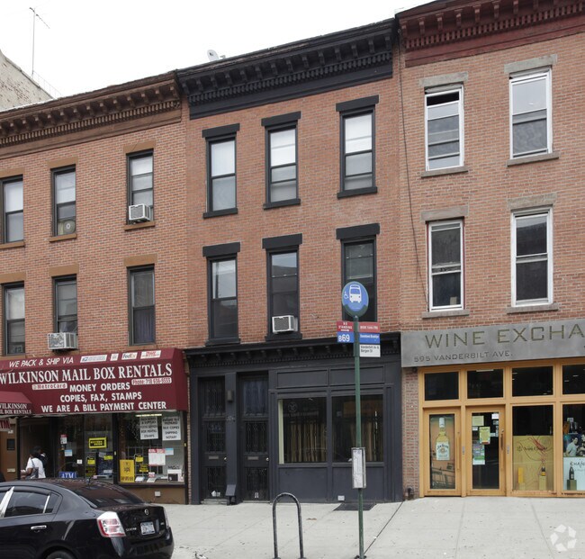
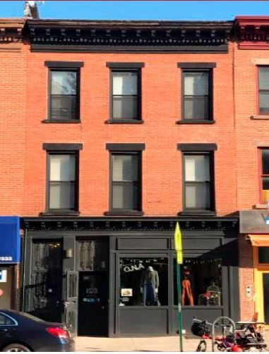
Property Record
593 Vanderbilt Ave, Brooklyn, NY 11238

NEARBY LISTINGS FOR SALE OR LEASE
Property Detail
593 Vanderbilt Ave
01138-0005
DOCID-2020051200017001
Commercialofficeresidentialmixeduse
Kings
X
New York
3604970212F
5
2024
0.04 AC
2025
North Brooklyn
020300
Long Island (New York)
2,700 SF
New York-Jersey City-White Plains, NY-NJ
DEMOGRAPHICS near 593 Vanderbilt Ave
1 Mile
3 Mile
5 Mile
2024 Total Population
176,740
1,289,609
2,771,874
2029 Population
168,773
1,220,879
2,596,882
Pop Growth 2024-2029
(4.51%)
(5.33%)
(6.31%)
Average Age
38
38
38
2024 Total Households
78,603
513,680
1,101,915
HH Growth 2024-2029
(5.00%)
(5.76%)
(6.55%)
Median Household Inc
$114,923
$78,513
$81,488
Avg Household Size
2.20
2.40
2.40
2024 Avg HH Vehicles
.00
.00
.00
Median Home Value
$1,045,272
$977,377
$883,350
Median Year Built
1947
1948
1948
Nearby Places
- Restaurants
- Banks
- Shops
- Fitness
- Groceries
PUBLIC TRANSPORTATION
TRANSIT/SUBWAY
Clinton-Washington Avenues (A,C Line) (A - New York MTA Subway (The Subway), C - New York MTA Subway (The Subway))
DRIVE
WALK
Distance
Clinton-Washington Avenues (A,C Line) (A - New York MTA Subway (The Subway), C - New York MTA Subway (The Subway))
2 min
7 min
0.4 mi
Grand Army Plaza (2 - New York MTA Subway (The Subway), 3 - New York MTA Subway (The Subway), 4 - New York MTA Subway (The Subway))
DRIVE
WALK
Distance
Grand Army Plaza (2 - New York MTA Subway (The Subway), 3 - New York MTA Subway (The Subway), 4 - New York MTA Subway (The Subway))
2 min
8 min
0.4 mi
Bergen Street (2,3 Line) (2 - New York MTA Subway (The Subway), 3 - New York MTA Subway (The Subway), 4 - New York MTA Subway (The Subway))
DRIVE
WALK
Distance
Bergen Street (2,3 Line) (2 - New York MTA Subway (The Subway), 3 - New York MTA Subway (The Subway), 4 - New York MTA Subway (The Subway))
2 min
8 min
0.4 mi
7 Avenue (B,Q Line) (B - New York MTA Subway (The Subway), Q - New York MTA Subway (The Subway))
DRIVE
WALK
Distance
7 Avenue (B,Q Line) (B - New York MTA Subway (The Subway), Q - New York MTA Subway (The Subway))
2 min
8 min
0.4 mi
Lafayette Avenue (A - New York MTA Subway (The Subway), C - New York MTA Subway (The Subway))
DRIVE
WALK
Distance
Lafayette Avenue (A - New York MTA Subway (The Subway), C - New York MTA Subway (The Subway))
2 min
12 min
0.6 mi
COMMUTER RAIL
DRIVE
WALK
Distance
2 min
11 min
0.6 mi
Nostrand Avenue Station (Far Rockaway Branch - Long Island Rail Road, Hempstead Branch - Long Island Rail Road, Long Beach Branch - Long Island Rail Road, West Hempstead Branch - Long Island Rail Road)
DRIVE
WALK
Distance
Nostrand Avenue Station (Far Rockaway Branch - Long Island Rail Road, Hempstead Branch - Long Island Rail Road, Long Beach Branch - Long Island Rail Road, West Hempstead Branch - Long Island Rail Road)
4 min
1.2 mi
AIRPORT
LaGuardia
DRIVE
WALK
Distance
LaGuardia
20 min
9.8 mi
John F Kennedy International
DRIVE
WALK
Distance
John F Kennedy International
27 min
12.9 mi
Newark Liberty International
DRIVE
WALK
Distance
Newark Liberty International
29 min
15.7 mi
Freight Ports
NY - Red Hook Container Terminal
DRIVE
WALK
Distance
NY - Red Hook Container Terminal
9 min
2.6 mi
SALE & LEASE HISTORY
LISTING DATE
SALE/LEASE

Jan 24, 2020
For Sale
Nearby Properties
Address
Land Use
TOTAL SIZE
Lot Size
Zoning
Address
Land Use
TOTAL SIZE
Lot Size
Zoning
2,812,739 SF
2.10 AC
C5-3
Address
Land Use
TOTAL SIZE
Lot Size
Zoning
7,058,736 SF
147.61 AC
M3-1
Address
Land Use
TOTAL SIZE
Lot Size
Zoning
869,038 SF
1.53 AC
M1-1
Address
Land Use
TOTAL SIZE
Lot Size
Zoning
92,440 SF
466.23 AC
R5
Address
Land Use
TOTAL SIZE
Lot Size
Zoning
2,210,200 SF
2.58 AC
C5-5
Address
Land Use
TOTAL SIZE
Lot Size
Zoning
1,499,568 SF
1.66 AC
C5-5
Address
Land Use
TOTAL SIZE
Lot Size
Zoning
1,617,206 SF
1.23 AC
C5-5
Address
Land Use
TOTAL SIZE
Lot Size
Zoning
2,542,066 SF
174.49 AC
R3-2
Address
Land Use
TOTAL SIZE
Lot Size
Zoning
1,503,150 SF
20.47 AC
R5
Address
Land Use
TOTAL SIZE
Lot Size
Zoning
1,075,808 SF
1.12 AC
C5-5
Address
Land Use
TOTAL SIZE
Lot Size
Zoning
1,141,276 SF
1.21 AC
C5-5
Address
Land Use
TOTAL SIZE
Lot Size
Zoning
393.54 AC
PARK
Address
Land Use
TOTAL SIZE
Lot Size
Zoning
1,289,243 SF
1.14 AC
C5-5
Address
Land Use
TOTAL SIZE
Lot Size
Zoning
2,948,300 SF
27.71 AC
R7-2
Address
Land Use
TOTAL SIZE
Lot Size
Zoning
577,381 SF
3.19 AC
R6
Address
Land Use
TOTAL SIZE
Lot Size
Zoning
890,142 SF
2.22 AC
R7-1
Address
Land Use
TOTAL SIZE
Lot Size
Zoning
1,079,361 SF
1.07 AC
C5-3
Address
Land Use
TOTAL SIZE
Lot Size
Zoning
902,000 SF
6.44 AC
M3-1
Address
Land Use
TOTAL SIZE
Lot Size
Zoning
943,802 SF
0.97 AC
C6-9
Address
Land Use
TOTAL SIZE
Lot Size
Zoning
1,258,851 SF
2.20 AC
C6-4
Address
Land Use
TOTAL SIZE
Lot Size
Zoning
1,658,649 SF
15.93 AC
R7-2
Address
Land Use
TOTAL SIZE
Lot Size
Zoning
830,879 SF
1 AC
C5-4
Address
Land Use
TOTAL SIZE
Lot Size
Zoning
835,231 SF
11.32 AC
R6
Address
Land Use
TOTAL SIZE
Lot Size
Zoning
1,021,351 SF
1.24 AC
C5-5
Address
Land Use
TOTAL SIZE
Lot Size
Zoning
813,363 SF
3.50 AC
C6-4
Address
Land Use
TOTAL SIZE
Lot Size
Zoning
990,250 SF
1.12 AC
C6-9
Address
Land Use
TOTAL SIZE
Lot Size
Zoning
1,061,228 SF
8.86 AC
R5
Address
Land Use
TOTAL SIZE
Lot Size
Zoning
1,007,569 SF
0.98 AC
C5-5
Address
Land Use
TOTAL SIZE
Lot Size
Zoning
579,404 SF
4.80 AC
R6
Address
Land Use
TOTAL SIZE
Lot Size
Zoning
974,958 SF
1.03 AC
C5-5
The World's #1 Commercial Real Estate Marketplace
Connect with us
© 2025 CoStar Group
The information above has been obtained from sources believed reliable. While we do not doubt its accuracy we have not verified it and make no guarantee, warranty or representation about it. It is your responsibility to independently confirm its accuracy and completeness. Any projections, opinions, assumptions, or estimates used are for example only and do not represent the current or future performance of the property. The value of this transaction to you depends on tax and other factors which should be evaluated by your tax, financial, and legal advisors. You and your advisors should conduct a careful, independent investigation of the property to determine to your satisfaction the suitability of the property for your needs.