Property Record
5933 Baumhart Rd, Lorain, OH 44053
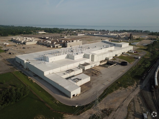
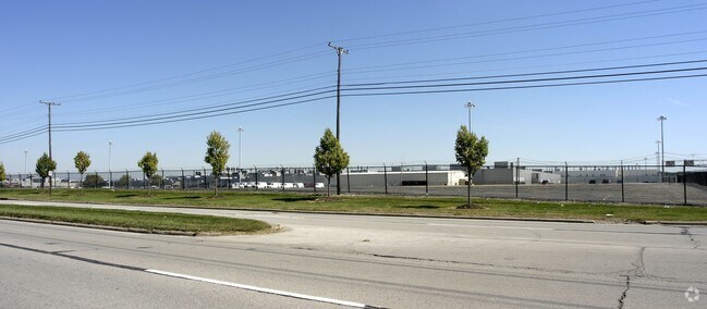
Property Detail
5933 Baumhart Rd
Cleveland-Elyria, OH
FROM 01-00-007-103-001 COVENANT NOT TO SUE PARCEL SEE INDUSTRIAL REPORT
01-00-010-000-030
LORAIN
Industrialgeneral
Ohio
A Areas with a 1% annual chance of flooding and a 26% chance of flooding over the life of a 30-year mortgage.
15.18 AC
2024
Outlying Lorain
2024
Cleveland
097202
NEARBY LISTINGS FOR SALE OR LEASE
DEMOGRAPHICS near 5933 Baumhart Rd
1 mile
3 mile
5 mile
2025 Total Population
28
20,861
58,979
2030 Population
29
21,541
60,269
Pop Growth 2025-2030
+ 3.57%
+ 3.26%
+ 2.19%
Average Age
38
44
43
2025 Total Households
9
8,427
24,719
HH Growth 2025-2030
+ 11.11%
+ 3.37%
+ 2.23%
Median Household Inc
$137,500
$87,791
$77,139
Avg Household Size
2.90
2.40
2.30
2025 Avg HH Vehicles
2.00
2.00
2.00
Median Home Value
$325,000
$259,651
$208,100
Median Year Built
2001
1984
1971
Nearby Places
Map Layers
Map Styles
 Street
 Aerial
Layers
 Traffic
 Biking
Places
Listings with unknown addresses are not visible on the map
- Restaurants
- Banks
- Shops
- Fitness
- Groceries
PUBLIC TRANSPORTATION
AIRPORT
Cleveland-Hopkins International
Drive
Walk
Distance
Cleveland-Hopkins International
43 min
28.7 mi
Freight Ports
Port of Toledo
Drive
Walk
Distance
Port of Toledo
102 min
82.3 mi
SALE & LEASE HISTORY
LISTING DATE
SALE/LEASE

Oct 17, 2017
For Lease
Nearby Properties
Address
Land Use
TOTAL SIZE
Lot Size
Zoning
Address
Land Use
TOTAL SIZE
Lot Size
Zoning
1,040,560 SF
28.68 AC
Address
Land Use
TOTAL SIZE
Lot Size
Zoning
33,339 SF
30.60 AC
Address
Land Use
TOTAL SIZE
Lot Size
Zoning
118,624 SF
19.80 AC
Address
Land Use
TOTAL SIZE
Lot Size
Zoning
111,373 SF
9.35 AC
Address
Land Use
TOTAL SIZE
Lot Size
Zoning
43,576 SF
12.37 AC
Address
Land Use
TOTAL SIZE
Lot Size
Zoning
35,502 SF
23.29 AC
Address
Land Use
TOTAL SIZE
Lot Size
Zoning
30,744 SF
5.10 AC
Address
Land Use
TOTAL SIZE
Lot Size
Zoning
9,880 SF
3.90 AC
Address
Land Use
TOTAL SIZE
Lot Size
Zoning
67,408 SF
14.83 AC
Address
Land Use
TOTAL SIZE
Lot Size
Zoning
45,209 SF
5.09 AC
Address
Land Use
TOTAL SIZE
Lot Size
Zoning
64,442 SF
7.67 AC
Address
Land Use
TOTAL SIZE
Lot Size
Zoning
76,819 SF
3.62 AC
Address
Land Use
TOTAL SIZE
Lot Size
Zoning
139,368 SF
13.48 AC
Address
Land Use
TOTAL SIZE
Lot Size
Zoning
23,068 SF
2.94 AC
Address
Land Use
TOTAL SIZE
Lot Size
Zoning
127,146 SF
9.54 AC
Address
Land Use
TOTAL SIZE
Lot Size
Zoning
19,947 SF
8.14 AC
Address
Land Use
TOTAL SIZE
Lot Size
Zoning
48,913 SF
3.40 AC
Address
Land Use
TOTAL SIZE
Lot Size
Zoning
174.62 AC
Address
Land Use
TOTAL SIZE
Lot Size
Zoning
75,461 SF
1.32 AC
Address
Land Use
TOTAL SIZE
Lot Size
Zoning
33,368 SF
7.82 AC
Address
Land Use
TOTAL SIZE
Lot Size
Zoning
1.42 AC
Address
Land Use
TOTAL SIZE
Lot Size
Zoning
128,040 SF
7.06 AC
Address
Land Use
TOTAL SIZE
Lot Size
Zoning
87,914 SF
5.03 AC
Address
Land Use
TOTAL SIZE
Lot Size
Zoning
19,810 SF
7.38 AC
Address
Land Use
TOTAL SIZE
Lot Size
Zoning
170,688 SF
16.21 AC
Address
Land Use
TOTAL SIZE
Lot Size
Zoning
741,945 SF
66.31 AC
Address
Land Use
TOTAL SIZE
Lot Size
Zoning
22,044 SF
7.34 AC
Address
Land Use
TOTAL SIZE
Lot Size
Zoning
6,816 SF
1.02 AC
Address
Land Use
TOTAL SIZE
Lot Size
Zoning
33,882 SF
3.28 AC
Address
Land Use
TOTAL SIZE
Lot Size
Zoning
23,911 SF
2.26 AC
The World's #1 Commercial Real Estate Marketplace
Connect with us
© 2026 CoStar Group
The information above has been obtained from sources believed reliable. While we do not doubt its accuracy we have not verified it and make no guarantee, warranty or representation about it. It is your responsibility to independently confirm its accuracy and completeness. Any projections, opinions, assumptions, or estimates used are for example only and do not represent the current or future performance of the property. The value of this transaction to you depends on tax and other factors which should be evaluated by your tax, financial, and legal advisors. You and your advisors should conduct a careful, independent investigation of the property to determine to your satisfaction the suitability of the property for your needs.