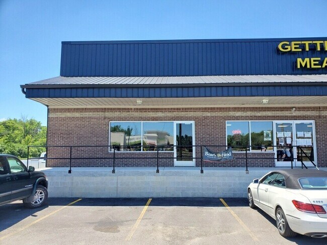
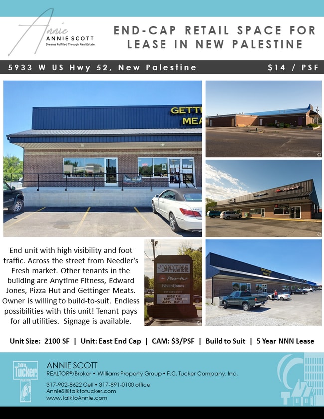
Property Record
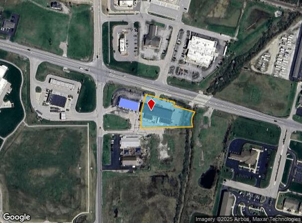
5933 W Us Highway 52, New Palestine, IN 46163
NEARBY LISTINGS FOR SALE OR LEASE
Property Detail
5933 W Us Highway 52
30-10-30-204-002.001-013
New Palestine Plaza Minor Subdivision
Stripcommercialcenter
NEW PALESTINE PLAZA MS PT L2 OF 30-15-6 1.167AC A REPLAT OF TREVOR T LLOYD-JONES MD MS
A
Hancock
18145C0010C
Indiana
2024
1.17 AC
2024
Hancock County
410802
Indianapolis
13,000 SF
Indianapolis-Carmel-Anderson, IN
DEMOGRAPHICS near 5933 W Us Highway 52
1 Mile
3 Mile
5 Mile
2024 Total Population
2,529
12,484
37,487
2029 Population
2,764
13,700
39,426
Pop Growth 2024-2029
+ 9.29%
+ 9.74%
+ 5.17%
Average Age
43
42
40
2024 Total Households
933
4,640
13,860
HH Growth 2024-2029
+ 9.75%
+ 10.17%
+ 5.59%
Median Household Inc
$105,714
$98,400
$94,690
Avg Household Size
2.70
2.60
2.70
2024 Avg HH Vehicles
3.00
3.00
2.00
Median Home Value
$273,410
$266,115
$250,412
Median Year Built
1990
1991
1991
Nearby Places
- Restaurants
- Banks
- Shops
- Fitness
- Groceries
PUBLIC TRANSPORTATION
AIRPORT
Indianapolis International
DRIVE
WALK
Distance
Indianapolis International
45 min
25.4 mi
SALE & LEASE HISTORY
LISTING DATE
SALE/LEASE

Sep 26, 2018
For Lease
Jun 08, 2020
For Lease
Jul 19, 2017
For Lease
Jan 30, 2020
For Lease
Nearby Properties
Address
Land Use
TOTAL SIZE
Lot Size
Zoning
Address
Land Use
TOTAL SIZE
Lot Size
Zoning
107,950 SF
10.93 AC
Address
Land Use
TOTAL SIZE
Lot Size
Zoning
48,838 SF
15.09 AC
Address
Land Use
TOTAL SIZE
Lot Size
Zoning
12,786 SF
24.78 AC
ZO01
Address
Land Use
TOTAL SIZE
Lot Size
Zoning
16,282 SF
10.23 AC
Address
Land Use
TOTAL SIZE
Lot Size
Zoning
53,658 SF
12.24 AC
Address
Land Use
TOTAL SIZE
Lot Size
Zoning
21,778 SF
3.17 AC
Address
Land Use
TOTAL SIZE
Lot Size
Zoning
53,337 SF
10 AC
Address
Land Use
TOTAL SIZE
Lot Size
Zoning
3,168 SF
2.56 AC
Address
Land Use
TOTAL SIZE
Lot Size
Zoning
5,805 SF
2.54 AC
Address
Land Use
TOTAL SIZE
Lot Size
Zoning
3,806 SF
4.96 AC
Address
Land Use
TOTAL SIZE
Lot Size
Zoning
10,454 SF
8.69 AC
Address
Land Use
TOTAL SIZE
Lot Size
Zoning
9,900 SF
3.86 AC
Address
Land Use
TOTAL SIZE
Lot Size
Zoning
21,737 SF
6 AC
Address
Land Use
TOTAL SIZE
Lot Size
Zoning
4,956 SF
1.52 AC
Address
Land Use
TOTAL SIZE
Lot Size
Zoning
5,120 SF
2.79 AC
Address
Land Use
TOTAL SIZE
Lot Size
Zoning
10,941 SF
1.24 AC
Address
Land Use
TOTAL SIZE
Lot Size
Zoning
9,065 SF
1.59 AC
Address
Land Use
TOTAL SIZE
Lot Size
Zoning
Address
Land Use
TOTAL SIZE
Lot Size
Zoning
4,200 SF
5 AC
Address
Land Use
TOTAL SIZE
Lot Size
Zoning
7,200 SF
6.62 AC
Address
Land Use
TOTAL SIZE
Lot Size
Zoning
6,264 SF
161.88 AC
Address
Land Use
TOTAL SIZE
Lot Size
Zoning
6,852 SF
2 AC
Address
Land Use
TOTAL SIZE
Lot Size
Zoning
12,800 SF
5.52 AC
Address
Land Use
TOTAL SIZE
Lot Size
Zoning
1,025 SF
25.30 AC
Address
Land Use
TOTAL SIZE
Lot Size
Zoning
11,088 SF
1.23 AC
Address
Land Use
TOTAL SIZE
Lot Size
Zoning
7,834 SF
1.54 AC
Address
Land Use
TOTAL SIZE
Lot Size
Zoning
8,394 SF
1.26 AC
Address
Land Use
TOTAL SIZE
Lot Size
Zoning
5,280 SF
1.21 AC
Address
Land Use
TOTAL SIZE
Lot Size
Zoning
4,688 SF
1.70 AC
The World's #1 Commercial Real Estate Marketplace
Connect with us
© 2025 CoStar Group
The information above has been obtained from sources believed reliable. While we do not doubt its accuracy we have not verified it and make no guarantee, warranty or representation about it. It is your responsibility to independently confirm its accuracy and completeness. Any projections, opinions, assumptions, or estimates used are for example only and do not represent the current or future performance of the property. The value of this transaction to you depends on tax and other factors which should be evaluated by your tax, financial, and legal advisors. You and your advisors should conduct a careful, independent investigation of the property to determine to your satisfaction the suitability of the property for your needs.