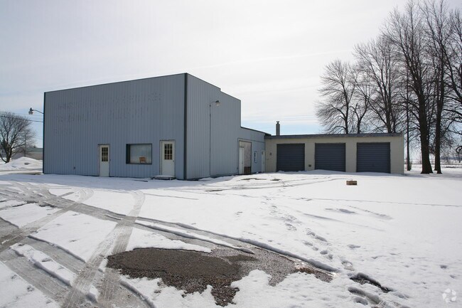
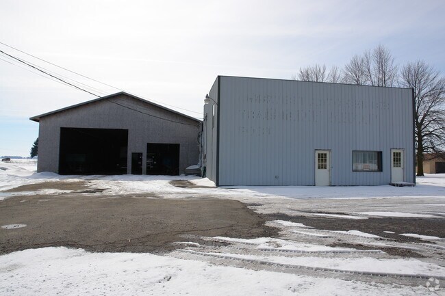
Property Record
5934 E Monroe Rd, Breckenridge, MI 48615

Property Detail
5934 E Monroe Rd
Alma, MI
WD L 579 P 436 COM 15 RDS 8 FT W OF NE COR OF SEC, TH S 10 RDS 10 FT 6 IN, W 7 RDS 12 FT, N 10 RDS 10 FT 6 IN, E 7 RDS 12 FT
02-025-008-00
Gratiot
Commercialnec
Michigan
B and X Area of moderate flood hazard, usually the area between the limits of the 100-year and 500-year floods.
0.57 AC
2023
Michigan North Central Area
2025
Other Market Areas
000200
NEARBY LISTINGS FOR SALE OR LEASE
DEMOGRAPHICS near 5934 E Monroe Rd
1 mile
3 mile
5 mile
2025 Total Population
1,425
2,261
3,398
2030 Population
1,423
2,252
3,376
Pop Growth 2025-2030
(0.14%)
(0.40%)
(0.65%)
Average Age
41
42
43
2025 Total Households
599
934
1,378
HH Growth 2025-2030
(0.17%)
(0.32%)
(0.58%)
Median Household Inc
$65,390
$66,699
$68,757
Avg Household Size
2.40
2.40
2.40
2025 Avg HH Vehicles
2.00
2.00
2.00
Median Home Value
$140,064
$148,000
$154,629
Median Year Built
1964
1964
1964
Nearby Places
Map Layers
Map Styles
 Street
 Aerial
Layers
 Traffic
 Biking
Places
Listings with unknown addresses are not visible on the map
- Restaurants
- Banks
- Shops
- Fitness
- Groceries
PUBLIC TRANSPORTATION
AIRPORT
MBS International
Drive
Walk
Distance
MBS International
48 min
33.4 mi
Nearby Properties
Address
Land Use
TOTAL SIZE
Lot Size
Zoning
Address
Land Use
TOTAL SIZE
Lot Size
Zoning
Address
Land Use
TOTAL SIZE
Lot Size
Zoning
Address
Land Use
TOTAL SIZE
Lot Size
Zoning
130.40 AC
Address
Land Use
TOTAL SIZE
Lot Size
Zoning
Address
Land Use
TOTAL SIZE
Lot Size
Zoning
Address
Land Use
TOTAL SIZE
Lot Size
Zoning
159 AC
Address
Land Use
TOTAL SIZE
Lot Size
Zoning
16.68 AC
Address
Land Use
TOTAL SIZE
Lot Size
Zoning
225.20 AC
Address
Land Use
TOTAL SIZE
Lot Size
Zoning
Address
Land Use
TOTAL SIZE
Lot Size
Zoning
Address
Land Use
TOTAL SIZE
Lot Size
Zoning
190.90 AC
Address
Land Use
TOTAL SIZE
Lot Size
Zoning
Address
Land Use
TOTAL SIZE
Lot Size
Zoning
Address
Land Use
TOTAL SIZE
Lot Size
Zoning
137.60 AC
Address
Land Use
TOTAL SIZE
Lot Size
Zoning
152 AC
Address
Land Use
TOTAL SIZE
Lot Size
Zoning
Address
Land Use
TOTAL SIZE
Lot Size
Zoning
Address
Land Use
TOTAL SIZE
Lot Size
Zoning
157.33 AC
Address
Land Use
TOTAL SIZE
Lot Size
Zoning
Address
Land Use
TOTAL SIZE
Lot Size
Zoning
Address
Land Use
TOTAL SIZE
Lot Size
Zoning
Address
Land Use
TOTAL SIZE
Lot Size
Zoning
Address
Land Use
TOTAL SIZE
Lot Size
Zoning
Address
Land Use
TOTAL SIZE
Lot Size
Zoning
138.31 AC
Address
Land Use
TOTAL SIZE
Lot Size
Zoning
Address
Land Use
TOTAL SIZE
Lot Size
Zoning
Address
Land Use
TOTAL SIZE
Lot Size
Zoning
Address
Land Use
TOTAL SIZE
Lot Size
Zoning
131.65 AC
Address
Land Use
TOTAL SIZE
Lot Size
Zoning
125.57 AC
Address
Land Use
TOTAL SIZE
Lot Size
Zoning
115.37 AC
The World's #1 Commercial Real Estate Marketplace
Connect with us
© 2026 CoStar Group
The information above has been obtained from sources believed reliable. While we do not doubt its accuracy we have not verified it and make no guarantee, warranty or representation about it. It is your responsibility to independently confirm its accuracy and completeness. Any projections, opinions, assumptions, or estimates used are for example only and do not represent the current or future performance of the property. The value of this transaction to you depends on tax and other factors which should be evaluated by your tax, financial, and legal advisors. You and your advisors should conduct a careful, independent investigation of the property to determine to your satisfaction the suitability of the property for your needs.