Property Record
5935 Grand River Ave, Detroit, MI 48208
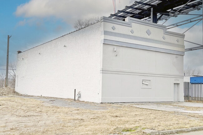

This Property Is For Sale
NEARBY LISTINGS FOR SALE OR LEASE
Property Detail
5935 Grand River Ave
12-006078-001
Mcgraws
Storebuilding
S GRAND RIVER W 7 SUB OF PT MCGRAWS SUB L10 P60 PLATS, W C R 12/89 40 X 140
X
Wayne
26163C0280E
Michigan
2025
0.13 AC
2025
Detroit West
522300
Detroit
3,800 SF
Detroit-Warren-Dearborn, MI
DEMOGRAPHICS near 5935 Grand River Ave
1 Mile
3 Mile
5 Mile
2024 Total Population
12,045
149,311
350,966
2029 Population
12,630
150,152
348,240
Pop Growth 2024-2029
+ 4.86%
+ 0.56%
(0.78%)
Average Age
40
37
37
2024 Total Households
5,068
62,663
137,066
HH Growth 2024-2029
+ 4.87%
+ 0.72%
(0.43%)
Median Household Inc
$23,118
$32,835
$35,169
Avg Household Size
2.20
2.20
2.40
2024 Avg HH Vehicles
1.00
1.00
1.00
Median Home Value
$74,208
$91,900
$94,417
Median Year Built
1947
1947
1948
Nearby Places
Map Layers
Map Styles
 Street
 Aerial
- Restaurants
- Banks
- Shops
- Fitness
- Groceries
PUBLIC TRANSPORTATION
AIRPORT
Detroit City
DRIVE
WALK
Distance
Detroit City
16 min
8.0 mi
Detroit Metro Wayne County
DRIVE
WALK
Distance
Detroit Metro Wayne County
30 min
20.0 mi
Freight Ports
Port Milwaukee
DRIVE
WALK
Distance
Port Milwaukee
375 min
282.3 mi
Nearby Properties
Address
Land Use
TOTAL SIZE
Lot Size
Zoning
Address
Land Use
TOTAL SIZE
Lot Size
Zoning
3,032,363 SF
24.24 AC
SD5
Address
Land Use
TOTAL SIZE
Lot Size
Zoning
409,438 SF
0.83 AC
B6
Address
Land Use
TOTAL SIZE
Lot Size
Zoning
1,409,416 SF
13.53 AC
R6
Address
Land Use
TOTAL SIZE
Lot Size
Zoning
873,048 SF
7.70 AC
R6
Address
Land Use
TOTAL SIZE
Lot Size
Zoning
1,017,009 SF
1.35 AC
R6
Address
Land Use
TOTAL SIZE
Lot Size
Zoning
848,598 SF
8.78 AC
SD5
Address
Land Use
TOTAL SIZE
Lot Size
Zoning
252,150 SF
2.46 AC
SD5
Address
Land Use
TOTAL SIZE
Lot Size
Zoning
185,300 SF
3.36 AC
SD5
Address
Land Use
TOTAL SIZE
Lot Size
Zoning
6,620 SF
9.43 AC
B6
Address
Land Use
TOTAL SIZE
Lot Size
Zoning
503,688 SF
Address
Land Use
TOTAL SIZE
Lot Size
Zoning
306,496 SF
1.91 AC
R6
Address
Land Use
TOTAL SIZE
Lot Size
Zoning
268,746 SF
B5
Address
Land Use
TOTAL SIZE
Lot Size
Zoning
576,286 SF
1.66 AC
B4
Address
Land Use
TOTAL SIZE
Lot Size
Zoning
328,284 SF
768.89 AC
PD
Address
Land Use
TOTAL SIZE
Lot Size
Zoning
268,114 SF
2.46 AC
B6
Address
Land Use
TOTAL SIZE
Lot Size
Zoning
246,212 SF
B5
Address
Land Use
TOTAL SIZE
Lot Size
Zoning
334,904 SF
B5
Address
Land Use
TOTAL SIZE
Lot Size
Zoning
1,017,597 SF
2.73 AC
B5
Address
Land Use
TOTAL SIZE
Lot Size
Zoning
302,517 SF
2.50 AC
B4
Address
Land Use
TOTAL SIZE
Lot Size
Zoning
627,489 SF
5.82 AC
B4
Address
Land Use
TOTAL SIZE
Lot Size
Zoning
235,468 SF
1.50 AC
B5
Address
Land Use
TOTAL SIZE
Lot Size
Zoning
210,426 SF
1.97 AC
B4
Address
Land Use
TOTAL SIZE
Lot Size
Zoning
236,576 SF
B5
Address
Land Use
TOTAL SIZE
Lot Size
Zoning
346,191 SF
0.66 AC
B5
Address
Land Use
TOTAL SIZE
Lot Size
Zoning
192,497 SF
B5
Address
Land Use
TOTAL SIZE
Lot Size
Zoning
506,450 SF
3.84 AC
B5
Address
Land Use
TOTAL SIZE
Lot Size
Zoning
596,304 SF
2.57 AC
R6
Address
Land Use
TOTAL SIZE
Lot Size
Zoning
221,506 SF
1.51 AC
B4
Address
Land Use
TOTAL SIZE
Lot Size
Zoning
199,894 SF
0.35 AC
B5
Address
Land Use
TOTAL SIZE
Lot Size
Zoning
266,016 SF
7.76 AC
PD
The World's #1 Commercial Real Estate Marketplace
Connect with us
© 2026 CoStar Group
The information above has been obtained from sources believed reliable. While we do not doubt its accuracy we have not verified it and make no guarantee, warranty or representation about it. It is your responsibility to independently confirm its accuracy and completeness. Any projections, opinions, assumptions, or estimates used are for example only and do not represent the current or future performance of the property. The value of this transaction to you depends on tax and other factors which should be evaluated by your tax, financial, and legal advisors. You and your advisors should conduct a careful, independent investigation of the property to determine to your satisfaction the suitability of the property for your needs.