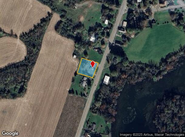
Property Record
5935 Route 281, Homer, NY 13077
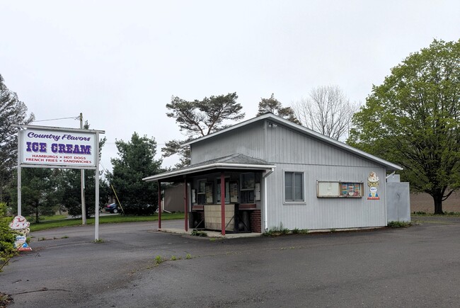

This Property Is For Sale
NEARBY LISTINGS FOR SALE OR LEASE
-
-
View all Homer listings for sale on LoopNet.com
Property Detail
5935 Route 281
113089-047-009-0001-009-000-0000
Cortland
Restaurantdrivein
New York
X
9.000
36023C0133D
0.59 AC
2025
Cortland County
2024
Syracuse
970202
Cortland, NY
400 SF
DEMOGRAPHICS near 5935 Route 281
1 Mile
3 Mile
5 Mile
2024 Total Population
559
1,694
7,027
2029 Population
535
1,630
6,761
Pop Growth 2024-2029
(4.29%)
(3.78%)
(3.79%)
Average Age
43
44
43
2024 Total Households
216
670
2,863
HH Growth 2024-2029
(4.63%)
(3.88%)
(3.95%)
Median Household Inc
$91,406
$86,562
$75,162
Avg Household Size
2.60
2.50
2.40
2024 Avg HH Vehicles
2.00
2.00
2.00
Median Home Value
$202,439
$186,595
$162,129
Median Year Built
1975
1973
1961
Nearby Places
Map Layers
Map Styles
 Street
 Aerial
- Restaurants
- Banks
- Shops
- Fitness
- Groceries
PUBLIC TRANSPORTATION
AIRPORT
Ithaca Tompkins International
DRIVE
WALK
Distance
Ithaca Tompkins International
41 min
24.9 mi
Syracuse Hancock International
DRIVE
WALK
Distance
Syracuse Hancock International
44 min
33.0 mi
Nearby Properties
Address
Land Use
TOTAL SIZE
Lot Size
Zoning
Address
Land Use
TOTAL SIZE
Lot Size
Zoning
4,388 SF
116.70 AC
Address
Land Use
TOTAL SIZE
Lot Size
Zoning
9,900 SF
2.23 AC
07 - MIXED
Address
Land Use
TOTAL SIZE
Lot Size
Zoning
6,400 SF
3.66 AC
Address
Land Use
TOTAL SIZE
Lot Size
Zoning
67.50 AC
Address
Land Use
TOTAL SIZE
Lot Size
Zoning
980 SF
16.70 AC
04 - FARM
Address
Land Use
TOTAL SIZE
Lot Size
Zoning
432 SF
17.49 AC
Address
Land Use
TOTAL SIZE
Lot Size
Zoning
Address
Land Use
TOTAL SIZE
Lot Size
Zoning
374 AC
04 - FARM
Address
Land Use
TOTAL SIZE
Lot Size
Zoning
4,352 SF
1.84 AC
Address
Land Use
TOTAL SIZE
Lot Size
Zoning
14.78 AC
06 - INDUS
Address
Land Use
TOTAL SIZE
Lot Size
Zoning
5.39 AC
Address
Land Use
TOTAL SIZE
Lot Size
Zoning
220 AC
04 - FARM
Address
Land Use
TOTAL SIZE
Lot Size
Zoning
357 AC
04 - FARM
Address
Land Use
TOTAL SIZE
Lot Size
Zoning
208.60 AC
Address
Land Use
TOTAL SIZE
Lot Size
Zoning
5,880 SF
6.40 AC
Address
Land Use
TOTAL SIZE
Lot Size
Zoning
Address
Land Use
TOTAL SIZE
Lot Size
Zoning
2,758 SF
21.60 AC
04 - FARM
Address
Land Use
TOTAL SIZE
Lot Size
Zoning
980 SF
2.10 AC
04 - FARM
Address
Land Use
TOTAL SIZE
Lot Size
Zoning
213.20 AC
Address
Land Use
TOTAL SIZE
Lot Size
Zoning
16,200 SF
60.72 AC
Address
Land Use
TOTAL SIZE
Lot Size
Zoning
2,874 SF
0.26 AC
Address
Land Use
TOTAL SIZE
Lot Size
Zoning
7,644 SF
5.49 AC
Address
Land Use
TOTAL SIZE
Lot Size
Zoning
8,664 SF
0.73 AC
Address
Land Use
TOTAL SIZE
Lot Size
Zoning
Address
Land Use
TOTAL SIZE
Lot Size
Zoning
3.12 AC
04 - FARM
Address
Land Use
TOTAL SIZE
Lot Size
Zoning
219.30 AC
04 - FARM
Address
Land Use
TOTAL SIZE
Lot Size
Zoning
7,400 SF
153.70 AC
Address
Land Use
TOTAL SIZE
Lot Size
Zoning
6,700 SF
2.24 AC
Address
Land Use
TOTAL SIZE
Lot Size
Zoning
1,658 SF
Address
Land Use
TOTAL SIZE
Lot Size
Zoning
7,236 SF
1.38 AC
The World's #1 Commercial Real Estate Marketplace
Connect with us
© 2026 CoStar Group
The information above has been obtained from sources believed reliable. While we do not doubt its accuracy we have not verified it and make no guarantee, warranty or representation about it. It is your responsibility to independently confirm its accuracy and completeness. Any projections, opinions, assumptions, or estimates used are for example only and do not represent the current or future performance of the property. The value of this transaction to you depends on tax and other factors which should be evaluated by your tax, financial, and legal advisors. You and your advisors should conduct a careful, independent investigation of the property to determine to your satisfaction the suitability of the property for your needs.