Property Record
5935 Woodland Ave, Philadelphia, PA 19143
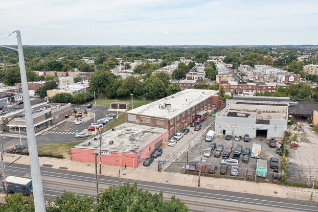
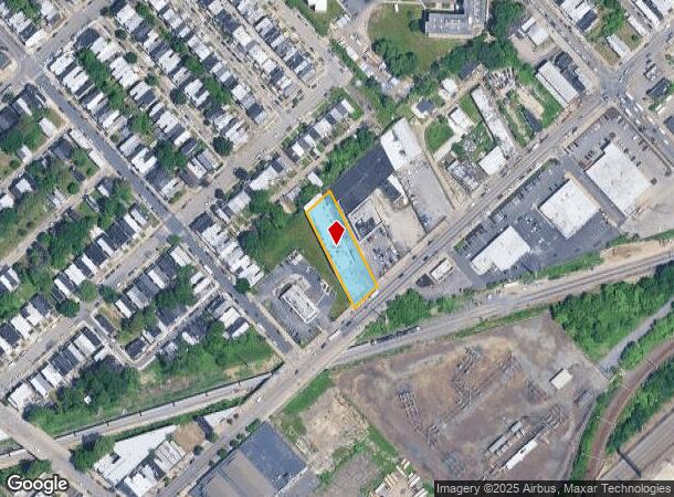
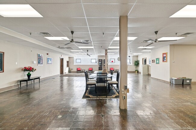
This Property Is For Sale
NEARBY LISTINGS FOR SALE OR LEASE
Property Detail
5935 Woodland Ave
884156400
1805 NE OF 60TH ST
Warehouse
Philadelphia
X
Pennsylvania
4207570186H
80
2024
0.54 AC
2026
Southwest Philly
006600
Philadelphia
30,740 SF
Philadelphia-Camden-Wilmington, PA-NJ-DE-MD
DEMOGRAPHICS near 5935 Woodland Ave
1 Mile
3 Mile
5 Mile
2024 Total Population
48,099
376,205
830,115
2029 Population
47,945
376,441
831,241
Pop Growth 2024-2029
(0.32%)
+ 0.06%
+ 0.14%
Average Age
37
37
38
2024 Total Households
17,668
148,350
349,842
HH Growth 2024-2029
(0.30%)
(0.12%)
(0.06%)
Median Household Inc
$42,683
$51,552
$66,287
Avg Household Size
2.60
2.30
2.20
2024 Avg HH Vehicles
1.00
1.00
1.00
Median Home Value
$121,271
$196,487
$265,703
Median Year Built
1947
1948
1949
Nearby Places
- Restaurants
- Banks
- Shops
- Fitness
- Groceries
PUBLIC TRANSPORTATION
TRANSIT/SUBWAY
Woodland Avenue And 60Th Street (Route 11 - Southeastern Pennsylvania Transportation Authority Rapid Transit (SEPTA Subway & Trolley))
DRIVE
WALK
Distance
Woodland Avenue And 60Th Street (Route 11 - Southeastern Pennsylvania Transportation Authority Rapid Transit (SEPTA Subway & Trolley))
0 min
1 min
0.1 mi
Woodland Avenue And 58Th Street (Route 11 - Southeastern Pennsylvania Transportation Authority Rapid Transit (SEPTA Subway & Trolley))
DRIVE
WALK
Distance
Woodland Avenue And 58Th Street (Route 11 - Southeastern Pennsylvania Transportation Authority Rapid Transit (SEPTA Subway & Trolley))
0 min
3 min
0.2 mi
Woodland Avenue And 61St Street (Route 11 - Southeastern Pennsylvania Transportation Authority Rapid Transit (SEPTA Subway & Trolley))
DRIVE
WALK
Distance
Woodland Avenue And 61St Street (Route 11 - Southeastern Pennsylvania Transportation Authority Rapid Transit (SEPTA Subway & Trolley))
0 min
3 min
0.2 mi
Kingsessing Avenue And 60Th Street (Route 13 - Southeastern Pennsylvania Transportation Authority Rapid Transit (SEPTA Subway & Trolley))
DRIVE
WALK
Distance
Kingsessing Avenue And 60Th Street (Route 13 - Southeastern Pennsylvania Transportation Authority Rapid Transit (SEPTA Subway & Trolley))
1 min
5 min
0.3 mi
Woodland Avenue And 57Th Street (Route 11 - Southeastern Pennsylvania Transportation Authority Rapid Transit (SEPTA Subway & Trolley))
DRIVE
WALK
Distance
Woodland Avenue And 57Th Street (Route 11 - Southeastern Pennsylvania Transportation Authority Rapid Transit (SEPTA Subway & Trolley))
1 min
5 min
0.3 mi
COMMUTER RAIL
49Th Street (R3 - Southeastern Pennsylvania Transportation Authority Regional Rail (SEPTA Regional Rail))
DRIVE
WALK
Distance
49Th Street (R3 - Southeastern Pennsylvania Transportation Authority Regional Rail (SEPTA Regional Rail))
3 min
1.3 mi
Angora (R3 - Southeastern Pennsylvania Transportation Authority Regional Rail (SEPTA Regional Rail))
DRIVE
WALK
Distance
Angora (R3 - Southeastern Pennsylvania Transportation Authority Regional Rail (SEPTA Regional Rail))
4 min
1.4 mi
AIRPORT
Philadelphia International
DRIVE
WALK
Distance
Philadelphia International
15 min
6.2 mi
Freight Ports
South Jersey Port
DRIVE
WALK
Distance
South Jersey Port
19 min
9.0 mi
Nearby Properties
Address
Land Use
TOTAL SIZE
Lot Size
Zoning
Address
Land Use
TOTAL SIZE
Lot Size
Zoning
1,076,400 SF
5 AC
CMX4
Address
Land Use
TOTAL SIZE
Lot Size
Zoning
319,590 SF
0.87 AC
I2
Address
Land Use
TOTAL SIZE
Lot Size
Zoning
782,208 SF
0.68 AC
CMX5
Address
Land Use
TOTAL SIZE
Lot Size
Zoning
696,920 SF
10.55 AC
SPINS
Address
Land Use
TOTAL SIZE
Lot Size
Zoning
700,000 SF
7.88 AC
CMX5
Address
Land Use
TOTAL SIZE
Lot Size
Zoning
391,440 SF
1.72 AC
SPINS
Address
Land Use
TOTAL SIZE
Lot Size
Zoning
600,523 SF
1.85 AC
CMX4
Address
Land Use
TOTAL SIZE
Lot Size
Zoning
385,000 SF
2.49 AC
SPINS
Address
Land Use
TOTAL SIZE
Lot Size
Zoning
376,874 SF
3.14 AC
SPINS
Address
Land Use
TOTAL SIZE
Lot Size
Zoning
375,500 SF
1.40 AC
CMX5
Address
Land Use
TOTAL SIZE
Lot Size
Zoning
373,040 SF
4.17 AC
SPINS
Address
Land Use
TOTAL SIZE
Lot Size
Zoning
400,000 SF
3.32 AC
CMX5
Address
Land Use
TOTAL SIZE
Lot Size
Zoning
685,000 SF
47.69 AC
CMX3
Address
Land Use
TOTAL SIZE
Lot Size
Zoning
727,272 SF
16.70 AC
I3
Address
Land Use
TOTAL SIZE
Lot Size
Zoning
1,588,163 SF
7.28 AC
SPINS
Address
Land Use
TOTAL SIZE
Lot Size
Zoning
303,750 SF
1.36 AC
SPINS
Address
Land Use
TOTAL SIZE
Lot Size
Zoning
239,760 SF
5.51 AC
SPINS
Address
Land Use
TOTAL SIZE
Lot Size
Zoning
473,400 SF
0.86 AC
CMX4
Address
Land Use
TOTAL SIZE
Lot Size
Zoning
Address
Land Use
TOTAL SIZE
Lot Size
Zoning
698,358 SF
16.79 AC
SPINS
Address
Land Use
TOTAL SIZE
Lot Size
Zoning
279,420 SF
1.21 AC
SPINS
Address
Land Use
TOTAL SIZE
Lot Size
Zoning
396,788 SF
1.62 AC
CMX5
Address
Land Use
TOTAL SIZE
Lot Size
Zoning
Address
Land Use
TOTAL SIZE
Lot Size
Zoning
354,372 SF
1 AC
CMX4
Address
Land Use
TOTAL SIZE
Lot Size
Zoning
226,650 SF
4.51 AC
CMX5
Address
Land Use
TOTAL SIZE
Lot Size
Zoning
269,171 SF
2.64 AC
SPINS
Address
Land Use
TOTAL SIZE
Lot Size
Zoning
910,000 SF
70 AC
I2
Address
Land Use
TOTAL SIZE
Lot Size
Zoning
525,469 SF
2.57 AC
CMX4
Address
Land Use
TOTAL SIZE
Lot Size
Zoning
500,000 SF
5.81 AC
CMX5
Address
Land Use
TOTAL SIZE
Lot Size
Zoning
259,691 SF
6.23 AC
SPINS
The World's #1 Commercial Real Estate Marketplace
Connect with us
© 2025 CoStar Group
The information above has been obtained from sources believed reliable. While we do not doubt its accuracy we have not verified it and make no guarantee, warranty or representation about it. It is your responsibility to independently confirm its accuracy and completeness. Any projections, opinions, assumptions, or estimates used are for example only and do not represent the current or future performance of the property. The value of this transaction to you depends on tax and other factors which should be evaluated by your tax, financial, and legal advisors. You and your advisors should conduct a careful, independent investigation of the property to determine to your satisfaction the suitability of the property for your needs.