Property Record
5939 Lewis B Puller Memorial Hwy, Mattaponi, VA 23110
NEARBY LISTINGS FOR SALE OR LEASE
-
-
View all Mattaponi listings for sale on LoopNet.com
Property Detail
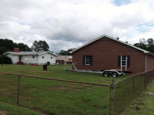
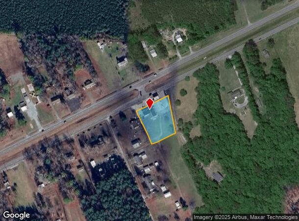
5939 Lewis B Puller Memorial Hwy
23 165X 137A
Dudleys Ferry
Storebuilding
DUDLEY'S FERRY
X
King and Queen
51101C0292F
Virginia
2024
1.25 AC
2024
King and Queen County
950500
Richmond VA
1,566 SF
DEMOGRAPHICS near 5939 Lewis B Puller Memorial Hwy
1 Mile
3 Mile
5 Mile
2024 Total Population
293
3,101
6,736
2029 Population
285
3,332
7,416
Pop Growth 2024-2029
(2.73%)
+ 7.45%
+ 10.10%
Average Age
47
42
43
2024 Total Households
134
1,258
2,639
HH Growth 2024-2029
(2.99%)
+ 6.84%
+ 9.25%
Median Household Inc
$76,875
$75,777
$77,239
Avg Household Size
2.20
2.40
2.40
2024 Avg HH Vehicles
2.00
2.00
2.00
Median Home Value
$173,529
$233,919
$245,667
Median Year Built
1963
1974
1980
Nearby Places
Map Layers
Map Styles
 Street
 Aerial
- Restaurants
- Banks
- Shops
- Fitness
- Groceries
SALE & LEASE HISTORY
LISTING DATE
SALE/LEASE

Oct 03, 2017
For Sale
Nearby Properties
Address
Land Use
TOTAL SIZE
Lot Size
Zoning
Address
Land Use
TOTAL SIZE
Lot Size
Zoning
85,500 SF
42 AC
R-1
Address
Land Use
TOTAL SIZE
Lot Size
Zoning
4,888 SF
362 AC
INDUSTRIAL
Address
Land Use
TOTAL SIZE
Lot Size
Zoning
81,780 SF
11.38 AC
MU-1
Address
Land Use
TOTAL SIZE
Lot Size
Zoning
12,960 SF
8.24 AC
M-2
Address
Land Use
TOTAL SIZE
Lot Size
Zoning
29,920 SF
0.14 AC
B-1
Address
Land Use
TOTAL SIZE
Lot Size
Zoning
4,290 SF
1.62 AC
B-1
Address
Land Use
TOTAL SIZE
Lot Size
Zoning
8,181 SF
7 AC
INDUSTRIAL
Address
Land Use
TOTAL SIZE
Lot Size
Zoning
11,732 SF
10 AC
GENERAL BU
Address
Land Use
TOTAL SIZE
Lot Size
Zoning
8,400 SF
30.50 AC
INDUSTRIAL
Address
Land Use
TOTAL SIZE
Lot Size
Zoning
8,500 SF
0.27 AC
B-1
Address
Land Use
TOTAL SIZE
Lot Size
Zoning
7,208 SF
0.13 AC
R-4
Address
Land Use
TOTAL SIZE
Lot Size
Zoning
9,224 SF
3 AC
GENERAL BU
Address
Land Use
TOTAL SIZE
Lot Size
Zoning
4,028 SF
0.18 AC
B-1
Address
Land Use
TOTAL SIZE
Lot Size
Zoning
4,473 SF
0.13 AC
B-2
Address
Land Use
TOTAL SIZE
Lot Size
Zoning
5,682 SF
0.25 AC
B-1
Address
Land Use
TOTAL SIZE
Lot Size
Zoning
3,029 SF
B-1
Address
Land Use
TOTAL SIZE
Lot Size
Zoning
9,312 SF
0.13 AC
B-2
Address
Land Use
TOTAL SIZE
Lot Size
Zoning
8,100 SF
0.88 AC
MU-1
Address
Land Use
TOTAL SIZE
Lot Size
Zoning
2 AC
GENERAL BU
Address
Land Use
TOTAL SIZE
Lot Size
Zoning
5,116 SF
1.02 AC
B-1
Address
Land Use
TOTAL SIZE
Lot Size
Zoning
8,000 SF
8.75 AC
RESIDENTIA
Address
Land Use
TOTAL SIZE
Lot Size
Zoning
3,176 SF
0.13 AC
B-2
Address
Land Use
TOTAL SIZE
Lot Size
Zoning
11,695 SF
0.13 AC
B-1
Address
Land Use
TOTAL SIZE
Lot Size
Zoning
8,742 SF
0.33 AC
R-4
Address
Land Use
TOTAL SIZE
Lot Size
Zoning
12,222 SF
3.50 AC
GENERAL BU
Address
Land Use
TOTAL SIZE
Lot Size
Zoning
3,346 SF
1.25 AC
R-1
Address
Land Use
TOTAL SIZE
Lot Size
Zoning
1,920 SF
0.75 AC
LIMITED BU
The World's #1 Commercial Real Estate Marketplace
Connect with us
© 2025 CoStar Group
The information above has been obtained from sources believed reliable. While we do not doubt its accuracy we have not verified it and make no guarantee, warranty or representation about it. It is your responsibility to independently confirm its accuracy and completeness. Any projections, opinions, assumptions, or estimates used are for example only and do not represent the current or future performance of the property. The value of this transaction to you depends on tax and other factors which should be evaluated by your tax, financial, and legal advisors. You and your advisors should conduct a careful, independent investigation of the property to determine to your satisfaction the suitability of the property for your needs.