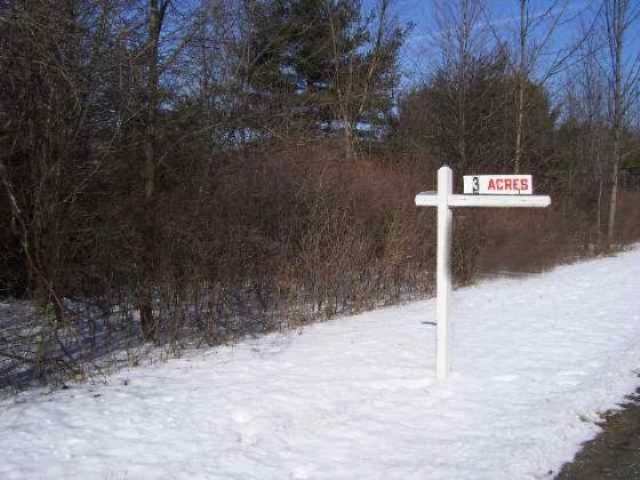
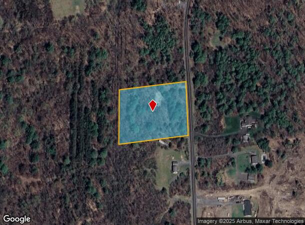
Property Record
5939 Ostrander Rd, Guilderland, NY 12084
NEARBY LISTINGS FOR SALE OR LEASE
Property Detail
5939 Ostrander Rd
013089-050-000-0002-016-072-0000
Albany
Residentialacreage
New York
X
16.072
36001C0162D
2.91 AC
2025
W Outer Albany County
2024
Albany/Schenectady/Troy
014615
Albany-Schenectady-Troy, NY
DEMOGRAPHICS near 5939 Ostrander Rd
1 Mile
3 Mile
5 Mile
2024 Total Population
145
15,882
42,294
2029 Population
143
15,853
42,139
Pop Growth 2024-2029
(1.38%)
(0.18%)
(0.37%)
Average Age
47
42
43
2024 Total Households
58
6,563
17,700
HH Growth 2024-2029
0.00%
(0.09%)
(0.28%)
Median Household Inc
$105,682
$96,634
$93,513
Avg Household Size
2.30
2.30
2.30
2024 Avg HH Vehicles
2.00
2.00
2.00
Median Home Value
$372,727
$355,147
$304,376
Median Year Built
1983
1977
1978
Nearby Places
- Restaurants
- Banks
- Shops
- Fitness
- Groceries
PUBLIC TRANSPORTATION
AIRPORT
Albany International
DRIVE
WALK
Distance
Albany International
27 min
14.2 mi
Freight Ports
Albany, NY Port
DRIVE
WALK
Distance
Albany, NY Port
28 min
14.7 mi
Nearby Properties
Address
Land Use
TOTAL SIZE
Lot Size
Zoning
Address
Land Use
TOTAL SIZE
Lot Size
Zoning
47,424 SF
37.60 AC
MR
Address
Land Use
TOTAL SIZE
Lot Size
Zoning
353,075 SF
69.50 AC
R15
Address
Land Use
TOTAL SIZE
Lot Size
Zoning
172,800 SF
209.63 AC
IN
Address
Land Use
TOTAL SIZE
Lot Size
Zoning
8,600 SF
14.80 AC
MR
Address
Land Use
TOTAL SIZE
Lot Size
Zoning
172,800 SF
272.81 AC
IN
Address
Land Use
TOTAL SIZE
Lot Size
Zoning
9,000 SF
10.32 AC
GB
Address
Land Use
TOTAL SIZE
Lot Size
Zoning
22,446 SF
11.30 AC
MR
Address
Land Use
TOTAL SIZE
Lot Size
Zoning
10,880 SF
13.50 AC
TH
Address
Land Use
TOTAL SIZE
Lot Size
Zoning
75,790 SF
19.23 AC
RO40
Address
Land Use
TOTAL SIZE
Lot Size
Zoning
161,797 SF
13.69 AC
GB
Address
Land Use
TOTAL SIZE
Lot Size
Zoning
19,968 SF
12 AC
MR
Address
Land Use
TOTAL SIZE
Lot Size
Zoning
14,436 SF
13.20 AC
MR
Address
Land Use
TOTAL SIZE
Lot Size
Zoning
131,716 SF
65.09 AC
RO40
Address
Land Use
TOTAL SIZE
Lot Size
Zoning
16,232 SF
285.90 AC
RO40
Address
Land Use
TOTAL SIZE
Lot Size
Zoning
121,137 SF
5.92 AC
PUD
Address
Land Use
TOTAL SIZE
Lot Size
Zoning
89,640 SF
6 AC
MR
Address
Land Use
TOTAL SIZE
Lot Size
Zoning
74,167 SF
8.80 AC
PUD
Address
Land Use
TOTAL SIZE
Lot Size
Zoning
7,856 SF
14.30 AC
MR
Address
Land Use
TOTAL SIZE
Lot Size
Zoning
20,630 SF
12.99 AC
MR*
Address
Land Use
TOTAL SIZE
Lot Size
Zoning
11,516 SF
131 AC
RA3
Address
Land Use
TOTAL SIZE
Lot Size
Zoning
68,000 SF
11.20 AC
TH
Address
Land Use
TOTAL SIZE
Lot Size
Zoning
7,148 SF
7.20 AC
PUD
Address
Land Use
TOTAL SIZE
Lot Size
Zoning
61,006 SF
8.10 AC
R15
Address
Land Use
TOTAL SIZE
Lot Size
Zoning
3,200 SF
231.30 AC
RA3
Address
Land Use
TOTAL SIZE
Lot Size
Zoning
87,983 SF
42.54 AC
R15
Address
Land Use
TOTAL SIZE
Lot Size
Zoning
63,740 SF
3 AC
V1
Address
Land Use
TOTAL SIZE
Lot Size
Zoning
33,176 SF
3.29 AC
R15
Address
Land Use
TOTAL SIZE
Lot Size
Zoning
6,480 SF
5.01 AC
MR
Address
Land Use
TOTAL SIZE
Lot Size
Zoning
56,592 SF
29.50 AC
R20
Address
Land Use
TOTAL SIZE
Lot Size
Zoning
189,116 SF
7.60 AC
IN
The World's #1 Commercial Real Estate Marketplace
Connect with us
© 2025 CoStar Group
The information above has been obtained from sources believed reliable. While we do not doubt its accuracy we have not verified it and make no guarantee, warranty or representation about it. It is your responsibility to independently confirm its accuracy and completeness. Any projections, opinions, assumptions, or estimates used are for example only and do not represent the current or future performance of the property. The value of this transaction to you depends on tax and other factors which should be evaluated by your tax, financial, and legal advisors. You and your advisors should conduct a careful, independent investigation of the property to determine to your satisfaction the suitability of the property for your needs.