Property Record
594 E 16Th St, Holland, MI 49423

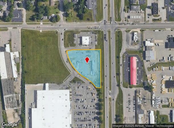
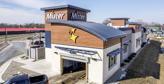
This Property Is For Sale
NEARBY LISTINGS FOR SALE OR LEASE
Property Detail
594 E 16Th St
Grand Rapids-Wyoming, MI
PART OF NE 1/4 COM AT NE SEC COR, TH N 89D 37M 15S W 94516 FT & S 0D 02M 51S W 244 FT ALG W LI US-31 TO PT OF BEG, TH CONT S
70-16-33-200-105
Ottawa
Commercialnec
Michigan
2024
2 AC
2025
Holland West
025700
West Michigan
6,492 SF
DEMOGRAPHICS near 594 E 16Th St
1 Mile
3 Mile
5 Mile
2024 Total Population
6,988
47,141
96,906
2029 Population
7,270
49,106
100,970
Pop Growth 2024-2029
+ 4.04%
+ 4.17%
+ 4.19%
Average Age
39
38
39
2024 Total Households
2,775
17,771
36,051
HH Growth 2024-2029
+ 4.18%
+ 4.32%
+ 4.33%
Median Household Inc
$57,736
$66,827
$72,710
Avg Household Size
2.30
2.40
2.60
2024 Avg HH Vehicles
2.00
2.00
2.00
Median Home Value
$199,039
$221,204
$237,120
Median Year Built
1977
1976
1983
Nearby Places
Map Layers
Map Styles
 Street
 Aerial
- Restaurants
- Banks
- Shops
- Fitness
- Groceries
PUBLIC TRANSPORTATION
COMMUTER RAIL
Holland Amtrak Station (Pere Marquette - Amtrak)
DRIVE
WALK
Distance
Holland Amtrak Station (Pere Marquette - Amtrak)
4 min
1.5 mi
AIRPORT
Gerald R Ford International
DRIVE
WALK
Distance
Gerald R Ford International
44 min
33.5 mi
Freight Ports
Port Milwaukee
DRIVE
WALK
Distance
Port Milwaukee
276 min
235.9 mi
Nearby Properties
Address
Land Use
TOTAL SIZE
Lot Size
Zoning
Address
Land Use
TOTAL SIZE
Lot Size
Zoning
1,599,294 SF
Address
Land Use
TOTAL SIZE
Lot Size
Zoning
572,832 SF
10.89 AC
PUD
Address
Land Use
TOTAL SIZE
Lot Size
Zoning
1,788,352 SF
173.33 AC
Address
Land Use
TOTAL SIZE
Lot Size
Zoning
682,378 SF
99.60 AC
NA
Address
Land Use
TOTAL SIZE
Lot Size
Zoning
662,015 SF
177 AC
SEE MAP
Address
Land Use
TOTAL SIZE
Lot Size
Zoning
198,712 SF
Address
Land Use
TOTAL SIZE
Lot Size
Zoning
630,943 SF
28.50 AC
Address
Land Use
TOTAL SIZE
Lot Size
Zoning
556,819 SF
85.45 AC
Address
Land Use
TOTAL SIZE
Lot Size
Zoning
249,051 SF
24.77 AC
LDR
Address
Land Use
TOTAL SIZE
Lot Size
Zoning
660,002 SF
32.13 AC
I-2
Address
Land Use
TOTAL SIZE
Lot Size
Zoning
218,722 SF
8.59 AC
AGR
Address
Land Use
TOTAL SIZE
Lot Size
Zoning
320,270 SF
33.25 AC
PUD
Address
Land Use
TOTAL SIZE
Lot Size
Zoning
329,784 SF
38.51 AC
I-2
Address
Land Use
TOTAL SIZE
Lot Size
Zoning
226,347 SF
19.44 AC
I-2
Address
Land Use
TOTAL SIZE
Lot Size
Zoning
674,052 SF
79.30 AC
Address
Land Use
TOTAL SIZE
Lot Size
Zoning
132,127 SF
42.69 AC
SEE MAP
Address
Land Use
TOTAL SIZE
Lot Size
Zoning
239,465 SF
Address
Land Use
TOTAL SIZE
Lot Size
Zoning
94,790 SF
1.74 AC
C-2
Address
Land Use
TOTAL SIZE
Lot Size
Zoning
58,710 SF
6.96 AC
C-2
Address
Land Use
TOTAL SIZE
Lot Size
Zoning
150,822 SF
Address
Land Use
TOTAL SIZE
Lot Size
Zoning
209,455 SF
17 AC
C-2
Address
Land Use
TOTAL SIZE
Lot Size
Zoning
177,800 SF
12.34 AC
I-2
Address
Land Use
TOTAL SIZE
Lot Size
Zoning
114,088 SF
10.79 AC
PRD
Address
Land Use
TOTAL SIZE
Lot Size
Zoning
134,490 SF
15.76 AC
C-2
Address
Land Use
TOTAL SIZE
Lot Size
Zoning
181,754 SF
13.44 AC
R3
Address
Land Use
TOTAL SIZE
Lot Size
Zoning
136,520 SF
13.55 AC
PUD
Address
Land Use
TOTAL SIZE
Lot Size
Zoning
391,842 SF
28.34 AC
Address
Land Use
TOTAL SIZE
Lot Size
Zoning
1,801 SF
23.26 AC
PUD
Address
Land Use
TOTAL SIZE
Lot Size
Zoning
228,876 SF
49.31 AC
GMU
Address
Land Use
TOTAL SIZE
Lot Size
Zoning
372,017 SF
17.60 AC
R-2
The World's #1 Commercial Real Estate Marketplace
Connect with us
© 2025 CoStar Group
The information above has been obtained from sources believed reliable. While we do not doubt its accuracy we have not verified it and make no guarantee, warranty or representation about it. It is your responsibility to independently confirm its accuracy and completeness. Any projections, opinions, assumptions, or estimates used are for example only and do not represent the current or future performance of the property. The value of this transaction to you depends on tax and other factors which should be evaluated by your tax, financial, and legal advisors. You and your advisors should conduct a careful, independent investigation of the property to determine to your satisfaction the suitability of the property for your needs.