Property Record
5940 Merrill Rd, Jacksonville, FL 32277
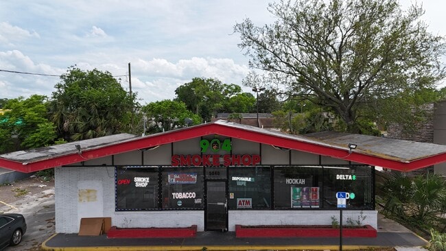


Property Detail
5940 Merrill Rd
116100-0000
25-85 09-2S-27E .239 LAKE LUCNA UNIT 7 PT TRACT C,PT E 1/2 OF NE 1/4 RECD O/R 17151-2423 BEING PARCELS A,B
Storebuilding
Duval
CCG-1
Florida
B and X Area of moderate flood hazard, usually the area between the limits of the 100-year and 500-year floods.
0.25 AC
2025
Arlington
2026
Jacksonville (Florida)
015200
Jacksonville, FL
2,946 SF
NEARBY LISTINGS FOR SALE OR LEASE
DEMOGRAPHICS near 5940 Merrill Rd
1 mile
3 mile
5 mile
2025 Total Population
15,828
83,071
196,183
2030 Population
16,646
87,981
209,344
Pop Growth 2025-2030
+ 5.17%
+ 5.91%
+ 6.71%
Average Age
37
38
38
2025 Total Households
5,783
32,368
80,412
HH Growth 2025-2030
+ 5.57%
+ 6.21%
+ 7.15%
Median Household Inc
$54,471
$57,089
$51,327
Avg Household Size
2.40
2.40
2.30
2025 Avg HH Vehicles
2.00
2.00
1.00
Median Home Value
$235,154
$265,756
$260,820
Median Year Built
1964
1973
1972
Nearby Places
Map Layers
Map Styles
 Street
 Aerial
Transit
 Traffic
 Biking
Places
Listings with unknown addresses are not visible on the map
- Restaurants
- Banks
- Shops
- Fitness
- Groceries
PUBLIC TRANSPORTATION
AIRPORT
Jacksonville International
Drive
Walk
Distance
Jacksonville International
28 min
18.0 mi
SALE & LEASE HISTORY
LISTING DATE
SALE/LEASE

Jun 12, 2019
For Sale
Jun 08, 2019
For Sale
Jul 29, 2020
For Lease
Apr 21, 2025
For Sale
Apr 12, 2017
For Lease
Apr 12, 2017
For Sale
Nearby Properties
Address
Land Use
TOTAL SIZE
Lot Size
Zoning
Address
Land Use
TOTAL SIZE
Lot Size
Zoning
1,146,106 SF
206.66 AC
PBF-2
Address
Land Use
TOTAL SIZE
Lot Size
Zoning
557,032 SF
40.06 AC
PUD
Address
Land Use
TOTAL SIZE
Lot Size
Zoning
308,517 SF
19.55 AC
PUD
Address
Land Use
TOTAL SIZE
Lot Size
Zoning
488,100 SF
35.32 AC
CRO
Address
Land Use
TOTAL SIZE
Lot Size
Zoning
323,318 SF
19.24 AC
PUD
Address
Land Use
TOTAL SIZE
Lot Size
Zoning
410,225 SF
22.11 AC
PUD
Address
Land Use
TOTAL SIZE
Lot Size
Zoning
324,687 SF
26.60 AC
RMD-D
Address
Land Use
TOTAL SIZE
Lot Size
Zoning
394,122 SF
17.19 AC
RMD-D
Address
Land Use
TOTAL SIZE
Lot Size
Zoning
300,360 SF
14.44 AC
RMD-C
Address
Land Use
TOTAL SIZE
Lot Size
Zoning
328,457 SF
23.99 AC
RMD-D
Address
Land Use
TOTAL SIZE
Lot Size
Zoning
487,388 SF
28.28 AC
PUD
Address
Land Use
TOTAL SIZE
Lot Size
Zoning
210,913 SF
10.32 AC
PUD
Address
Land Use
TOTAL SIZE
Lot Size
Zoning
184,221 SF
12.05 AC
PUD
Address
Land Use
TOTAL SIZE
Lot Size
Zoning
305,254 SF
26.77 AC
PUD
Address
Land Use
TOTAL SIZE
Lot Size
Zoning
172,591 SF
8.40 AC
CRO
Address
Land Use
TOTAL SIZE
Lot Size
Zoning
222,235 SF
14.58 AC
RMD-D
Address
Land Use
TOTAL SIZE
Lot Size
Zoning
164,330 SF
9.04 AC
PUD
Address
Land Use
TOTAL SIZE
Lot Size
Zoning
604,760 SF
11.06 AC
IW
Address
Land Use
TOTAL SIZE
Lot Size
Zoning
231,453 SF
24.55 AC
PUD
Address
Land Use
TOTAL SIZE
Lot Size
Zoning
276,782 SF
50.66 AC
IW
Address
Land Use
TOTAL SIZE
Lot Size
Zoning
229,298 SF
11.74 AC
RMD-D
Address
Land Use
TOTAL SIZE
Lot Size
Zoning
101,206 SF
9.32 AC
PUD
Address
Land Use
TOTAL SIZE
Lot Size
Zoning
252,229 SF
10.74 AC
RMD-D
Address
Land Use
TOTAL SIZE
Lot Size
Zoning
180,180 SF
11.06 AC
CRO
Address
Land Use
TOTAL SIZE
Lot Size
Zoning
211,429 SF
18.27 AC
PUD
Address
Land Use
TOTAL SIZE
Lot Size
Zoning
74,137 SF
59.05 AC
IW
Address
Land Use
TOTAL SIZE
Lot Size
Zoning
259,690 SF
17.83 AC
PUD
Address
Land Use
TOTAL SIZE
Lot Size
Zoning
34,251 SF
5.02 AC
PUD
Address
Land Use
TOTAL SIZE
Lot Size
Zoning
107,850 SF
14.52 AC
PBF-2
Address
Land Use
TOTAL SIZE
Lot Size
Zoning
156,969 SF
15.27 AC
RMD-D
The World's #1 Commercial Real Estate Marketplace
Connect with us
© 2026 CoStar Group
The information above has been obtained from sources believed reliable. While we do not doubt its accuracy we have not verified it and make no guarantee, warranty or representation about it. It is your responsibility to independently confirm its accuracy and completeness. Any projections, opinions, assumptions, or estimates used are for example only and do not represent the current or future performance of the property. The value of this transaction to you depends on tax and other factors which should be evaluated by your tax, financial, and legal advisors. You and your advisors should conduct a careful, independent investigation of the property to determine to your satisfaction the suitability of the property for your needs.