Property Record
5940 N 75Th Ave, Glendale, AZ 85303
NEARBY LISTINGS FOR SALE OR LEASE
Property Detail
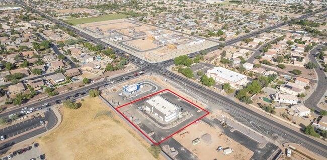
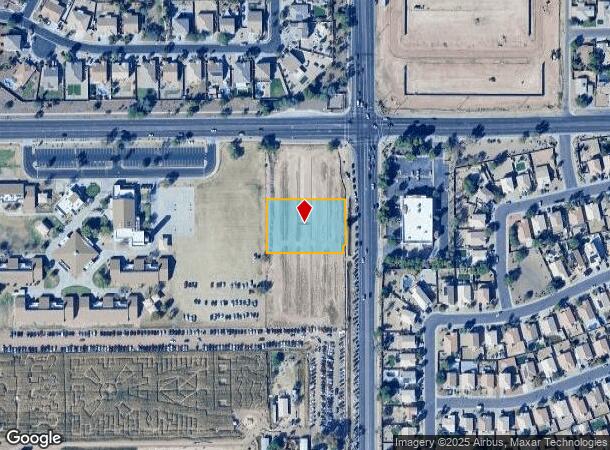
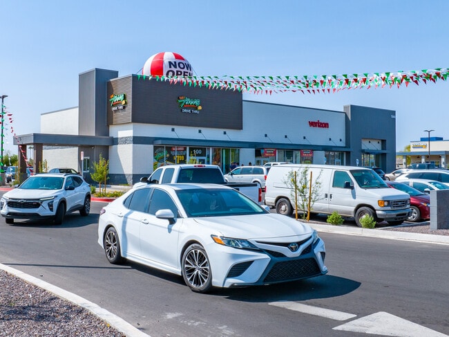
5940 N 75Th Ave
Glendale
Shops At 75Th
Phoenix
179218 SHOPS AT 75TH
Phoenix-Mesa-Chandler, AZ
Maricopa
102-07-640
Arizona
Farms
2
2025
1.04 AC
2025
DEMOGRAPHICS near 5940 N 75Th Ave
1 Mile
3 Mile
5 Mile
2024 Total Population
20,735
178,559
461,553
2029 Population
22,105
191,914
493,115
Pop Growth 2024-2029
+ 6.61%
+ 7.48%
+ 6.84%
Average Age
34
33
34
2024 Total Households
5,769
52,482
142,515
HH Growth 2024-2029
+ 6.60%
+ 7.77%
+ 6.94%
Median Household Inc
$74,381
$56,622
$56,548
Avg Household Size
3.50
3.30
3.10
2024 Avg HH Vehicles
2.00
2.00
2.00
Median Home Value
$292,276
$264,999
$251,648
Median Year Built
1990
1982
1982
Nearby Places
Map Layers
Map Styles
 Street
 Aerial
- Restaurants
- Banks
- Shops
- Fitness
- Groceries
PUBLIC TRANSPORTATION
AIRPORT
Phoenix Sky Harbor International
DRIVE
WALK
Distance
Phoenix Sky Harbor International
28 min
18.8 mi
Freight Ports
Port of San Diego
DRIVE
WALK
Distance
Port of San Diego
391 min
350.2 mi
SALE & LEASE HISTORY
LISTING DATE
SALE/LEASE

Oct 29, 2024
For Sale
Apr 11, 2025
For Sale
Nearby Properties
Address
Land Use
TOTAL SIZE
Lot Size
Zoning
Address
Land Use
TOTAL SIZE
Lot Size
Zoning
1,449,251 SF
25.30 AC
A1
Address
Land Use
TOTAL SIZE
Lot Size
Zoning
15.17 AC
Address
Land Use
TOTAL SIZE
Lot Size
Zoning
630,367 SF
13.50 AC
PAD
Address
Land Use
TOTAL SIZE
Lot Size
Zoning
74,628 SF
2.74 AC
PAD
Address
Land Use
TOTAL SIZE
Lot Size
Zoning
Address
Land Use
TOTAL SIZE
Lot Size
Zoning
13,861 SF
3.40 AC
PAD
Address
Land Use
TOTAL SIZE
Lot Size
Zoning
242,300 SF
41.79 AC
C-C
Address
Land Use
TOTAL SIZE
Lot Size
Zoning
443,840 SF
37.94 AC
PAD
Address
Land Use
TOTAL SIZE
Lot Size
Zoning
687,993 SF
48.80 AC
Address
Land Use
TOTAL SIZE
Lot Size
Zoning
285,815 SF
37.17 AC
R-6
Address
Land Use
TOTAL SIZE
Lot Size
Zoning
348,753 SF
19.36 AC
R-6
Address
Land Use
TOTAL SIZE
Lot Size
Zoning
533,718 SF
36.10 AC
PAD
Address
Land Use
TOTAL SIZE
Lot Size
Zoning
926 SF
37.32 AC
I-1
Address
Land Use
TOTAL SIZE
Lot Size
Zoning
629,928 SF
41.37 AC
Address
Land Use
TOTAL SIZE
Lot Size
Zoning
258,097 SF
32.53 AC
AG
Address
Land Use
TOTAL SIZE
Lot Size
Zoning
603,148 SF
13.63 AC
PAD
Address
Land Use
TOTAL SIZE
Lot Size
Zoning
135,052 SF
5.52 AC
PAD
Address
Land Use
TOTAL SIZE
Lot Size
Zoning
310,295 SF
9.32 AC
Address
Land Use
TOTAL SIZE
Lot Size
Zoning
342,527 SF
16.52 AC
PAD
Address
Land Use
TOTAL SIZE
Lot Size
Zoning
330,321 SF
3.85 AC
PAD
Address
Land Use
TOTAL SIZE
Lot Size
Zoning
637,538 SF
9.74 AC
Address
Land Use
TOTAL SIZE
Lot Size
Zoning
334,769 SF
12.01 AC
Address
Land Use
TOTAL SIZE
Lot Size
Zoning
4,742 SF
1.18 AC
PAD
Address
Land Use
TOTAL SIZE
Lot Size
Zoning
262,609 SF
18.96 AC
I-1
Address
Land Use
TOTAL SIZE
Lot Size
Zoning
200,998 SF
0.06 AC
C-C
Address
Land Use
TOTAL SIZE
Lot Size
Zoning
1.05 AC
Address
Land Use
TOTAL SIZE
Lot Size
Zoning
409,017 SF
14.30 AC
Address
Land Use
TOTAL SIZE
Lot Size
Zoning
187,309 SF
19.99 AC
R-6
Address
Land Use
TOTAL SIZE
Lot Size
Zoning
131,031 SF
26.44 AC
R-43
Address
Land Use
TOTAL SIZE
Lot Size
Zoning
321,976 SF
13 AC
R-43
The World's #1 Commercial Real Estate Marketplace
Connect with us
© 2026 CoStar Group
The information above has been obtained from sources believed reliable. While we do not doubt its accuracy we have not verified it and make no guarantee, warranty or representation about it. It is your responsibility to independently confirm its accuracy and completeness. Any projections, opinions, assumptions, or estimates used are for example only and do not represent the current or future performance of the property. The value of this transaction to you depends on tax and other factors which should be evaluated by your tax, financial, and legal advisors. You and your advisors should conduct a careful, independent investigation of the property to determine to your satisfaction the suitability of the property for your needs.