Property Record
5941 River Rd, Cincinnati, OH 45233
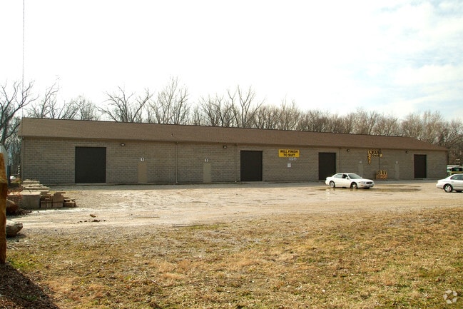

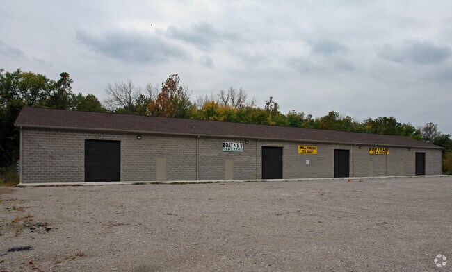
Property Detail
5941 River Rd
162-0004-0017
SS RIVER RD 0.921 ACR1 T3 S29 & 35
Warehouse
Hamilton
RFC
Ohio
AE The base floodplain where base flood elevations are provided. AE Zones are now used on new format FIRMs instead of A1-A30 Zones.
0.92 AC
2025
West
2025
Cincinnati/Dayton
010400
Cincinnati, OH-KY-IN
NEARBY LISTINGS FOR SALE OR LEASE
DEMOGRAPHICS near 5941 River Rd
1 mile
3 mile
5 mile
2025 Total Population
2,460
31,134
119,578
2030 Population
2,480
31,714
120,921
Pop Growth 2025-2030
+ 0.81%
+ 1.86%
+ 1.12%
Average Age
40
41
40
2025 Total Households
871
11,228
45,943
HH Growth 2025-2030
+ 0.57%
+ 1.84%
+ 0.99%
Median Household Inc
$88,668
$102,193
$79,134
Avg Household Size
2.60
2.60
2.50
2025 Avg HH Vehicles
2.00
2.00
2.00
Median Home Value
$250,261
$272,159
$233,815
Median Year Built
1969
1976
1968
Nearby Places
Map Layers
Map Styles
 Street
 Aerial
Transit
 Traffic
 Biking
Places
Listings with unknown addresses are not visible on the map
- Restaurants
- Banks
- Shops
- Fitness
- Groceries
PUBLIC TRANSPORTATION
COMMUTER RAIL
Drive
Walk
Distance
19 min
10.0 mi
AIRPORT
Cincinnati/Northern Kentucky International
Drive
Walk
Distance
Cincinnati/Northern Kentucky International
35 min
8.0 mi
SALE & LEASE HISTORY
LISTING DATE
SALE/LEASE

Sep 06, 2017
For Sale
Mar 16, 2018
For Lease
Mar 16, 2018
For Sale
Nearby Properties
Address
Land Use
TOTAL SIZE
Lot Size
Zoning
Address
Land Use
TOTAL SIZE
Lot Size
Zoning
127,712 SF
185 AC
Address
Land Use
TOTAL SIZE
Lot Size
Zoning
Address
Land Use
TOTAL SIZE
Lot Size
Zoning
Address
Land Use
TOTAL SIZE
Lot Size
Zoning
Address
Land Use
TOTAL SIZE
Lot Size
Zoning
Address
Land Use
TOTAL SIZE
Lot Size
Zoning
Address
Land Use
TOTAL SIZE
Lot Size
Zoning
39.05 AC
Address
Land Use
TOTAL SIZE
Lot Size
Zoning
520,320 SF
31.99 AC
Address
Land Use
TOTAL SIZE
Lot Size
Zoning
48.90 AC
Address
Land Use
TOTAL SIZE
Lot Size
Zoning
21.76 AC
Address
Land Use
TOTAL SIZE
Lot Size
Zoning
520,000 SF
26.09 AC
Address
Land Use
TOTAL SIZE
Lot Size
Zoning
177,092 SF
8.64 AC
Address
Land Use
TOTAL SIZE
Lot Size
Zoning
26.27 AC
Address
Land Use
TOTAL SIZE
Lot Size
Zoning
38.97 AC
Address
Land Use
TOTAL SIZE
Lot Size
Zoning
605,850 SF
29.71 AC
Address
Land Use
TOTAL SIZE
Lot Size
Zoning
713,360 SF
50.53 AC
Address
Land Use
TOTAL SIZE
Lot Size
Zoning
522,500 SF
25.10 AC
Address
Land Use
TOTAL SIZE
Lot Size
Zoning
3.90 AC
RFC
Address
Land Use
TOTAL SIZE
Lot Size
Zoning
26.62 AC
Address
Land Use
TOTAL SIZE
Lot Size
Zoning
460,200 SF
28.39 AC
Address
Land Use
TOTAL SIZE
Lot Size
Zoning
25.80 AC
Address
Land Use
TOTAL SIZE
Lot Size
Zoning
525,000 SF
28.84 AC
Address
Land Use
TOTAL SIZE
Lot Size
Zoning
493,680 SF
25 AC
Address
Land Use
TOTAL SIZE
Lot Size
Zoning
458,800 SF
49.35 AC
Address
Land Use
TOTAL SIZE
Lot Size
Zoning
Address
Land Use
TOTAL SIZE
Lot Size
Zoning
30.43 AC
AA
Address
Land Use
TOTAL SIZE
Lot Size
Zoning
426,420 SF
20.59 AC
Address
Land Use
TOTAL SIZE
Lot Size
Zoning
396,000 SF
24 AC
Address
Land Use
TOTAL SIZE
Lot Size
Zoning
136,000 SF
20.52 AC
Address
Land Use
TOTAL SIZE
Lot Size
Zoning
The World's #1 Commercial Real Estate Marketplace
Connect with us
© 2026 CoStar Group
The information above has been obtained from sources believed reliable. While we do not doubt its accuracy we have not verified it and make no guarantee, warranty or representation about it. It is your responsibility to independently confirm its accuracy and completeness. Any projections, opinions, assumptions, or estimates used are for example only and do not represent the current or future performance of the property. The value of this transaction to you depends on tax and other factors which should be evaluated by your tax, financial, and legal advisors. You and your advisors should conduct a careful, independent investigation of the property to determine to your satisfaction the suitability of the property for your needs.