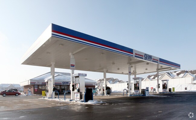
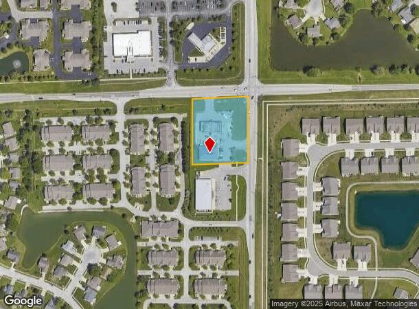
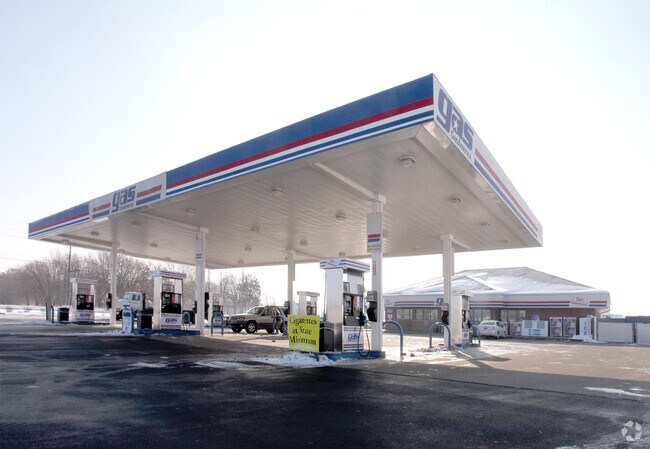
Property Record
5945 E Stop 11 Rd, Indianapolis, IN 46237
NEARBY LISTINGS FOR SALE OR LEASE
Property Detail
5945 E Stop 11 Rd
49-15-22-112-145.000-300
PT NE1/4 NE1/4 S22 T14 R4 BEG NE COR S 309.81 W270.05 N 309.81 E 270.05 TO BEG 1.921AC(1.666AC TAX)
Servicestationmarket
Marion
X
Indiana
18081C0039E
1.67 AC
2023
Beech Grove/SE County
2024
Indianapolis
390405
Indianapolis-Carmel-Anderson, IN
4,000 SF
DEMOGRAPHICS near 5945 E Stop 11 Rd
1 Mile
3 Mile
5 Mile
2024 Total Population
9,334
63,470
164,827
2029 Population
9,176
63,235
166,136
Pop Growth 2024-2029
(1.69%)
(0.37%)
+ 0.79%
Average Age
38
38
38
2024 Total Households
3,643
24,378
64,204
HH Growth 2024-2029
(1.65%)
(0.23%)
+ 0.89%
Median Household Inc
$90,907
$76,116
$70,241
Avg Household Size
2.50
2.50
2.50
2024 Avg HH Vehicles
2.00
2.00
2.00
Median Home Value
$208,003
$213,205
$207,293
Median Year Built
1998
1992
1986
Nearby Places
- Restaurants
- Banks
- Shops
- Fitness
- Groceries
PUBLIC TRANSPORTATION
AIRPORT
Indianapolis International
DRIVE
WALK
Distance
Indianapolis International
36 min
21.8 mi
Freight Ports
Port of Toledo
DRIVE
WALK
Distance
Port of Toledo
279 min
233.2 mi
Nearby Properties
Address
Land Use
TOTAL SIZE
Lot Size
Zoning
Address
Land Use
TOTAL SIZE
Lot Size
Zoning
31,217 SF
105.06 AC
ZO01
Address
Land Use
TOTAL SIZE
Lot Size
Zoning
10,540 SF
49.19 AC
ZO01
Address
Land Use
TOTAL SIZE
Lot Size
Zoning
670,880 SF
43.43 AC
Address
Land Use
TOTAL SIZE
Lot Size
Zoning
5,846 SF
43.64 AC
ZO01
Address
Land Use
TOTAL SIZE
Lot Size
Zoning
420,084 SF
23.83 AC
Address
Land Use
TOTAL SIZE
Lot Size
Zoning
3,586 SF
30.28 AC
ZO01
Address
Land Use
TOTAL SIZE
Lot Size
Zoning
493,560 SF
31.39 AC
Address
Land Use
TOTAL SIZE
Lot Size
Zoning
511,680 SF
37.57 AC
Address
Land Use
TOTAL SIZE
Lot Size
Zoning
667,500 SF
33.46 AC
Address
Land Use
TOTAL SIZE
Lot Size
Zoning
5,576 SF
14.15 AC
ZO01
Address
Land Use
TOTAL SIZE
Lot Size
Zoning
81,996 SF
8.56 AC
Address
Land Use
TOTAL SIZE
Lot Size
Zoning
4,970 SF
24.77 AC
Address
Land Use
TOTAL SIZE
Lot Size
Zoning
470,000 SF
22.75 AC
Address
Land Use
TOTAL SIZE
Lot Size
Zoning
181,458 SF
6 AC
Address
Land Use
TOTAL SIZE
Lot Size
Zoning
6,786 SF
45.81 AC
Address
Land Use
TOTAL SIZE
Lot Size
Zoning
273,000 SF
22.28 AC
Address
Land Use
TOTAL SIZE
Lot Size
Zoning
1,362 SF
6.66 AC
ZO01
Address
Land Use
TOTAL SIZE
Lot Size
Zoning
612,000 SF
31.01 AC
Address
Land Use
TOTAL SIZE
Lot Size
Zoning
21,784 SF
30.75 AC
ZO01
Address
Land Use
TOTAL SIZE
Lot Size
Zoning
331,200 SF
23.40 AC
Address
Land Use
TOTAL SIZE
Lot Size
Zoning
5,401 SF
21.94 AC
ZO01
Address
Land Use
TOTAL SIZE
Lot Size
Zoning
2,911 SF
24.62 AC
ZO01
Address
Land Use
TOTAL SIZE
Lot Size
Zoning
4,722 SF
25.71 AC
Address
Land Use
TOTAL SIZE
Lot Size
Zoning
11,868 SF
15.48 AC
ZO01
Address
Land Use
TOTAL SIZE
Lot Size
Zoning
110,598 SF
22.82 AC
ZO01
Address
Land Use
TOTAL SIZE
Lot Size
Zoning
232,156 SF
23.19 AC
Address
Land Use
TOTAL SIZE
Lot Size
Zoning
99,178 SF
18.04 AC
Address
Land Use
TOTAL SIZE
Lot Size
Zoning
155,088 SF
20.85 AC
ZO01
Address
Land Use
TOTAL SIZE
Lot Size
Zoning
241,800 SF
16.19 AC
Address
Land Use
TOTAL SIZE
Lot Size
Zoning
2,320 SF
7.92 AC
ZO01
The World's #1 Commercial Real Estate Marketplace
Connect with us
© 2025 CoStar Group
The information above has been obtained from sources believed reliable. While we do not doubt its accuracy we have not verified it and make no guarantee, warranty or representation about it. It is your responsibility to independently confirm its accuracy and completeness. Any projections, opinions, assumptions, or estimates used are for example only and do not represent the current or future performance of the property. The value of this transaction to you depends on tax and other factors which should be evaluated by your tax, financial, and legal advisors. You and your advisors should conduct a careful, independent investigation of the property to determine to your satisfaction the suitability of the property for your needs.