Property Record
595 Jackson Rd, Atco, NJ 08004
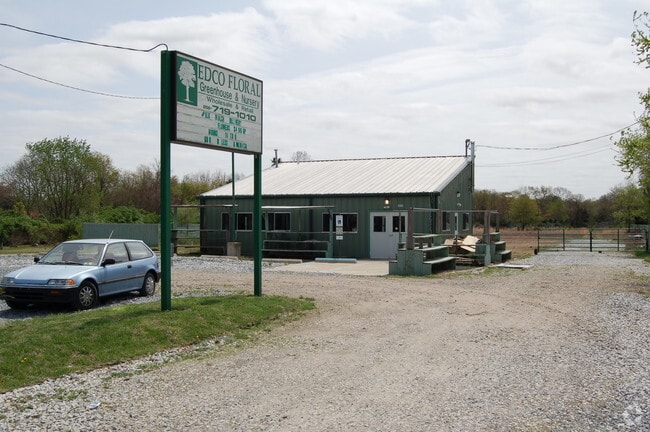

Property Detail
595 Jackson Rd
35-02801-0000-00011
ADDITIONAL LOTS: FREEDOM LAWN CARE/FACILITY NAME: GARAGE
Commercialnec
Camden
RNB
New Jersey
B and X Area of moderate flood hazard, usually the area between the limits of the 100-year and 500-year floods.
11
2025
2.07 AC
2025
South Camden County
608901
Philadelphia
1,200 SF
Philadelphia-Camden-Wilmington, PA-NJ-DE-MD
NEARBY LISTINGS FOR SALE OR LEASE
-
-
View all Atco listings for sale on LoopNet.com
DEMOGRAPHICS near 595 Jackson Rd
1 mile
3 mile
5 mile
2025 Total Population
2,814
17,388
45,155
2030 Population
2,874
17,841
46,309
Pop Growth 2025-2030
+ 2.13%
+ 2.61%
+ 2.56%
Average Age
43
42
43
2025 Total Households
957
6,456
16,726
HH Growth 2025-2030
+ 2.19%
+ 2.79%
+ 2.71%
Median Household Inc
$117,253
$112,064
$113,511
Avg Household Size
2.70
2.60
2.60
2025 Avg HH Vehicles
2.00
2.00
2.00
Median Home Value
$284,978
$306,997
$345,097
Median Year Built
1975
1979
1978
Nearby Places
Map Layers
Map Styles
 Street
 Aerial
Transit
 Traffic
 Biking
Places
Listings with unknown addresses are not visible on the map
- Restaurants
- Banks
- Shops
- Fitness
- Groceries
PUBLIC TRANSPORTATION
COMMUTER RAIL
Atco (Atlantic City Line - NJ Transit Commuter Rail (NJ Transit))
Drive
Walk
Distance
Atco (Atlantic City Line - NJ Transit Commuter Rail (NJ Transit))
6 min
3.5 mi
Lindenwold (Njt) (Atlantic City Line - NJ Transit Commuter Rail (NJ Transit))
Drive
Walk
Distance
Lindenwold (Njt) (Atlantic City Line - NJ Transit Commuter Rail (NJ Transit))
13 min
9.6 mi
AIRPORT
Philadelphia International
Drive
Walk
Distance
Philadelphia International
43 min
28.3 mi
Atlantic City International
Drive
Walk
Distance
Atlantic City International
62 min
33.1 mi
Freight Ports
Broadway Terminal - Pier 5
Drive
Walk
Distance
Broadway Terminal - Pier 5
27 min
19.8 mi
Nearby Properties
Address
Land Use
TOTAL SIZE
Lot Size
Zoning
Address
Land Use
TOTAL SIZE
Lot Size
Zoning
4,480 SF
88.36 AC
PR4
Address
Land Use
TOTAL SIZE
Lot Size
Zoning
27.18 AC
PR4
Address
Land Use
TOTAL SIZE
Lot Size
Zoning
22.93 AC
PC-2
Address
Land Use
TOTAL SIZE
Lot Size
Zoning
14.10 AC
RD-1
Address
Land Use
TOTAL SIZE
Lot Size
Zoning
8.56 AC
PARC
Address
Land Use
TOTAL SIZE
Lot Size
Zoning
5.06 AC
PF
Address
Land Use
TOTAL SIZE
Lot Size
Zoning
15.84 AC
RPF
Address
Land Use
TOTAL SIZE
Lot Size
Zoning
23.77 AC
RPF
Address
Land Use
TOTAL SIZE
Lot Size
Zoning
7.07 AC
PF
Address
Land Use
TOTAL SIZE
Lot Size
Zoning
1,341 SF
1.98 AC
PHB
Address
Land Use
TOTAL SIZE
Lot Size
Zoning
Address
Land Use
TOTAL SIZE
Lot Size
Zoning
38.85 AC
PHB
Address
Land Use
TOTAL SIZE
Lot Size
Zoning
1.64 AC
INS
Address
Land Use
TOTAL SIZE
Lot Size
Zoning
18,934 SF
5.99 AC
C2RG
Address
Land Use
TOTAL SIZE
Lot Size
Zoning
21,116 SF
4.67 AC
PC2
Address
Land Use
TOTAL SIZE
Lot Size
Zoning
2.23 AC
Address
Land Use
TOTAL SIZE
Lot Size
Zoning
9,900 SF
154 AC
RPF
Address
Land Use
TOTAL SIZE
Lot Size
Zoning
14,594 SF
1.67 AC
PHB
Address
Land Use
TOTAL SIZE
Lot Size
Zoning
5.76 AC
PHB
Address
Land Use
TOTAL SIZE
Lot Size
Zoning
73.98 AC
RGD2
Address
Land Use
TOTAL SIZE
Lot Size
Zoning
4,246 SF
10 AC
NB
Address
Land Use
TOTAL SIZE
Lot Size
Zoning
34,492 SF
9.51 AC
I1
Address
Land Use
TOTAL SIZE
Lot Size
Zoning
53.49 AC
PI
Address
Land Use
TOTAL SIZE
Lot Size
Zoning
12,288 SF
4.67 AC
R2
Address
Land Use
TOTAL SIZE
Lot Size
Zoning
2.29 AC
Address
Land Use
TOTAL SIZE
Lot Size
Zoning
2.50 AC
RD-2
Address
Land Use
TOTAL SIZE
Lot Size
Zoning
6,875 SF
58.49 AC
PPE
Address
Land Use
TOTAL SIZE
Lot Size
Zoning
249 AC
FW
Address
Land Use
TOTAL SIZE
Lot Size
Zoning
2.76 AC
R2
Address
Land Use
TOTAL SIZE
Lot Size
Zoning
10,430 SF
5.59 AC
C2
The World's #1 Commercial Real Estate Marketplace
Connect with us
© 2026 CoStar Group
The information above has been obtained from sources believed reliable. While we do not doubt its accuracy we have not verified it and make no guarantee, warranty or representation about it. It is your responsibility to independently confirm its accuracy and completeness. Any projections, opinions, assumptions, or estimates used are for example only and do not represent the current or future performance of the property. The value of this transaction to you depends on tax and other factors which should be evaluated by your tax, financial, and legal advisors. You and your advisors should conduct a careful, independent investigation of the property to determine to your satisfaction the suitability of the property for your needs.