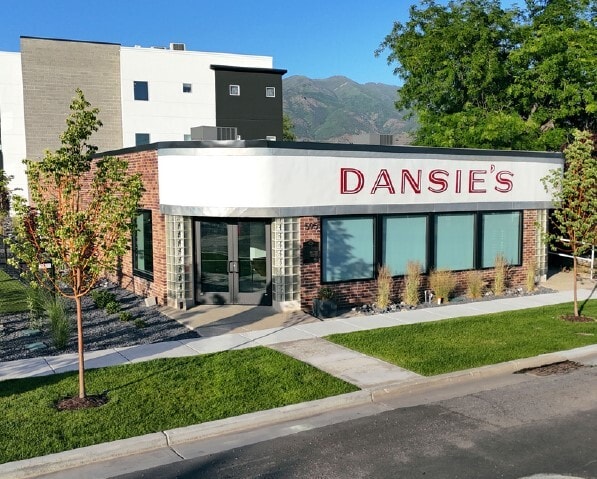
Property Record
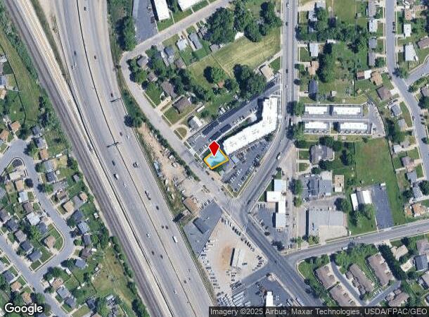
595 S Main St, Layton, UT 84041
NEARBY LISTINGS FOR SALE OR LEASE
Property Detail
595 S Main St
Salt Lake City
Dansie Market Subdivision
Ogden-Clearfield, UT
ALL OF LOT 101, DANSIE MARKET SUBDIVISION. CONT. 0.10000 ACRES
11-900-0101
Davis
Storebuilding
Utah
2025
101
2025
0.10 AC
126001
Davis/Weber Counties
3,439 SF
DEMOGRAPHICS near 595 S Main St
1 Mile
3 Mile
5 Mile
2024 Total Population
13,436
86,484
168,009
2029 Population
14,078
91,469
178,608
Pop Growth 2024-2029
+ 4.78%
+ 5.76%
+ 6.31%
Average Age
35
35
35
2024 Total Households
4,374
26,465
51,525
HH Growth 2024-2029
+ 4.78%
+ 5.73%
+ 6.42%
Median Household Inc
$80,658
$93,510
$93,830
Avg Household Size
3.00
3.20
3.20
2024 Avg HH Vehicles
2.00
2.00
2.00
Median Home Value
$368,756
$454,351
$445,123
Median Year Built
1990
1991
1994
Nearby Places
Map Layers
Map Styles
 Street
 Aerial
- Restaurants
- Banks
- Shops
- Fitness
- Groceries
PUBLIC TRANSPORTATION
TRANSIT/SUBWAY
Layton (FrontRunner North - Utah Transit Authority (UTA))
DRIVE
WALK
Distance
Layton (FrontRunner North - Utah Transit Authority (UTA))
3 min
18 min
0.9 mi
COMMUTER RAIL
Layton (FrontRunner North - Utah Transit Authority (UTA))
DRIVE
WALK
Distance
Layton (FrontRunner North - Utah Transit Authority (UTA))
3 min
17 min
0.9 mi
Clearfield (FrontRunner North - Utah Transit Authority (UTA))
DRIVE
WALK
Distance
Clearfield (FrontRunner North - Utah Transit Authority (UTA))
9 min
4.8 mi
AIRPORT
Salt Lake City International
DRIVE
WALK
Distance
Salt Lake City International
33 min
25.9 mi
Nearby Properties
Address
Land Use
TOTAL SIZE
Lot Size
Zoning
Address
Land Use
TOTAL SIZE
Lot Size
Zoning
346,223 SF
36.29 AC
BRP
Address
Land Use
TOTAL SIZE
Lot Size
Zoning
17,930 SF
17.08 AC
RM1
Address
Land Use
TOTAL SIZE
Lot Size
Zoning
102,978 SF
6.42 AC
Address
Land Use
TOTAL SIZE
Lot Size
Zoning
100,348 SF
21.75 AC
R18
Address
Land Use
TOTAL SIZE
Lot Size
Zoning
67,233 SF
32.52 AC
A1
Address
Land Use
TOTAL SIZE
Lot Size
Zoning
16,184 SF
23.31 AC
PU
Address
Land Use
TOTAL SIZE
Lot Size
Zoning
79,285 SF
0.01 AC
BRP
Address
Land Use
TOTAL SIZE
Lot Size
Zoning
1,484 SF
10.34 AC
Address
Land Use
TOTAL SIZE
Lot Size
Zoning
94,532 SF
7.07 AC
Address
Land Use
TOTAL SIZE
Lot Size
Zoning
4,281 SF
16.55 AC
RM1
Address
Land Use
TOTAL SIZE
Lot Size
Zoning
147,675 SF
11.25 AC
C-H
Address
Land Use
TOTAL SIZE
Lot Size
Zoning
455,336 SF
22.93 AC
Address
Land Use
TOTAL SIZE
Lot Size
Zoning
111,724 SF
10.72 AC
RA
Address
Land Use
TOTAL SIZE
Lot Size
Zoning
67,536 SF
13.16 AC
LI
Address
Land Use
TOTAL SIZE
Lot Size
Zoning
2,373 SF
6.63 AC
RM2PRUD
Address
Land Use
TOTAL SIZE
Lot Size
Zoning
104,342 SF
18.54 AC
M2
Address
Land Use
TOTAL SIZE
Lot Size
Zoning
61,926 SF
40.43 AC
PU
Address
Land Use
TOTAL SIZE
Lot Size
Zoning
38,832 SF
6.82 AC
CP2
Address
Land Use
TOTAL SIZE
Lot Size
Zoning
140,364 SF
6.47 AC
RH
Address
Land Use
TOTAL SIZE
Lot Size
Zoning
218,896 SF
2.76 AC
MUTOD
Address
Land Use
TOTAL SIZE
Lot Size
Zoning
119,988 SF
10.63 AC
LI
Address
Land Use
TOTAL SIZE
Lot Size
Zoning
1,679 SF
7.49 AC
RM2
Address
Land Use
TOTAL SIZE
Lot Size
Zoning
176,970 SF
13.58 AC
CP3
Address
Land Use
TOTAL SIZE
Lot Size
Zoning
72,750 SF
13.09 AC
A1
Address
Land Use
TOTAL SIZE
Lot Size
Zoning
72,750 SF
12.82 AC
BRP
Address
Land Use
TOTAL SIZE
Lot Size
Zoning
10,412 SF
12.68 AC
CP1
Address
Land Use
TOTAL SIZE
Lot Size
Zoning
143,836 SF
3.36 AC
B-RP
Address
Land Use
TOTAL SIZE
Lot Size
Zoning
312,601 SF
13.30 AC
R18
Address
Land Use
TOTAL SIZE
Lot Size
Zoning
220,887 SF
12.17 AC
CH
Address
Land Use
TOTAL SIZE
Lot Size
Zoning
61,864 SF
11.66 AC
The World's #1 Commercial Real Estate Marketplace
Connect with us
© 2025 CoStar Group
The information above has been obtained from sources believed reliable. While we do not doubt its accuracy we have not verified it and make no guarantee, warranty or representation about it. It is your responsibility to independently confirm its accuracy and completeness. Any projections, opinions, assumptions, or estimates used are for example only and do not represent the current or future performance of the property. The value of this transaction to you depends on tax and other factors which should be evaluated by your tax, financial, and legal advisors. You and your advisors should conduct a careful, independent investigation of the property to determine to your satisfaction the suitability of the property for your needs.