Property Record
5950 W 4700 S, Salt Lake City, UT 84118
This Property Is For Sale
NEARBY LISTINGS FOR SALE OR LEASE
Property Detail
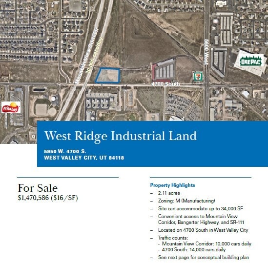
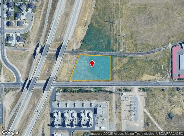
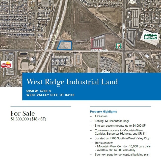
5950 W 4700 S
Salt Lake City, UT
BEG N 89^5020 E 656.51 FT & N 0^01 W 44.50 FT FR S 1/4 COR SEC 2, T2S, R2W, SLM; NELY ALG 7920 FT RADIUS CURVE TO L, 266.96 FT (CHD N 20^5947 E); S 87^1746 E 314 FT; S 0^01 E 233.25 FT; S 89^5020 W 409.37 FT TO BEG.
20-02-451-007-0000
Salt Lake
Industrialacreage
Utah
2023
2.01 AC
2025
West Valley/Lake Park
113545
Salt Lake City
DEMOGRAPHICS near 5950 W 4700 S
1 Mile
3 Mile
5 Mile
2024 Total Population
11,870
132,007
284,176
2029 Population
11,789
131,890
287,401
Pop Growth 2024-2029
(0.68%)
(0.09%)
+ 1.13%
Average Age
34
35
35
2024 Total Households
2,971
35,881
82,483
HH Growth 2024-2029
(0.98%)
(0.29%)
+ 1.11%
Median Household Inc
$95,264
$83,460
$80,620
Avg Household Size
3.80
3.50
3.30
2024 Avg HH Vehicles
3.00
3.00
2.00
Median Home Value
$358,477
$337,840
$356,919
Median Year Built
1989
1981
1986
Nearby Places
Map Layers
Map Styles
 Street
 Aerial
- Restaurants
- Banks
- Shops
- Fitness
- Groceries
PUBLIC TRANSPORTATION
AIRPORT
Salt Lake City International
DRIVE
WALK
Distance
Salt Lake City International
16 min
10.7 mi
Freight Ports
Port of Stockton
DRIVE
WALK
Distance
Port of Stockton
711 min
693.2 mi
Nearby Properties
Address
Land Use
TOTAL SIZE
Lot Size
Zoning
Address
Land Use
TOTAL SIZE
Lot Size
Zoning
1,113,459 SF
80.09 AC
M
Address
Land Use
TOTAL SIZE
Lot Size
Zoning
613,674 SF
1,309.05 AC
M
Address
Land Use
TOTAL SIZE
Lot Size
Zoning
329,306 SF
14.67 AC
5005
Address
Land Use
TOTAL SIZE
Lot Size
Zoning
432,730 SF
13.03 AC
R-M
Address
Land Use
TOTAL SIZE
Lot Size
Zoning
187,717 SF
15.02 AC
R-M
Address
Land Use
TOTAL SIZE
Lot Size
Zoning
250,027 SF
8.46 AC
PF
Address
Land Use
TOTAL SIZE
Lot Size
Zoning
186,337 SF
20 AC
1107
Address
Land Use
TOTAL SIZE
Lot Size
Zoning
297,972 SF
45.67 AC
M
Address
Land Use
TOTAL SIZE
Lot Size
Zoning
72 AC
2000
Address
Land Use
TOTAL SIZE
Lot Size
Zoning
131,500 SF
75.92 AC
R-1-10
Address
Land Use
TOTAL SIZE
Lot Size
Zoning
71,093 SF
29.58 AC
PF
Address
Land Use
TOTAL SIZE
Lot Size
Zoning
281,172 SF
12.91 AC
MI
Address
Land Use
TOTAL SIZE
Lot Size
Zoning
244,871 SF
14.53 AC
4144
Address
Land Use
TOTAL SIZE
Lot Size
Zoning
369,305 SF
11.19 AC
C - 2
Address
Land Use
TOTAL SIZE
Lot Size
Zoning
350,675 SF
36.41 AC
M
Address
Land Use
TOTAL SIZE
Lot Size
Zoning
342.97 AC
M
Address
Land Use
TOTAL SIZE
Lot Size
Zoning
12,118 SF
9.86 AC
RM
Address
Land Use
TOTAL SIZE
Lot Size
Zoning
95,998 SF
9.46 AC
1107
Address
Land Use
TOTAL SIZE
Lot Size
Zoning
391,140 SF
17.41 AC
M
Address
Land Use
TOTAL SIZE
Lot Size
Zoning
171,937 SF
24.21 AC
R-1-8
Address
Land Use
TOTAL SIZE
Lot Size
Zoning
211,058 SF
21.71 AC
C-2
Address
Land Use
TOTAL SIZE
Lot Size
Zoning
178,750 SF
9.94 AC
M-1
Address
Land Use
TOTAL SIZE
Lot Size
Zoning
211,162 SF
19.87 AC
C-2
Address
Land Use
TOTAL SIZE
Lot Size
Zoning
150,000 SF
6.57 AC
MI
Address
Land Use
TOTAL SIZE
Lot Size
Zoning
338,399 SF
355 AC
M
Address
Land Use
TOTAL SIZE
Lot Size
Zoning
181,551 SF
6.99 AC
C2
Address
Land Use
TOTAL SIZE
Lot Size
Zoning
57,342 SF
3.82 AC
C-2
Address
Land Use
TOTAL SIZE
Lot Size
Zoning
126,212 SF
10.92 AC
RM
Address
Land Use
TOTAL SIZE
Lot Size
Zoning
68,061 SF
7.68 AC
RM
Address
Land Use
TOTAL SIZE
Lot Size
Zoning
124,619 SF
60.10 AC
M
The World's #1 Commercial Real Estate Marketplace
Connect with us
© 2025 CoStar Group
The information above has been obtained from sources believed reliable. While we do not doubt its accuracy we have not verified it and make no guarantee, warranty or representation about it. It is your responsibility to independently confirm its accuracy and completeness. Any projections, opinions, assumptions, or estimates used are for example only and do not represent the current or future performance of the property. The value of this transaction to you depends on tax and other factors which should be evaluated by your tax, financial, and legal advisors. You and your advisors should conduct a careful, independent investigation of the property to determine to your satisfaction the suitability of the property for your needs.