Property Record
5950 E Woodbridge Rd, Acampo, CA 95220
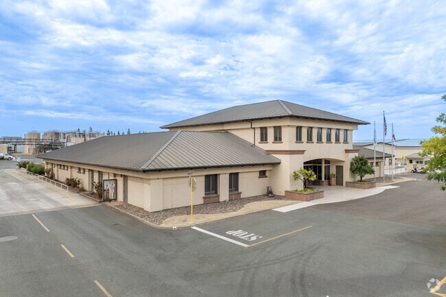

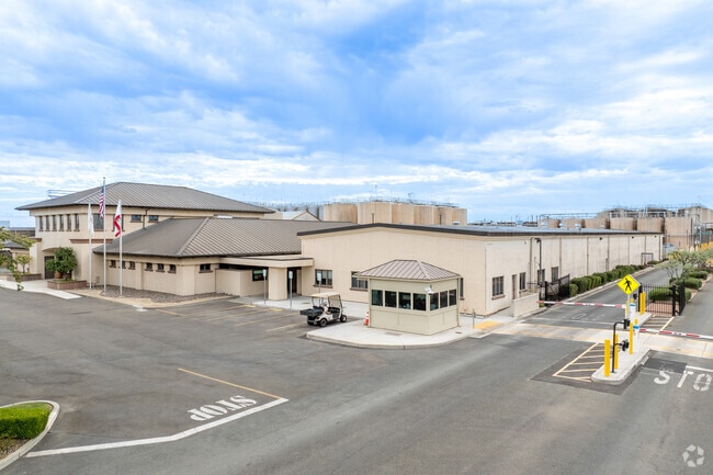
Property Detail
5950 E Woodbridge Rd
017-090-58
98-FM 53/54/55 PER 98001039/PLANNING DEPT
Winery
San Joaquin
AG40
California
AE The base floodplain where base flood elevations are provided. AE Zones are now used on new format FIRMs instead of A1-A30 Zones.
101.66 AC
2025
Lodi
2025
Stockton/Modesto
004600
Stockton-Lodi, CA
4,800 SF
NEARBY LISTINGS FOR SALE OR LEASE
DEMOGRAPHICS near 5950 E Woodbridge Rd
1 mile
3 mile
5 mile
2025 Total Population
1,026
31,978
82,496
2030 Population
1,037
33,018
85,553
Pop Growth 2025-2030
+ 1.07%
+ 3.25%
+ 3.71%
Average Age
43
38
40
2025 Total Households
377
11,162
29,680
HH Growth 2025-2030
+ 1.06%
+ 3.36%
+ 3.82%
Median Household Inc
$60,882
$72,914
$89,342
Avg Household Size
2.70
2.80
2.70
2025 Avg HH Vehicles
2.00
2.00
2.00
Median Home Value
$974,683
$459,335
$542,325
Median Year Built
1976
1962
1977
Nearby Places
Map Layers
Map Styles
 Street
 Aerial
Layers
 Traffic
 Biking
Places
Listings with unknown addresses are not visible on the map
- Restaurants
- Banks
- Shops
- Fitness
- Groceries
PUBLIC TRANSPORTATION
COMMUTER RAIL
Lodi Amtrak Station (San Joaquins - Amtrak)
Drive
Walk
Distance
Lodi Amtrak Station (San Joaquins - Amtrak)
9 min
3.9 mi
AIRPORT
Stockton Metro
Drive
Walk
Distance
Stockton Metro
32 min
22.2 mi
Freight Ports
Port of Stockton
Drive
Walk
Distance
Port of Stockton
30 min
20.7 mi
Nearby Properties
Address
Land Use
TOTAL SIZE
Lot Size
Zoning
Address
Land Use
TOTAL SIZE
Lot Size
Zoning
172,680 SF
7 AC
M
Address
Land Use
TOTAL SIZE
Lot Size
Zoning
580,500 SF
43.38 AC
Address
Land Use
TOTAL SIZE
Lot Size
Zoning
400,340 SF
20.94 AC
Address
Land Use
TOTAL SIZE
Lot Size
Zoning
1,044,011 SF
20.24 AC
Address
Land Use
TOTAL SIZE
Lot Size
Zoning
3,706 SF
10.81 AC
Address
Land Use
TOTAL SIZE
Lot Size
Zoning
10,100 SF
9.98 AC
IL
Address
Land Use
TOTAL SIZE
Lot Size
Zoning
11,520 SF
16.82 AC
AG40
Address
Land Use
TOTAL SIZE
Lot Size
Zoning
180,180 SF
16.23 AC
Address
Land Use
TOTAL SIZE
Lot Size
Zoning
473,000 SF
17.85 AC
Address
Land Use
TOTAL SIZE
Lot Size
Zoning
400,000 SF
17.81 AC
Address
Land Use
TOTAL SIZE
Lot Size
Zoning
334,515 SF
27.13 AC
Address
Land Use
TOTAL SIZE
Lot Size
Zoning
324,800 SF
17.15 AC
Address
Land Use
TOTAL SIZE
Lot Size
Zoning
5,000 SF
6.69 AC
Address
Land Use
TOTAL SIZE
Lot Size
Zoning
12,167 SF
16.71 AC
IL
Address
Land Use
TOTAL SIZE
Lot Size
Zoning
59,674 SF
2 AC
Address
Land Use
TOTAL SIZE
Lot Size
Zoning
55,632 SF
4.69 AC
Address
Land Use
TOTAL SIZE
Lot Size
Zoning
22,239 SF
1.32 AC
M
Address
Land Use
TOTAL SIZE
Lot Size
Zoning
21.73 AC
Address
Land Use
TOTAL SIZE
Lot Size
Zoning
261,100 SF
9.54 AC
Address
Land Use
TOTAL SIZE
Lot Size
Zoning
76,532 SF
3 AC
Address
Land Use
TOTAL SIZE
Lot Size
Zoning
1.50 AC
Address
Land Use
TOTAL SIZE
Lot Size
Zoning
53,167 SF
2.05 AC
Address
Land Use
TOTAL SIZE
Lot Size
Zoning
41,946 SF
3.73 AC
Address
Land Use
TOTAL SIZE
Lot Size
Zoning
6,000 SF
11.69 AC
M
Address
Land Use
TOTAL SIZE
Lot Size
Zoning
21.24 AC
Address
Land Use
TOTAL SIZE
Lot Size
Zoning
53,980 SF
1.94 AC
Address
Land Use
TOTAL SIZE
Lot Size
Zoning
41,480 SF
5.71 AC
Address
Land Use
TOTAL SIZE
Lot Size
Zoning
78.99 AC
AG40
Address
Land Use
TOTAL SIZE
Lot Size
Zoning
138,000 SF
19.03 AC
The World's #1 Commercial Real Estate Marketplace
Connect with us
© 2026 CoStar Group
The information above has been obtained from sources believed reliable. While we do not doubt its accuracy we have not verified it and make no guarantee, warranty or representation about it. It is your responsibility to independently confirm its accuracy and completeness. Any projections, opinions, assumptions, or estimates used are for example only and do not represent the current or future performance of the property. The value of this transaction to you depends on tax and other factors which should be evaluated by your tax, financial, and legal advisors. You and your advisors should conduct a careful, independent investigation of the property to determine to your satisfaction the suitability of the property for your needs.