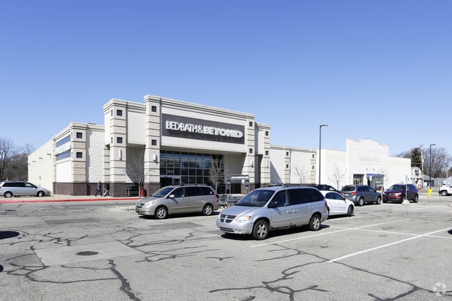
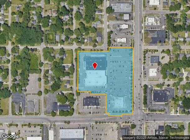
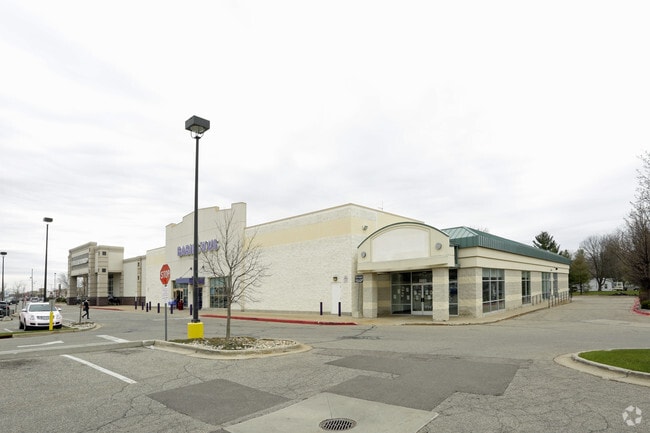
Property Record
5942 S Westnedge Ave, Portage, MI 49002
NEARBY LISTINGS FOR SALE OR LEASE
Property Detail
5942 S Westnedge Ave
Kalamazoo-Portage, MI
Westnedge Heights
10-09050-001-A
LOTS 7 THRU 14, EXC E 27 FT; & LOTS 27 THRU 48, WESTNEDGE HTS PLAT BLK A; ALSO LOTS 15 THRU 45, BLK B. ALSO, LOTS 1 THRU 6 &
Commercialnec
Kalamazoo
X
Michigan
26077C0302E
1-48
2024
5.63 AC
2025
Southern Kalamazoo County
001905
West Michigan
25,000 SF
DEMOGRAPHICS near 5942 S Westnedge Ave
1 Mile
3 Mile
5 Mile
2024 Total Population
6,906
56,608
139,170
2029 Population
6,844
56,236
139,176
Pop Growth 2024-2029
(0.90%)
(0.66%)
0.00%
Average Age
38
39
36
2024 Total Households
3,266
24,424
57,793
HH Growth 2024-2029
(0.95%)
(0.72%)
+ 0.01%
Median Household Inc
$53,773
$65,254
$55,950
Avg Household Size
2.10
2.20
2.20
2024 Avg HH Vehicles
2.00
2.00
2.00
Median Home Value
$170,302
$184,046
$195,040
Median Year Built
1972
1967
1971
Nearby Places
- Restaurants
- Banks
- Shops
- Fitness
- Groceries
PUBLIC TRANSPORTATION
COMMUTER RAIL
DRIVE
WALK
Distance
10 min
4.7 mi
AIRPORT
Kalamazoo/Battle Creek International
DRIVE
WALK
Distance
Kalamazoo/Battle Creek International
11 min
3.6 mi
SALE & LEASE HISTORY
LISTING DATE
SALE/LEASE

Sep 24, 2016
For Lease
Jun 28, 2018
For Lease
Nearby Properties
Address
Land Use
TOTAL SIZE
Lot Size
Zoning
Address
Land Use
TOTAL SIZE
Lot Size
Zoning
435.98 AC
I-2
Address
Land Use
TOTAL SIZE
Lot Size
Zoning
Address
Land Use
TOTAL SIZE
Lot Size
Zoning
Address
Land Use
TOTAL SIZE
Lot Size
Zoning
82,520 SF
39.35 AC
I-1
Address
Land Use
TOTAL SIZE
Lot Size
Zoning
35,119 SF
50.85 AC
RM-1
Address
Land Use
TOTAL SIZE
Lot Size
Zoning
Address
Land Use
TOTAL SIZE
Lot Size
Zoning
Address
Land Use
TOTAL SIZE
Lot Size
Zoning
37.40 AC
I-2
Address
Land Use
TOTAL SIZE
Lot Size
Zoning
19.39 AC
OTR
Address
Land Use
TOTAL SIZE
Lot Size
Zoning
383,638 SF
25.85 AC
B-2
Address
Land Use
TOTAL SIZE
Lot Size
Zoning
37.40 AC
I-2
Address
Land Use
TOTAL SIZE
Lot Size
Zoning
17.31 AC
PD
Address
Land Use
TOTAL SIZE
Lot Size
Zoning
16.71 AC
B-2
Address
Land Use
TOTAL SIZE
Lot Size
Zoning
255,452 SF
20.57 AC
Address
Land Use
TOTAL SIZE
Lot Size
Zoning
5.04 AC
CPD
Address
Land Use
TOTAL SIZE
Lot Size
Zoning
134,876 SF
16.45 AC
RM-15
Address
Land Use
TOTAL SIZE
Lot Size
Zoning
35.87 AC
I-1
Address
Land Use
TOTAL SIZE
Lot Size
Zoning
5,173 SF
15.81 AC
RM-1
Address
Land Use
TOTAL SIZE
Lot Size
Zoning
61,533 SF
8.42 AC
B-2
Address
Land Use
TOTAL SIZE
Lot Size
Zoning
498,424 SF
41.72 AC
M-2
Address
Land Use
TOTAL SIZE
Lot Size
Zoning
18.57 AC
Address
Land Use
TOTAL SIZE
Lot Size
Zoning
228,368 SF
9.60 AC
PUD
Address
Land Use
TOTAL SIZE
Lot Size
Zoning
606,439 SF
34.61 AC
M-2
Address
Land Use
TOTAL SIZE
Lot Size
Zoning
23,463 SF
15 AC
PD
Address
Land Use
TOTAL SIZE
Lot Size
Zoning
202,798 SF
17.67 AC
I-1
Address
Land Use
TOTAL SIZE
Lot Size
Zoning
12,480 SF
14.82 AC
RM-1
Address
Land Use
TOTAL SIZE
Lot Size
Zoning
6,874 SF
163.50 AC
PD
Address
Land Use
TOTAL SIZE
Lot Size
Zoning
Address
Land Use
TOTAL SIZE
Lot Size
Zoning
2.31 AC
CPD
Address
Land Use
TOTAL SIZE
Lot Size
Zoning
28.49 AC
I-2
The World's #1 Commercial Real Estate Marketplace
Connect with us
© 2025 CoStar Group
The information above has been obtained from sources believed reliable. While we do not doubt its accuracy we have not verified it and make no guarantee, warranty or representation about it. It is your responsibility to independently confirm its accuracy and completeness. Any projections, opinions, assumptions, or estimates used are for example only and do not represent the current or future performance of the property. The value of this transaction to you depends on tax and other factors which should be evaluated by your tax, financial, and legal advisors. You and your advisors should conduct a careful, independent investigation of the property to determine to your satisfaction the suitability of the property for your needs.