Property Record
5951 Encina Rd, Goleta, CA 93117
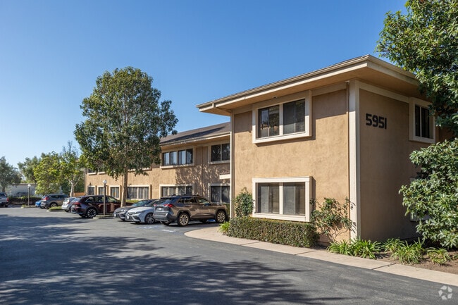

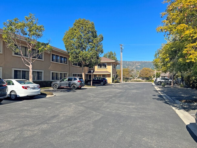

Property Detail
5951 Encina Rd
Santa Maria-Santa Barbara, CA
PARCEL MAPS 11 PG 9
069-110-080
Santa Barbara
Officebuilding
California
B and X Area of moderate flood hazard, usually the area between the limits of the 100-year and 500-year floods.
a
2024
1.14 AC
2025
Santa Barbara Airport
002914
Santa Barbara/Sta Maria/Goleta
17,440 SF
NEARBY LISTINGS FOR SALE OR LEASE
DEMOGRAPHICS near 5951 Encina Rd
1 mile
3 mile
5 mile
2025 Total Population
15,513
58,335
91,957
2030 Population
15,753
58,256
91,886
Pop Growth 2025-2030
+ 1.55%
(0.14%)
(0.08%)
Average Age
43
37
39
2025 Total Households
5,816
19,693
32,520
HH Growth 2025-2030
+ 1.87%
+ 0.02%
+ 0.01%
Median Household Inc
$108,842
$95,742
$103,165
Avg Household Size
2.50
2.60
2.60
2025 Avg HH Vehicles
2.00
2.00
2.00
Median Home Value
$1,071,268
$1,091,126
$1,077,043
Median Year Built
1970
1973
1973
Nearby Places
Map Layers
Map Styles
 Street
 Aerial
Layers
 Traffic
 Biking
Places
Listings with unknown addresses are not visible on the map
- Restaurants
- Banks
- Shops
- Fitness
- Groceries
PUBLIC TRANSPORTATION
COMMUTER RAIL
Drive
Walk
Distance
5 min
1.8 mi
Drive
Walk
Distance
13 min
9.3 mi
AIRPORT
Santa Barbara Municipal
Drive
Walk
Distance
Santa Barbara Municipal
19 min
4.0 mi
Freight Ports
The Port of Hueneme
Drive
Walk
Distance
The Port of Hueneme
65 min
48.6 mi
SALE & LEASE HISTORY
LISTING DATE
SALE/LEASE

Sep 08, 2021
For Lease
Jun 02, 2021
For Lease
Feb 17, 2023
For Lease
Dec 07, 2017
For Lease
Aug 26, 2020
For Sale
Nearby Properties
Address
Land Use
TOTAL SIZE
Lot Size
Zoning
Address
Land Use
TOTAL SIZE
Lot Size
Zoning
13,528 SF
9.35 AC
Address
Land Use
TOTAL SIZE
Lot Size
Zoning
20.78 AC
8R1
Address
Land Use
TOTAL SIZE
Lot Size
Zoning
2.50 AC
SRH20
Address
Land Use
TOTAL SIZE
Lot Size
Zoning
5.30 AC
Address
Land Use
TOTAL SIZE
Lot Size
Zoning
1.90 AC
Address
Land Use
TOTAL SIZE
Lot Size
Zoning
13.08 AC
Address
Land Use
TOTAL SIZE
Lot Size
Zoning
8.82 AC
Address
Land Use
TOTAL SIZE
Lot Size
Zoning
4.25 AC
Address
Land Use
TOTAL SIZE
Lot Size
Zoning
Address
Land Use
TOTAL SIZE
Lot Size
Zoning
2.42 AC
SRH20
Address
Land Use
TOTAL SIZE
Lot Size
Zoning
2.18 AC
Address
Land Use
TOTAL SIZE
Lot Size
Zoning
102,570 SF
14.03 AC
Address
Land Use
TOTAL SIZE
Lot Size
Zoning
3.05 AC
Address
Land Use
TOTAL SIZE
Lot Size
Zoning
37,584 SF
2 AC
SRH20
Address
Land Use
TOTAL SIZE
Lot Size
Zoning
3.81 AC
Address
Land Use
TOTAL SIZE
Lot Size
Zoning
85,052 SF
2.97 AC
SRH20
Address
Land Use
TOTAL SIZE
Lot Size
Zoning
7.18 AC
Address
Land Use
TOTAL SIZE
Lot Size
Zoning
7.99 AC
Address
Land Use
TOTAL SIZE
Lot Size
Zoning
0.87 AC
SRH20
Address
Land Use
TOTAL SIZE
Lot Size
Zoning
109,624 SF
9.11 AC
SC
Address
Land Use
TOTAL SIZE
Lot Size
Zoning
13.74 AC
Address
Land Use
TOTAL SIZE
Lot Size
Zoning
34,688 SF
2.17 AC
Address
Land Use
TOTAL SIZE
Lot Size
Zoning
6.90 AC
Address
Land Use
TOTAL SIZE
Lot Size
Zoning
0.38 AC
C2
Address
Land Use
TOTAL SIZE
Lot Size
Zoning
5.38 AC
Address
Land Use
TOTAL SIZE
Lot Size
Zoning
1.82 AC
Address
Land Use
TOTAL SIZE
Lot Size
Zoning
10.19 AC
Address
Land Use
TOTAL SIZE
Lot Size
Zoning
5.34 AC
Address
Land Use
TOTAL SIZE
Lot Size
Zoning
68,163 SF
4.04 AC
Address
Land Use
TOTAL SIZE
Lot Size
Zoning
18.65 AC
The World's #1 Commercial Real Estate Marketplace
Connect with us
© 2026 CoStar Group
The information above has been obtained from sources believed reliable. While we do not doubt its accuracy we have not verified it and make no guarantee, warranty or representation about it. It is your responsibility to independently confirm its accuracy and completeness. Any projections, opinions, assumptions, or estimates used are for example only and do not represent the current or future performance of the property. The value of this transaction to you depends on tax and other factors which should be evaluated by your tax, financial, and legal advisors. You and your advisors should conduct a careful, independent investigation of the property to determine to your satisfaction the suitability of the property for your needs.