Property Record
5953 Elementary Way, Ooltewah, TN 37363
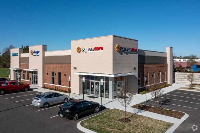

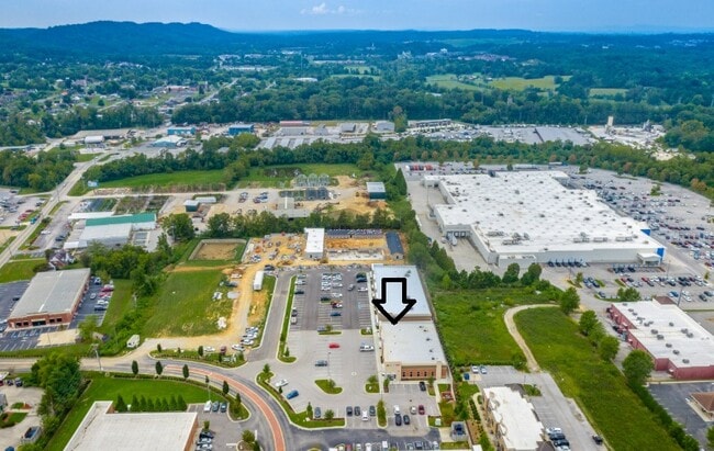
Property Detail
5953 Elementary Way
132H-B-002.03
LT 1 NOON SUB PB 118 PG 12 REV 119-90 OUT OF 132H B 002 FOR 2020
Medicalbuilding
HAMILTON
A
Tennessee
B and X Area of moderate flood hazard, usually the area between the limits of the 100-year and 500-year floods.
1
2025
0.80 AC
2025
Outlying Hamilton County
011206
Chattanooga
8,208 SF
Chattanooga, TN-GA
NEARBY LISTINGS FOR SALE OR LEASE
-
-
View all Ooltewah listings for lease on LoopNet.com
DEMOGRAPHICS near 5953 Elementary Way
1 mile
3 mile
5 mile
2025 Total Population
2,355
22,789
56,862
2030 Population
2,504
24,017
59,681
Pop Growth 2025-2030
+ 6.33%
+ 5.39%
+ 4.96%
Average Age
42
41
41
2025 Total Households
949
8,666
20,352
HH Growth 2025-2030
+ 6.53%
+ 5.62%
+ 5.19%
Median Household Inc
$88,425
$91,016
$93,344
Avg Household Size
2.40
2.50
2.60
2025 Avg HH Vehicles
2.00
2.00
2.00
Median Home Value
$401,626
$367,084
$364,455
Median Year Built
2010
2002
1998
Nearby Places
Map Layers
Map Styles
 Street
 Aerial
Layers
 Traffic
 Biking
Places
Listings with unknown addresses are not visible on the map
- Restaurants
- Banks
- Shops
- Fitness
- Groceries
PUBLIC TRANSPORTATION
AIRPORT
Lovell Field
Drive
Walk
Distance
Lovell Field
20 min
11.6 mi
Freight Ports
Georgia Ports - Savannah
Drive
Walk
Distance
Georgia Ports - Savannah
413 min
361.2 mi
SALE & LEASE HISTORY
LISTING DATE
SALE/LEASE

Sep 20, 2023
For Lease
Jul 28, 2025
For Lease
Nearby Properties
Address
Land Use
TOTAL SIZE
Lot Size
Zoning
Address
Land Use
TOTAL SIZE
Lot Size
Zoning
1,537,070 SF
354.01 AC
Address
Land Use
TOTAL SIZE
Lot Size
Zoning
25,512 SF
21.82 AC
A
Address
Land Use
TOTAL SIZE
Lot Size
Zoning
30,008 SF
20.51 AC
Address
Land Use
TOTAL SIZE
Lot Size
Zoning
1,360 SF
20.13 AC
R4
Address
Land Use
TOTAL SIZE
Lot Size
Zoning
287,820 SF
13.33 AC
R3
Address
Land Use
TOTAL SIZE
Lot Size
Zoning
100,606 SF
Address
Land Use
TOTAL SIZE
Lot Size
Zoning
24,744 SF
16.45 AC
Address
Land Use
TOTAL SIZE
Lot Size
Zoning
21,912 SF
14 AC
A
Address
Land Use
TOTAL SIZE
Lot Size
Zoning
218,244 SF
16.33 AC
Address
Land Use
TOTAL SIZE
Lot Size
Zoning
237,764 SF
60.56 AC
Address
Land Use
TOTAL SIZE
Lot Size
Zoning
60,561 SF
M2
Address
Land Use
TOTAL SIZE
Lot Size
Zoning
59,594 SF
7.61 AC
A
Address
Land Use
TOTAL SIZE
Lot Size
Zoning
181,036 SF
6.27 AC
R3
Address
Land Use
TOTAL SIZE
Lot Size
Zoning
354,853 SF
27.97 AC
M1
Address
Land Use
TOTAL SIZE
Lot Size
Zoning
636,986 SF
19.90 AC
M2
Address
Land Use
TOTAL SIZE
Lot Size
Zoning
79,101 SF
8.53 AC
C2
Address
Land Use
TOTAL SIZE
Lot Size
Zoning
54,464 SF
2.20 AC
Address
Land Use
TOTAL SIZE
Lot Size
Zoning
208,550 SF
27.21 AC
C2
Address
Land Use
TOTAL SIZE
Lot Size
Zoning
81,723 SF
12.27 AC
C2
Address
Land Use
TOTAL SIZE
Lot Size
Zoning
97,487 SF
3.65 AC
C2
Address
Land Use
TOTAL SIZE
Lot Size
Zoning
89,217 SF
11.85 AC
Address
Land Use
TOTAL SIZE
Lot Size
Zoning
62,297 SF
426 AC
IN
Address
Land Use
TOTAL SIZE
Lot Size
Zoning
1,344 SF
62.98 AC
Address
Land Use
TOTAL SIZE
Lot Size
Zoning
87,194 SF
4.37 AC
Address
Land Use
TOTAL SIZE
Lot Size
Zoning
48,720 SF
14.12 AC
Address
Land Use
TOTAL SIZE
Lot Size
Zoning
24,528 SF
1 AC
Address
Land Use
TOTAL SIZE
Lot Size
Zoning
17,522 SF
2.68 AC
Address
Land Use
TOTAL SIZE
Lot Size
Zoning
64,512 SF
9.98 AC
Address
Land Use
TOTAL SIZE
Lot Size
Zoning
199,660 SF
16.85 AC
M1
Address
Land Use
TOTAL SIZE
Lot Size
Zoning
89,748 SF
4.87 AC
The World's #1 Commercial Real Estate Marketplace
Connect with us
© 2026 CoStar Group
The information above has been obtained from sources believed reliable. While we do not doubt its accuracy we have not verified it and make no guarantee, warranty or representation about it. It is your responsibility to independently confirm its accuracy and completeness. Any projections, opinions, assumptions, or estimates used are for example only and do not represent the current or future performance of the property. The value of this transaction to you depends on tax and other factors which should be evaluated by your tax, financial, and legal advisors. You and your advisors should conduct a careful, independent investigation of the property to determine to your satisfaction the suitability of the property for your needs.