Property Record
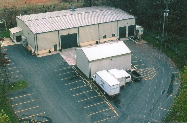
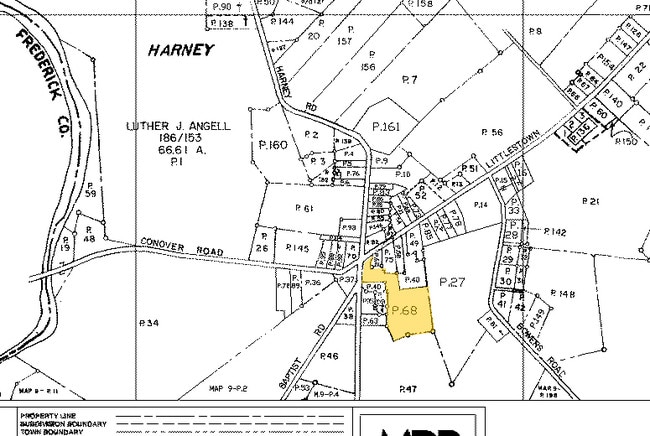
5955 Conover Rd, Taneytown, MD 21787
Property Detail
5955 Conover Rd
01-006150
LT -39511 SQ FT 5955 CONOVER ROAD W/S HARNEY ROAD
Warehouse
Carroll
I-1
Maryland
B and X Area of moderate flood hazard, usually the area between the limits of the 100-year and 500-year floods.
2.97 AC
2025
Carroll County
2025
Baltimore
501002
Baltimore-Columbia-Towson, MD
9,600 SF
NEARBY LISTINGS FOR SALE OR LEASE
-
-
View all Taneytown listings for sale on LoopNet.com
DEMOGRAPHICS near 5955 Conover Rd
1 mile
3 mile
5 mile
2025 Total Population
355
2,438
12,581
2030 Population
365
2,514
12,954
Pop Growth 2025-2030
+ 2.82%
+ 3.12%
+ 2.96%
Average Age
44
48
43
2025 Total Households
148
1,038
4,862
HH Growth 2025-2030
+ 2.70%
+ 3.47%
+ 3.06%
Median Household Inc
$82,031
$94,074
$87,827
Avg Household Size
2.40
2.30
2.60
2025 Avg HH Vehicles
2.00
2.00
2.00
Median Home Value
$389,999
$468,702
$359,185
Median Year Built
1976
1978
1981
Nearby Places
Map Layers
Map Styles
 Street
 Aerial
Layers
 Traffic
 Biking
Places
Listings with unknown addresses are not visible on the map
- Restaurants
- Banks
- Shops
- Fitness
- Groceries
PUBLIC TRANSPORTATION
AIRPORT
Hagerstown Regional/Richard A Henson Field
Drive
Walk
Distance
Hagerstown Regional/Richard A Henson Field
60 min
33.7 mi
Freight Ports
Port of Baltimore
Drive
Walk
Distance
Port of Baltimore
81 min
53.3 mi
Nearby Properties
Address
Land Use
TOTAL SIZE
Lot Size
Zoning
Address
Land Use
TOTAL SIZE
Lot Size
Zoning
6,800 SF
7.81 AC
AGRIC
Address
Land Use
TOTAL SIZE
Lot Size
Zoning
124.05 AC
RR
Address
Land Use
TOTAL SIZE
Lot Size
Zoning
116.41 AC
RR
Address
Land Use
TOTAL SIZE
Lot Size
Zoning
2,852 SF
15 AC
AGRIC
Address
Land Use
TOTAL SIZE
Lot Size
Zoning
4,800 SF
14.44 AC
AGRIC
Address
Land Use
TOTAL SIZE
Lot Size
Zoning
21.70 AC
RR
Address
Land Use
TOTAL SIZE
Lot Size
Zoning
2.05 AC
AC
Address
Land Use
TOTAL SIZE
Lot Size
Zoning
2,716 SF
2 AC
AGRIC
Address
Land Use
TOTAL SIZE
Lot Size
Zoning
15.10 AC
Address
Land Use
TOTAL SIZE
Lot Size
Zoning
4,896 SF
3.06 AC
AGRIC
Address
Land Use
TOTAL SIZE
Lot Size
Zoning
2,988 SF
5.36 AC
A
Address
Land Use
TOTAL SIZE
Lot Size
Zoning
Address
Land Use
TOTAL SIZE
Lot Size
Zoning
2,470 SF
0.75 AC
AGRIC
Address
Land Use
TOTAL SIZE
Lot Size
Zoning
2,712 SF
20 AC
AGRIC
Address
Land Use
TOTAL SIZE
Lot Size
Zoning
2,288 SF
10.19 AC
AGRIC
Address
Land Use
TOTAL SIZE
Lot Size
Zoning
2,918 SF
0.50 AC
AGRIC
Address
Land Use
TOTAL SIZE
Lot Size
Zoning
0.81 AC
Address
Land Use
TOTAL SIZE
Lot Size
Zoning
3,300 SF
4.29 AC
A
Address
Land Use
TOTAL SIZE
Lot Size
Zoning
2,587 SF
1.16 AC
AGRIC
Address
Land Use
TOTAL SIZE
Lot Size
Zoning
8.69 AC
AR
Address
Land Use
TOTAL SIZE
Lot Size
Zoning
1,002 SF
23.46 AC
AGRIC
Address
Land Use
TOTAL SIZE
Lot Size
Zoning
1,468 SF
2.21 AC
A
Address
Land Use
TOTAL SIZE
Lot Size
Zoning
1.80 AC
AC
Address
Land Use
TOTAL SIZE
Lot Size
Zoning
Address
Land Use
TOTAL SIZE
Lot Size
Zoning
1,138 SF
8.45 AC
AGRIC
Address
Land Use
TOTAL SIZE
Lot Size
Zoning
1,745 SF
1.69 AC
RR
Address
Land Use
TOTAL SIZE
Lot Size
Zoning
2,798 SF
5.29 AC
RR
Address
Land Use
TOTAL SIZE
Lot Size
Zoning
1,704 SF
11.98 AC
RR
Address
Land Use
TOTAL SIZE
Lot Size
Zoning
1,720 SF
0.61 AC
AGRIC
The World's #1 Commercial Real Estate Marketplace
Connect with us
© 2026 CoStar Group
The information above has been obtained from sources believed reliable. While we do not doubt its accuracy we have not verified it and make no guarantee, warranty or representation about it. It is your responsibility to independently confirm its accuracy and completeness. Any projections, opinions, assumptions, or estimates used are for example only and do not represent the current or future performance of the property. The value of this transaction to you depends on tax and other factors which should be evaluated by your tax, financial, and legal advisors. You and your advisors should conduct a careful, independent investigation of the property to determine to your satisfaction the suitability of the property for your needs.