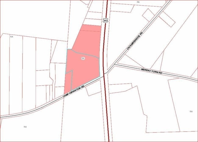
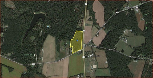
Property Record
117 Us Hwy, Willard, NC 28478
This Property Is For Sale
NEARBY LISTINGS FOR SALE OR LEASE
-
-
View all Willard listings for sale on LoopNet.com
Property Detail
117 Us Hwy
3322-45-8223-0000
1.00 AC W/S HWY 117
Vacantlandnec
Pender
X
North Carolina
3720332200J
1.04 AC
2024
East Pender County
2024
Wilmington
920300
Wilmington, NC
DEMOGRAPHICS near 117 Us Hwy
1 Mile
3 Mile
5 Mile
2024 Total Population
311
1,431
3,190
2029 Population
379
1,742
3,891
Pop Growth 2024-2029
+ 21.86%
+ 21.73%
+ 21.97%
Average Age
43
43
44
2024 Total Households
126
577
1,256
HH Growth 2024-2029
+ 22.22%
+ 22.01%
+ 22.37%
Median Household Inc
$54,375
$51,805
$50,694
Avg Household Size
2.40
2.40
2.40
2024 Avg HH Vehicles
2.00
2.00
2.00
Median Home Value
$158,571
$156,790
$150,546
Median Year Built
1992
1991
1990
Nearby Places
Map Layers
Map Styles
 Street
 Aerial
- Restaurants
- Banks
- Shops
- Fitness
- Groceries
PUBLIC TRANSPORTATION
AIRPORT
Wilmington International
DRIVE
WALK
Distance
Wilmington International
44 min
27.5 mi
Albert J Ellis
DRIVE
WALK
Distance
Albert J Ellis
49 min
32.8 mi
Freight Ports
Port of Wilmington
DRIVE
WALK
Distance
Port of Wilmington
51 min
38.7 mi
Nearby Properties
Address
Land Use
TOTAL SIZE
Lot Size
Zoning
Address
Land Use
TOTAL SIZE
Lot Size
Zoning
1,978 SF
0.96 AC
RA
Address
Land Use
TOTAL SIZE
Lot Size
Zoning
533.76 AC
Address
Land Use
TOTAL SIZE
Lot Size
Zoning
3,680 SF
162.81 AC
SEEMAP
Address
Land Use
TOTAL SIZE
Lot Size
Zoning
5,843 SF
1.92 AC
RA
Address
Land Use
TOTAL SIZE
Lot Size
Zoning
7,782 SF
3.54 AC
RA
Address
Land Use
TOTAL SIZE
Lot Size
Zoning
4,800 SF
2.35 AC
RA
Address
Land Use
TOTAL SIZE
Lot Size
Zoning
451.69 AC
SEEMAP
Address
Land Use
TOTAL SIZE
Lot Size
Zoning
3,320 SF
4.57 AC
RA
Address
Land Use
TOTAL SIZE
Lot Size
Zoning
3,024 SF
23.71 AC
RA
Address
Land Use
TOTAL SIZE
Lot Size
Zoning
147.50 AC
RA
Address
Land Use
TOTAL SIZE
Lot Size
Zoning
153.28 AC
SEEMAP
Address
Land Use
TOTAL SIZE
Lot Size
Zoning
4,212 SF
3.03 AC
RA
Address
Land Use
TOTAL SIZE
Lot Size
Zoning
161.02 AC
RA
Address
Land Use
TOTAL SIZE
Lot Size
Zoning
4,408 SF
0.45 AC
RA
Address
Land Use
TOTAL SIZE
Lot Size
Zoning
156.40 AC
SEEMAP
Address
Land Use
TOTAL SIZE
Lot Size
Zoning
2,583 SF
9 AC
RA
Address
Land Use
TOTAL SIZE
Lot Size
Zoning
282.59 AC
RA
Address
Land Use
TOTAL SIZE
Lot Size
Zoning
144.73 AC
Address
Land Use
TOTAL SIZE
Lot Size
Zoning
2,392 SF
3.76 AC
RA
Address
Land Use
TOTAL SIZE
Lot Size
Zoning
2,400 SF
0.50 AC
RA
Address
Land Use
TOTAL SIZE
Lot Size
Zoning
2,740 SF
2 AC
RA
Address
Land Use
TOTAL SIZE
Lot Size
Zoning
74.72 AC
RA
Address
Land Use
TOTAL SIZE
Lot Size
Zoning
79.56 AC
RA
Address
Land Use
TOTAL SIZE
Lot Size
Zoning
2,138 SF
95.57 AC
SEEMAP
Address
Land Use
TOTAL SIZE
Lot Size
Zoning
118.52 AC
SEEMAP
Address
Land Use
TOTAL SIZE
Lot Size
Zoning
118.42 AC
RA
Address
Land Use
TOTAL SIZE
Lot Size
Zoning
117.62 AC
RA
Address
Land Use
TOTAL SIZE
Lot Size
Zoning
3,031 SF
0.50 AC
RA
Address
Land Use
TOTAL SIZE
Lot Size
Zoning
3,136 SF
1.12 AC
R20
Address
Land Use
TOTAL SIZE
Lot Size
Zoning
3,650 SF
20.98 AC
RA
The World's #1 Commercial Real Estate Marketplace
Connect with us
© 2026 CoStar Group
The information above has been obtained from sources believed reliable. While we do not doubt its accuracy we have not verified it and make no guarantee, warranty or representation about it. It is your responsibility to independently confirm its accuracy and completeness. Any projections, opinions, assumptions, or estimates used are for example only and do not represent the current or future performance of the property. The value of this transaction to you depends on tax and other factors which should be evaluated by your tax, financial, and legal advisors. You and your advisors should conduct a careful, independent investigation of the property to determine to your satisfaction the suitability of the property for your needs.