Property Record
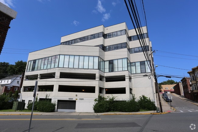
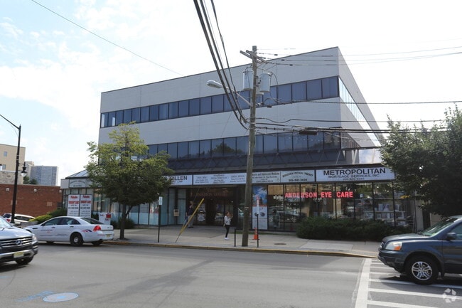
596 Anderson Ave, Cliffside Park, NJ 07010

Current Lease Availabilities
Property Detail
596 Anderson Ave
New York-Jersey City-White Plains, NY-NJ
105X246
06-01604-0000-00021
Bergen
Commercialnec
New Jersey
C1
21
B and X Area of moderate flood hazard, usually the area between the limits of the 100-year and 500-year floods.
0.59 AC
2024
GW Bridge
2025
Northern New Jersey
006201
NEARBY LISTINGS FOR SALE OR LEASE
DEMOGRAPHICS near 596 Anderson Ave
1 mile
3 mile
5 mile
2025 Total Population
52,893
708,073
2,059,781
2030 Population
54,363
737,788
2,124,565
Pop Growth 2025-2030
+ 2.78%
+ 4.20%
+ 3.15%
Average Age
42
42
41
2025 Total Households
20,851
293,829
860,787
HH Growth 2025-2030
+ 3.09%
+ 4.45%
+ 3.63%
Median Household Inc
$103,536
$78,323
$76,555
Avg Household Size
2.50
2.20
2.30
2025 Avg HH Vehicles
1.00
1.00
.00
Median Home Value
$699,289
$721,849
$807,736
Median Year Built
1969
1950
1956
Nearby Places
Map Layers
Map Styles
 Street
 Aerial
Layers
 Traffic
 Biking
Places
Listings with unknown addresses are not visible on the map
- Restaurants
- Banks
- Shops
- Fitness
- Groceries
PUBLIC TRANSPORTATION
COMMUTER RAIL
Harlem-125Th Street Station (Harlem Line - Metro-North Commuter Railroad Company (Metro-North), Hudson Line - Metro-North Commuter Railroad Company (Metro-North), New Haven Line - Metro-North Commuter Railroad Company (Metro-North))
Drive
Walk
Distance
Harlem-125Th Street Station (Harlem Line - Metro-North Commuter Railroad Company (Metro-North), Hudson Line - Metro-North Commuter Railroad Company (Metro-North), New Haven Line - Metro-North Commuter Railroad Company (Metro-North))
14 min
8.0 mi
Yankees-E 153Rd Street Station (Hudson Line - Metro-North Commuter Railroad Company (Metro-North))
Drive
Walk
Distance
Yankees-E 153Rd Street Station (Hudson Line - Metro-North Commuter Railroad Company (Metro-North))
14 min
8.1 mi
AIRPORT
LaGuardia
Drive
Walk
Distance
LaGuardia
25 min
13.7 mi
Newark Liberty International
Drive
Walk
Distance
Newark Liberty International
21 min
15.1 mi
John F Kennedy International
Drive
Walk
Distance
John F Kennedy International
36 min
24.8 mi
Freight Ports
NY - Red Hook Container Terminal
Drive
Walk
Distance
NY - Red Hook Container Terminal
30 min
15.2 mi
Nearby Properties
Address
Land Use
TOTAL SIZE
Lot Size
Zoning
Address
Land Use
TOTAL SIZE
Lot Size
Zoning
3,533,539 SF
8.37 AC
R8
Address
Land Use
TOTAL SIZE
Lot Size
Zoning
400,160 SF
10.96 AC
R7-2
Address
Land Use
TOTAL SIZE
Lot Size
Zoning
2,215,000 SF
6.43 AC
R9
Address
Land Use
TOTAL SIZE
Lot Size
Zoning
Address
Land Use
TOTAL SIZE
Lot Size
Zoning
174 AC
P2
Address
Land Use
TOTAL SIZE
Lot Size
Zoning
26.93 AC
R8
Address
Land Use
TOTAL SIZE
Lot Size
Zoning
1,368,870 SF
16.86 AC
R8
Address
Land Use
TOTAL SIZE
Lot Size
Zoning
2,278,432 SF
5.99 AC
R7-2
Address
Land Use
TOTAL SIZE
Lot Size
Zoning
555 SF
4.89 AC
H
Address
Land Use
TOTAL SIZE
Lot Size
Zoning
35.58 AC
I
Address
Land Use
TOTAL SIZE
Lot Size
Zoning
873,000 SF
9.95 AC
R7-2
Address
Land Use
TOTAL SIZE
Lot Size
Zoning
4.87 AC
R11
Address
Land Use
TOTAL SIZE
Lot Size
Zoning
1,670,868 SF
9.14 AC
R8
Address
Land Use
TOTAL SIZE
Lot Size
Zoning
0.06 AC
R8
Address
Land Use
TOTAL SIZE
Lot Size
Zoning
1,651,267 SF
1.23 AC
R8
Address
Land Use
TOTAL SIZE
Lot Size
Zoning
7.64 AC
Address
Land Use
TOTAL SIZE
Lot Size
Zoning
Address
Land Use
TOTAL SIZE
Lot Size
Zoning
45.60 AC
Address
Land Use
TOTAL SIZE
Lot Size
Zoning
2.61 AC
D5
Address
Land Use
TOTAL SIZE
Lot Size
Zoning
478,842 SF
3.56 AC
C6-1
Address
Land Use
TOTAL SIZE
Lot Size
Zoning
891,040 SF
5.63 AC
R8
Address
Land Use
TOTAL SIZE
Lot Size
Zoning
8.60 AC
P1
Address
Land Use
TOTAL SIZE
Lot Size
Zoning
0.36 AC
R8
Address
Land Use
TOTAL SIZE
Lot Size
Zoning
4.40 AC
Address
Land Use
TOTAL SIZE
Lot Size
Zoning
3.60 AC
OR1
Address
Land Use
TOTAL SIZE
Lot Size
Zoning
2,056 SF
0.06 AC
R1
Address
Land Use
TOTAL SIZE
Lot Size
Zoning
698,122 SF
3.47 AC
R8
Address
Land Use
TOTAL SIZE
Lot Size
Zoning
422,000 SF
0.86 AC
R9
Address
Land Use
TOTAL SIZE
Lot Size
Zoning
489 SF
1.24 AC
B2A
Address
Land Use
TOTAL SIZE
Lot Size
Zoning
13.09 AC
The World's #1 Commercial Real Estate Marketplace
Connect with us
© 2026 CoStar Group
The information above has been obtained from sources believed reliable. While we do not doubt its accuracy we have not verified it and make no guarantee, warranty or representation about it. It is your responsibility to independently confirm its accuracy and completeness. Any projections, opinions, assumptions, or estimates used are for example only and do not represent the current or future performance of the property. The value of this transaction to you depends on tax and other factors which should be evaluated by your tax, financial, and legal advisors. You and your advisors should conduct a careful, independent investigation of the property to determine to your satisfaction the suitability of the property for your needs.