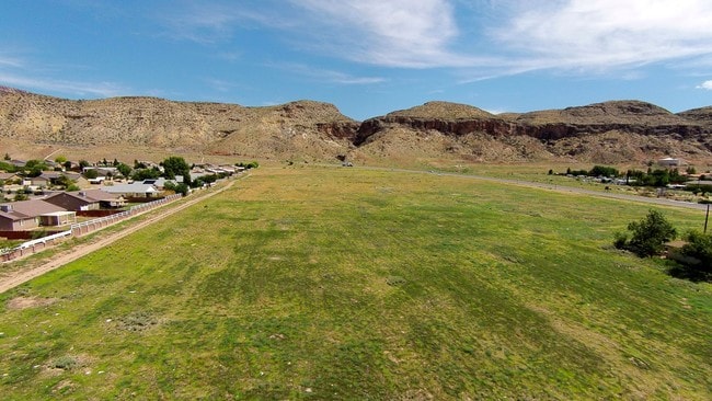
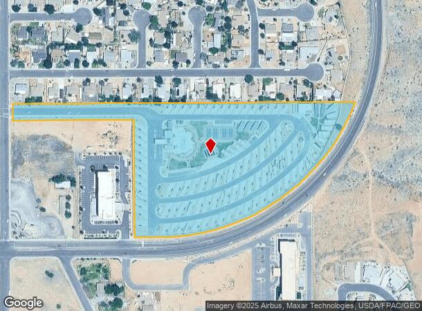
Property Record
596 N Main St, La Verkin, UT 84745
NEARBY LISTINGS FOR SALE OR LEASE
Property Detail
596 N Main St
St. George, UT
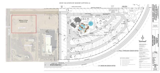
Coyote Flats
0982857
SUBDIVISION: COYOTE FLATS (LV) LOT: 2
Commercialnec
Washington
X
Utah
49053C0835G
2
2024
11.45 AC
2025
Cedar City & St George
271000
Other Market Areas
13,516 SF
DEMOGRAPHICS near 596 N Main St
1 mile
3 mile
5 mile
2024 Total Population
3,703
9,984
19,781
2029 Population
4,530
12,208
24,296
Pop Growth 2024-2029
+ 22.33%
+ 22.28%
+ 22.82%
Average Age
38
38
40
2024 Total Households
1,184
3,148
6,638
HH Growth 2024-2029
+ 22.97%
+ 22.87%
+ 23.61%
Median Household Inc
$47,599
$49,788
$55,406
Avg Household Size
3.10
3.10
2.90
2024 Avg HH Vehicles
2.00
2.00
2.00
Median Home Value
$286,062
$328,895
$367,728
Median Year Built
1994
1992
1998
Nearby Places
Map Layers
Map Styles
 Street
 Aerial
Transit
 Traffic
 Biking
Places
Listings with unknown addresses are not visible on the map
- Restaurants
- Banks
- Shops
- Fitness
- Groceries
PUBLIC TRANSPORTATION
AIRPORT
St George Regional
Drive
Walk
Distance
St George Regional
36 min
28.6 mi
Freight Ports
Port of Long Beach
Drive
Walk
Distance
Port of Long Beach
468 min
427.8 mi
SALE & LEASE HISTORY
LISTING DATE
SALE/LEASE

Nov 25, 2019
For Sale
Nearby Properties
Address
Land Use
TOTAL SIZE
Lot Size
Zoning
Address
Land Use
TOTAL SIZE
Lot Size
Zoning
93,494 SF
23.97 AC
PF
Address
Land Use
TOTAL SIZE
Lot Size
Zoning
70,194 SF
2.79 AC
Address
Land Use
TOTAL SIZE
Lot Size
Zoning
55,676 SF
8.90 AC
PF
Address
Land Use
TOTAL SIZE
Lot Size
Zoning
50,591 SF
2.27 AC
Address
Land Use
TOTAL SIZE
Lot Size
Zoning
40,650 SF
2.99 AC
Address
Land Use
TOTAL SIZE
Lot Size
Zoning
30,643 SF
26.13 AC
PDO
Address
Land Use
TOTAL SIZE
Lot Size
Zoning
33,657 SF
12.90 AC
Address
Land Use
TOTAL SIZE
Lot Size
Zoning
134,714 SF
14.80 AC
M-1
Address
Land Use
TOTAL SIZE
Lot Size
Zoning
30,519 SF
5.76 AC
HC
Address
Land Use
TOTAL SIZE
Lot Size
Zoning
22,576 SF
5.35 AC
Address
Land Use
TOTAL SIZE
Lot Size
Zoning
48,990 SF
24.69 AC
PF
Address
Land Use
TOTAL SIZE
Lot Size
Zoning
41,124 SF
4.83 AC
Address
Land Use
TOTAL SIZE
Lot Size
Zoning
25,105 SF
2.97 AC
Address
Land Use
TOTAL SIZE
Lot Size
Zoning
87,486 SF
3.06 AC
Address
Land Use
TOTAL SIZE
Lot Size
Zoning
10,491 SF
10.93 AC
Address
Land Use
TOTAL SIZE
Lot Size
Zoning
6,550 SF
60 AC
OSC20
Address
Land Use
TOTAL SIZE
Lot Size
Zoning
7,326 SF
1.39 AC
Address
Land Use
TOTAL SIZE
Lot Size
Zoning
11,994 SF
15.02 AC
Address
Land Use
TOTAL SIZE
Lot Size
Zoning
19,050 SF
2.53 AC
M-1
Address
Land Use
TOTAL SIZE
Lot Size
Zoning
16,551 SF
7.06 AC
Address
Land Use
TOTAL SIZE
Lot Size
Zoning
15,885 SF
2.51 AC
Address
Land Use
TOTAL SIZE
Lot Size
Zoning
3,940 SF
1.44 AC
HC
Address
Land Use
TOTAL SIZE
Lot Size
Zoning
4.80 AC
Address
Land Use
TOTAL SIZE
Lot Size
Zoning
20,409 SF
1.75 AC
GC
Address
Land Use
TOTAL SIZE
Lot Size
Zoning
14,660 SF
0.54 AC
PF
Address
Land Use
TOTAL SIZE
Lot Size
Zoning
6.12 AC
Address
Land Use
TOTAL SIZE
Lot Size
Zoning
18,373 SF
1.39 AC
Address
Land Use
TOTAL SIZE
Lot Size
Zoning
7,397 SF
1.66 AC
The World's #1 Commercial Real Estate Marketplace
Connect with us
© 2026 CoStar Group
The information above has been obtained from sources believed reliable. While we do not doubt its accuracy we have not verified it and make no guarantee, warranty or representation about it. It is your responsibility to independently confirm its accuracy and completeness. Any projections, opinions, assumptions, or estimates used are for example only and do not represent the current or future performance of the property. The value of this transaction to you depends on tax and other factors which should be evaluated by your tax, financial, and legal advisors. You and your advisors should conduct a careful, independent investigation of the property to determine to your satisfaction the suitability of the property for your needs.