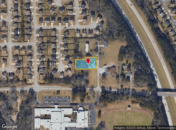
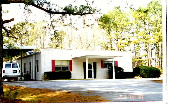
Property Record
5965 Pamela Dr, Rex, GA 30273


NEARBY LISTINGS FOR SALE OR LEASE
Property Detail
5965 Pamela Dr
12-0151D-00A-005A
Bettie J Pitts-Pitts Playland
Daycare
Clayton
X
Georgia
13063C0083F
131
2025
0.72 AC
2025
Forest Park/Morrow
040420
Atlanta
3,280 SF
Atlanta-Sandy Springs-Roswell, GA
DEMOGRAPHICS near 5965 Pamela Dr
1 Mile
3 Mile
5 Mile
2024 Total Population
7,776
61,939
143,911
2029 Population
7,680
62,144
146,421
Pop Growth 2024-2029
(1.23%)
+ 0.33%
+ 1.74%
Average Age
36
36
37
2024 Total Households
2,583
21,602
50,457
HH Growth 2024-2029
(1.20%)
+ 0.41%
+ 1.86%
Median Household Inc
$66,358
$51,870
$57,833
Avg Household Size
2.90
2.80
2.80
2024 Avg HH Vehicles
2.00
2.00
2.00
Median Home Value
$205,994
$171,527
$178,726
Median Year Built
1999
1992
1990
Nearby Places
Map Layers
Map Styles
 Street
 Aerial
- Restaurants
- Banks
- Shops
- Fitness
- Groceries
PUBLIC TRANSPORTATION
AIRPORT
Hartsfield - Jackson Atlanta International
DRIVE
WALK
Distance
Hartsfield - Jackson Atlanta International
22 min
10.7 mi
Nearby Properties
Address
Land Use
TOTAL SIZE
Lot Size
Zoning
Address
Land Use
TOTAL SIZE
Lot Size
Zoning
570,146 SF
42.33 AC
I
Address
Land Use
TOTAL SIZE
Lot Size
Zoning
42,671 SF
56.11 AC
I
Address
Land Use
TOTAL SIZE
Lot Size
Zoning
368 SF
42.85 AC
RM
Address
Land Use
TOTAL SIZE
Lot Size
Zoning
217,289 SF
52.12 AC
OI
Address
Land Use
TOTAL SIZE
Lot Size
Zoning
25.16 AC
RM
Address
Land Use
TOTAL SIZE
Lot Size
Zoning
330 SF
33.30 AC
RM
Address
Land Use
TOTAL SIZE
Lot Size
Zoning
659,547 SF
31.20 AC
HI
Address
Land Use
TOTAL SIZE
Lot Size
Zoning
284 SF
29 AC
RM
Address
Land Use
TOTAL SIZE
Lot Size
Zoning
707,780 SF
85.14 AC
MXI
Address
Land Use
TOTAL SIZE
Lot Size
Zoning
216 SF
31.17 AC
RM
Address
Land Use
TOTAL SIZE
Lot Size
Zoning
20.65 AC
RM
Address
Land Use
TOTAL SIZE
Lot Size
Zoning
161,920 SF
14.26 AC
I
Address
Land Use
TOTAL SIZE
Lot Size
Zoning
332,442 SF
28.80 AC
HI
Address
Land Use
TOTAL SIZE
Lot Size
Zoning
229,829 SF
24.15 AC
HI
Address
Land Use
TOTAL SIZE
Lot Size
Zoning
220,000 SF
54.68 AC
I
Address
Land Use
TOTAL SIZE
Lot Size
Zoning
200 SF
22 AC
RM
Address
Land Use
TOTAL SIZE
Lot Size
Zoning
87,449 SF
14 AC
MC
Address
Land Use
TOTAL SIZE
Lot Size
Zoning
142,742 SF
27.10 AC
RS110
Address
Land Use
TOTAL SIZE
Lot Size
Zoning
200 SF
25 AC
RM
Address
Land Use
TOTAL SIZE
Lot Size
Zoning
259,168 SF
29.08 AC
GB
Address
Land Use
TOTAL SIZE
Lot Size
Zoning
312,798 SF
21.38 AC
HI
Address
Land Use
TOTAL SIZE
Lot Size
Zoning
272,376 SF
17.73 AC
MXI
Address
Land Use
TOTAL SIZE
Lot Size
Zoning
182 SF
19.46 AC
RM
Address
Land Use
TOTAL SIZE
Lot Size
Zoning
120 SF
26.48 AC
RM
Address
Land Use
TOTAL SIZE
Lot Size
Zoning
240 SF
25.09 AC
RM
Address
Land Use
TOTAL SIZE
Lot Size
Zoning
399,000 SF
30.50 AC
WH
Address
Land Use
TOTAL SIZE
Lot Size
Zoning
400,000 SF
42.87 AC
HI
Address
Land Use
TOTAL SIZE
Lot Size
Zoning
232 SF
21.38 AC
C
Address
Land Use
TOTAL SIZE
Lot Size
Zoning
210,670 SF
14.80 AC
HI
Address
Land Use
TOTAL SIZE
Lot Size
Zoning
271,919 SF
17.89 AC
HI
The World's #1 Commercial Real Estate Marketplace
Connect with us
© 2025 CoStar Group
The information above has been obtained from sources believed reliable. While we do not doubt its accuracy we have not verified it and make no guarantee, warranty or representation about it. It is your responsibility to independently confirm its accuracy and completeness. Any projections, opinions, assumptions, or estimates used are for example only and do not represent the current or future performance of the property. The value of this transaction to you depends on tax and other factors which should be evaluated by your tax, financial, and legal advisors. You and your advisors should conduct a careful, independent investigation of the property to determine to your satisfaction the suitability of the property for your needs.