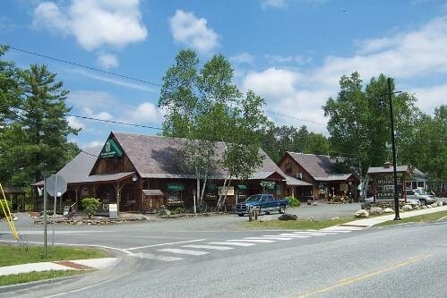
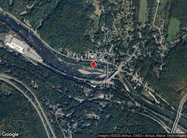
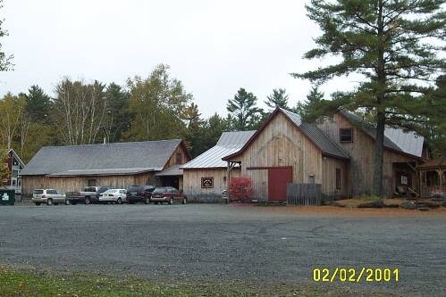
Property Record
5967 Woodstock Rd, White River Junction, VT 05001
NEARBY LISTINGS FOR SALE OR LEASE
Property Detail
5967 Woodstock Rd
Claremont-Lebanon, NH-VT
381 SALES - SMALL RETAIL
285-090-11349
Windsor
Storebuilding
Vermont
2021
1.98 AC
2021
Vermont South Area
965502
Other Market Areas
8,686 SF
DEMOGRAPHICS near 5967 Woodstock Rd
1 Mile
3 Mile
5 Mile
2024 Total Population
744
2,584
9,954
2029 Population
716
2,490
9,918
Pop Growth 2024-2029
(3.76%)
(3.64%)
(0.36%)
Average Age
44
45
44
2024 Total Households
318
1,103
4,533
HH Growth 2024-2029
(4.09%)
(3.63%)
(0.29%)
Median Household Inc
$58,043
$69,422
$68,721
Avg Household Size
2.30
2.30
2.10
2024 Avg HH Vehicles
2.00
2.00
2.00
Median Home Value
$339,091
$343,038
$286,742
Median Year Built
1978
1979
1977
Nearby Places
- Restaurants
- Banks
- Shops
- Fitness
- Groceries
PUBLIC TRANSPORTATION
COMMUTER RAIL
White River Junction Amtrak Station (Vermonter - Amtrak)
DRIVE
WALK
Distance
White River Junction Amtrak Station (Vermonter - Amtrak)
4 min
1.7 mi
Freight Ports
Albany, NY Port
DRIVE
WALK
Distance
Albany, NY Port
195 min
132.0 mi
SALE & LEASE HISTORY
LISTING DATE
SALE/LEASE

Sep 25, 2016
For Lease
Sep 23, 2016
For Sale
Mar 04, 2019
For Lease
Nearby Properties
Address
Land Use
TOTAL SIZE
Lot Size
Zoning
Address
Land Use
TOTAL SIZE
Lot Size
Zoning
447.50 AC
INDL
Address
Land Use
TOTAL SIZE
Lot Size
Zoning
29.80 AC
GC
Address
Land Use
TOTAL SIZE
Lot Size
Zoning
1,315 SF
16.35 AC
RL3
Address
Land Use
TOTAL SIZE
Lot Size
Zoning
86.78 AC
IC
Address
Land Use
TOTAL SIZE
Lot Size
Zoning
14.11 AC
INDL
Address
Land Use
TOTAL SIZE
Lot Size
Zoning
22.14 AC
GC
Address
Land Use
TOTAL SIZE
Lot Size
Zoning
Address
Land Use
TOTAL SIZE
Lot Size
Zoning
22.88 AC
GC
Address
Land Use
TOTAL SIZE
Lot Size
Zoning
Address
Land Use
TOTAL SIZE
Lot Size
Zoning
36.71 AC
GC
Address
Land Use
TOTAL SIZE
Lot Size
Zoning
20.61 AC
GC
Address
Land Use
TOTAL SIZE
Lot Size
Zoning
80,493 SF
7.39 AC
GC
Address
Land Use
TOTAL SIZE
Lot Size
Zoning
7.89 AC
GC
Address
Land Use
TOTAL SIZE
Lot Size
Zoning
Address
Land Use
TOTAL SIZE
Lot Size
Zoning
7.63 AC
GC
Address
Land Use
TOTAL SIZE
Lot Size
Zoning
54.48 AC
R3
Address
Land Use
TOTAL SIZE
Lot Size
Zoning
15.60 AC
GC
Address
Land Use
TOTAL SIZE
Lot Size
Zoning
26.10 AC
R2
Address
Land Use
TOTAL SIZE
Lot Size
Zoning
44,695 SF
35.80 AC
HC
Address
Land Use
TOTAL SIZE
Lot Size
Zoning
163,990 SF
10.19 AC
INDL
Address
Land Use
TOTAL SIZE
Lot Size
Zoning
Address
Land Use
TOTAL SIZE
Lot Size
Zoning
0.87 AC
CB
Address
Land Use
TOTAL SIZE
Lot Size
Zoning
7.28 AC
GC
Address
Land Use
TOTAL SIZE
Lot Size
Zoning
102,489 SF
GC
Address
Land Use
TOTAL SIZE
Lot Size
Zoning
4.54 AC
GC
Address
Land Use
TOTAL SIZE
Lot Size
Zoning
7.88 AC
R2
Address
Land Use
TOTAL SIZE
Lot Size
Zoning
62,991 SF
7.38 AC
INDL
Address
Land Use
TOTAL SIZE
Lot Size
Zoning
24,820 SF
2.89 AC
CB
Address
Land Use
TOTAL SIZE
Lot Size
Zoning
Address
Land Use
TOTAL SIZE
Lot Size
Zoning
32,770 SF
5.31 AC
R3
The World's #1 Commercial Real Estate Marketplace
Connect with us
© 2025 CoStar Group
The information above has been obtained from sources believed reliable. While we do not doubt its accuracy we have not verified it and make no guarantee, warranty or representation about it. It is your responsibility to independently confirm its accuracy and completeness. Any projections, opinions, assumptions, or estimates used are for example only and do not represent the current or future performance of the property. The value of this transaction to you depends on tax and other factors which should be evaluated by your tax, financial, and legal advisors. You and your advisors should conduct a careful, independent investigation of the property to determine to your satisfaction the suitability of the property for your needs.