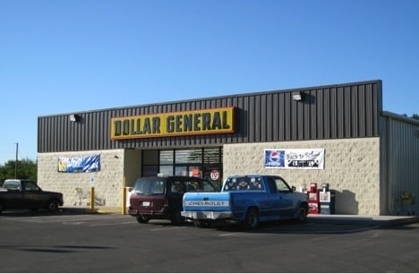
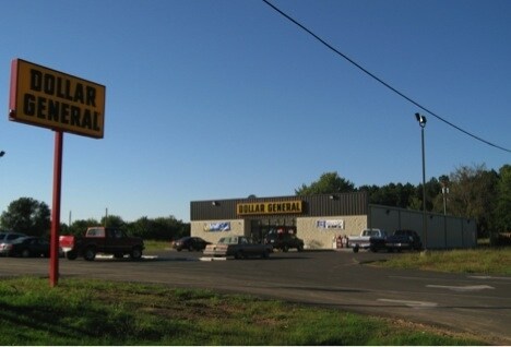
Property Record
597 Highway 270, Wister, OK 74966

NEARBY LISTINGS FOR SALE OR LEASE
-
-
View all Wister listings for sale on LoopNet.com
Property Detail
597 Highway 270
0000-24-06N-24E-0-020-00
SEC 24 TWP 6N RNG 24E PT SE SW BEG 526.48N SE COR SE SW S74DG21'W 166.08 N328.12 N89DG25'E 160 S284.96 POB DD B1865 P767
Storebuilding
Le Flore
2024
Oklahoma
2025
1.13 AC
040500
Le Flore County
1,138 SF
Fort Smith
DEMOGRAPHICS near 597 Highway 270
1 Mile
3 Mile
5 Mile
2024 Total Population
986
1,599
3,332
2029 Population
1,013
1,641
3,425
Pop Growth 2024-2029
+ 2.74%
+ 2.63%
+ 2.79%
Average Age
41
41
41
2024 Total Households
392
624
1,275
HH Growth 2024-2029
+ 2.81%
+ 2.56%
+ 2.75%
Median Household Inc
$48,749
$49,296
$48,320
Avg Household Size
2.50
2.50
2.50
2024 Avg HH Vehicles
2.00
2.00
2.00
Median Home Value
$150,000
$154,347
$152,797
Median Year Built
1985
1985
1986
Nearby Places
Map Layers
Map Styles
 Street
 Aerial
- Restaurants
- Banks
- Shops
- Fitness
- Groceries
PUBLIC TRANSPORTATION
AIRPORT
Fort Smith Regional
DRIVE
WALK
Distance
Fort Smith Regional
62 min
37.9 mi
Nearby Properties
Address
Land Use
TOTAL SIZE
Lot Size
Zoning
Address
Land Use
TOTAL SIZE
Lot Size
Zoning
358 SF
0.20 AC
C1
Address
Land Use
TOTAL SIZE
Lot Size
Zoning
700 SF
0.30 AC
C1
Address
Land Use
TOTAL SIZE
Lot Size
Zoning
5,000 SF
1.70 AC
C1
Address
Land Use
TOTAL SIZE
Lot Size
Zoning
1,568 SF
0.32 AC
R1
Address
Land Use
TOTAL SIZE
Lot Size
Zoning
2,210 SF
1.25 AC
R1
Address
Land Use
TOTAL SIZE
Lot Size
Zoning
0.60 AC
C1
Address
Land Use
TOTAL SIZE
Lot Size
Zoning
2,988 SF
0.26 AC
C1
Address
Land Use
TOTAL SIZE
Lot Size
Zoning
3.24 AC
C1
Address
Land Use
TOTAL SIZE
Lot Size
Zoning
26,880 SF
4.29 AC
C1
Address
Land Use
TOTAL SIZE
Lot Size
Zoning
4,000 SF
6.47 AC
C1
Address
Land Use
TOTAL SIZE
Lot Size
Zoning
4,000 SF
1.40 AC
Address
Land Use
TOTAL SIZE
Lot Size
Zoning
840 SF
0.72 AC
C1
Address
Land Use
TOTAL SIZE
Lot Size
Zoning
3,000 SF
0.37 AC
R1
Address
Land Use
TOTAL SIZE
Lot Size
Zoning
59.13 AC
TM
Address
Land Use
TOTAL SIZE
Lot Size
Zoning
747 SF
0.31 AC
C1
Address
Land Use
TOTAL SIZE
Lot Size
Zoning
1,140 SF
6.19 AC
R1
Address
Land Use
TOTAL SIZE
Lot Size
Zoning
1,056 SF
0.37 AC
R1
Address
Land Use
TOTAL SIZE
Lot Size
Zoning
2,320 SF
0.07 AC
C2
Address
Land Use
TOTAL SIZE
Lot Size
Zoning
3,000 SF
0.67 AC
C1
Address
Land Use
TOTAL SIZE
Lot Size
Zoning
640 SF
1.61 AC
C1
Address
Land Use
TOTAL SIZE
Lot Size
Zoning
2,199 SF
2.29 AC
R1
Address
Land Use
TOTAL SIZE
Lot Size
Zoning
1,680 SF
0.07 AC
C1
Address
Land Use
TOTAL SIZE
Lot Size
Zoning
12.19 AC
R1
Address
Land Use
TOTAL SIZE
Lot Size
Zoning
1.84 AC
R1
The World's #1 Commercial Real Estate Marketplace
Connect with us
© 2026 CoStar Group
The information above has been obtained from sources believed reliable. While we do not doubt its accuracy we have not verified it and make no guarantee, warranty or representation about it. It is your responsibility to independently confirm its accuracy and completeness. Any projections, opinions, assumptions, or estimates used are for example only and do not represent the current or future performance of the property. The value of this transaction to you depends on tax and other factors which should be evaluated by your tax, financial, and legal advisors. You and your advisors should conduct a careful, independent investigation of the property to determine to your satisfaction the suitability of the property for your needs.