Property Record
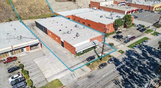
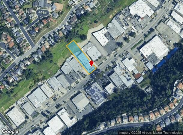
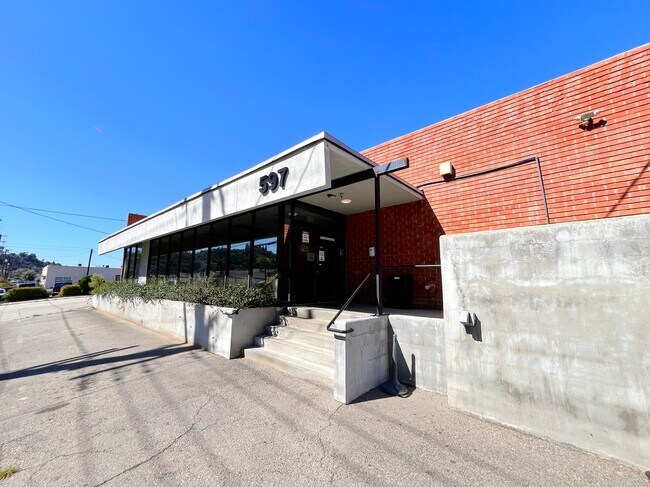
597 Monterey Pass Rd, Monterey Park, CA 91754
Current Lease Availabilities
NEARBY LISTINGS FOR SALE OR LEASE
Property Detail
597 Monterey Pass Rd
Los Angeles-Long Beach-Glendale, CA
22399
5254-019-115
TRACT # 22399 LOT 21
Foodprocessing
Los Angeles
X
California
06037C1645F
21
2024
0.90 AC
2025
Lower San Gabriel Valley
482001
Los Angeles
13,572 SF
DEMOGRAPHICS near 597 Monterey Pass Rd
1 Mile
3 Mile
5 Mile
2024 Total Population
20,142
286,042
654,664
2029 Population
19,444
274,467
629,314
Pop Growth 2024-2029
(3.47%)
(4.05%)
(3.87%)
Average Age
43
40
40
2024 Total Households
7,067
87,518
204,200
HH Growth 2024-2029
(3.74%)
(4.23%)
(4.07%)
Median Household Inc
$85,222
$66,675
$69,702
Avg Household Size
2.80
3.20
3.10
2024 Avg HH Vehicles
2.00
2.00
2.00
Median Home Value
$796,020
$720,928
$751,329
Median Year Built
1959
1955
1956
Nearby Places
- Restaurants
- Banks
- Shops
- Fitness
- Groceries
PUBLIC TRANSPORTATION
COMMUTER RAIL
Montebello/Commerce (Riverside Line - Southern California Regional Rail Authority (Metrolink))
DRIVE
WALK
Distance
Montebello/Commerce (Riverside Line - Southern California Regional Rail Authority (Metrolink))
11 min
5.3 mi
AIRPORT
Long Beach (Daugherty Field)
DRIVE
WALK
Distance
Long Beach (Daugherty Field)
30 min
19.8 mi
Bob Hope
DRIVE
WALK
Distance
Bob Hope
29 min
21.5 mi
Los Angeles International
DRIVE
WALK
Distance
Los Angeles International
34 min
21.9 mi
Freight Ports
Port of Long Beach
DRIVE
WALK
Distance
Port of Long Beach
32 min
22.6 mi
Nearby Properties
Address
Land Use
TOTAL SIZE
Lot Size
Zoning
Address
Land Use
TOTAL SIZE
Lot Size
Zoning
534,225 SF
Address
Land Use
TOTAL SIZE
Lot Size
Zoning
460,590 SF
23.95 AC
ALMPD*
Address
Land Use
TOTAL SIZE
Lot Size
Zoning
516,474 SF
4.37 AC
ALCBD/DRD*
Address
Land Use
TOTAL SIZE
Lot Size
Zoning
151,450 SF
6.59 AC
MPSP*
Address
Land Use
TOTAL SIZE
Lot Size
Zoning
220,717 SF
2.14 AC
MPSP*
Address
Land Use
TOTAL SIZE
Lot Size
Zoning
155,920 SF
12.13 AC
MPM*
Address
Land Use
TOTAL SIZE
Lot Size
Zoning
198,958 SF
7.50 AC
LCM2*
Address
Land Use
TOTAL SIZE
Lot Size
Zoning
500,495 SF
16.23 AC
CMM2*
Address
Land Use
TOTAL SIZE
Lot Size
Zoning
116,480 SF
11.81 AC
MPC2
Address
Land Use
TOTAL SIZE
Lot Size
Zoning
107,778 SF
8.87 AC
MPM*
Address
Land Use
TOTAL SIZE
Lot Size
Zoning
199,809 SF
7.57 AC
CMM2*
Address
Land Use
TOTAL SIZE
Lot Size
Zoning
621,229 SF
7.98 AC
MPM*
Address
Land Use
TOTAL SIZE
Lot Size
Zoning
174,799 SF
3.94 AC
CMM2*
Address
Land Use
TOTAL SIZE
Lot Size
Zoning
77,778 SF
2.87 AC
ALRPD*
Address
Land Use
TOTAL SIZE
Lot Size
Zoning
203,491 SF
15.84 AC
MPM*
Address
Land Use
TOTAL SIZE
Lot Size
Zoning
66,102 SF
1.90 AC
MPCM*
Address
Land Use
TOTAL SIZE
Lot Size
Zoning
85,890 SF
2.33 AC
MPR2SCH*
Address
Land Use
TOTAL SIZE
Lot Size
Zoning
86,290 SF
3.10 AC
MNR4*
Address
Land Use
TOTAL SIZE
Lot Size
Zoning
296,309 SF
5.29 AC
LAM1
Address
Land Use
TOTAL SIZE
Lot Size
Zoning
130,189 SF
6.59 AC
MPOPCD*
Address
Land Use
TOTAL SIZE
Lot Size
Zoning
146,264 SF
1.87 AC
LAMR1
Address
Land Use
TOTAL SIZE
Lot Size
Zoning
288,700 SF
6.19 AC
MPOP*
Address
Land Use
TOTAL SIZE
Lot Size
Zoning
155,339 SF
3.99 AC
LAMR1
Address
Land Use
TOTAL SIZE
Lot Size
Zoning
168,314 SF
7.35 AC
CMM2*
Address
Land Use
TOTAL SIZE
Lot Size
Zoning
203,860 SF
1.92 AC
MPSP*
Address
Land Use
TOTAL SIZE
Lot Size
Zoning
48,018 SF
2.64 AC
SLC3*
Address
Land Use
TOTAL SIZE
Lot Size
Zoning
119,883 SF
5.93 AC
MPOP*
Address
Land Use
TOTAL SIZE
Lot Size
Zoning
435,600 SF
10.57 AC
LACM
Address
Land Use
TOTAL SIZE
Lot Size
Zoning
121,733 SF
5.59 AC
ALMPD*
Address
Land Use
TOTAL SIZE
Lot Size
Zoning
41,761 SF
3.25 AC
ALCPD-R1*
The World's #1 Commercial Real Estate Marketplace
Connect with us
© 2025 CoStar Group
The information above has been obtained from sources believed reliable. While we do not doubt its accuracy we have not verified it and make no guarantee, warranty or representation about it. It is your responsibility to independently confirm its accuracy and completeness. Any projections, opinions, assumptions, or estimates used are for example only and do not represent the current or future performance of the property. The value of this transaction to you depends on tax and other factors which should be evaluated by your tax, financial, and legal advisors. You and your advisors should conduct a careful, independent investigation of the property to determine to your satisfaction the suitability of the property for your needs.