Property Record
5975 Pageland Ln, Gainesville, VA 20155
Property Detail
5975 Pageland Ln
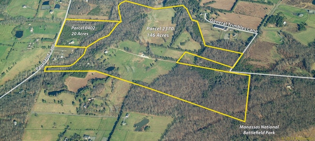
7498-96-2370
CEMETERY ON PARCEL
Multifamilydwelling
Prince William
A1
Virginia
AE The base floodplain where base flood elevations are provided. AE Zones are now used on new format FIRMs instead of A1-A30 Zones.
2370
2024
146.03 AC
2025
Route 29/I-66 Corridor
901503
Washington, DC
2,854 SF
Washington-Arlington-Alexandria, DC-VA-MD-WV
NEARBY LISTINGS FOR SALE OR LEASE
DEMOGRAPHICS near 5975 Pageland Ln
1 mile
3 mile
5 mile
2025 Total Population
417
14,463
106,670
2030 Population
436
14,869
109,692
Pop Growth 2025-2030
+ 4.56%
+ 2.81%
+ 2.83%
Average Age
43
48
38
2025 Total Households
124
5,404
34,845
HH Growth 2025-2030
+ 4.03%
+ 2.66%
+ 2.80%
Median Household Inc
$166,304
$155,114
$144,275
Avg Household Size
3.20
2.60
3.00
2025 Avg HH Vehicles
3.00
2.00
2.00
Median Home Value
$1,010,345
$729,759
$668,997
Median Year Built
1976
2004
2001
Nearby Places
Map Layers
Map Styles
 Street
 Aerial
Layers
 Traffic
 Biking
Places
Listings with unknown addresses are not visible on the map
- Restaurants
- Banks
- Shops
- Fitness
- Groceries
PUBLIC TRANSPORTATION
AIRPORT
Washington Dulles International
Drive
Walk
Distance
Washington Dulles International
37 min
23.5 mi
Ronald Reagan Washington Ntl
Drive
Walk
Distance
Ronald Reagan Washington Ntl
51 min
38.1 mi
Freight Ports
Port of Baltimore
Drive
Walk
Distance
Port of Baltimore
96 min
73.9 mi
SALE & LEASE HISTORY
LISTING DATE
SALE/LEASE

Sep 24, 2016
For Sale
Nearby Properties
Address
Land Use
TOTAL SIZE
Lot Size
Zoning
Address
Land Use
TOTAL SIZE
Lot Size
Zoning
482,223 SF
28.10 AC
PBD
Address
Land Use
TOTAL SIZE
Lot Size
Zoning
117.22 AC
M1
Address
Land Use
TOTAL SIZE
Lot Size
Zoning
115,600 SF
10.06 AC
M1
Address
Land Use
TOTAL SIZE
Lot Size
Zoning
123,534 SF
7.85 AC
M1
Address
Land Use
TOTAL SIZE
Lot Size
Zoning
127,700 SF
7.92 AC
M1
Address
Land Use
TOTAL SIZE
Lot Size
Zoning
258,716 SF
58.54 AC
M1
Address
Land Use
TOTAL SIZE
Lot Size
Zoning
58.30 AC
M1
Address
Land Use
TOTAL SIZE
Lot Size
Zoning
40.47 AC
PBD
Address
Land Use
TOTAL SIZE
Lot Size
Zoning
482,200 SF
29.18 AC
PBD
Address
Land Use
TOTAL SIZE
Lot Size
Zoning
161.28 AC
PBD
Address
Land Use
TOTAL SIZE
Lot Size
Zoning
124.18 AC
PBD
Address
Land Use
TOTAL SIZE
Lot Size
Zoning
298,474 SF
11.60 AC
PMR
Address
Land Use
TOTAL SIZE
Lot Size
Zoning
28.38 AC
PBD
Address
Land Use
TOTAL SIZE
Lot Size
Zoning
28.35 AC
PMD
Address
Land Use
TOTAL SIZE
Lot Size
Zoning
150,000 SF
9.51 AC
M1
Address
Land Use
TOTAL SIZE
Lot Size
Zoning
175,260 SF
30.39 AC
MT
Address
Land Use
TOTAL SIZE
Lot Size
Zoning
23.65 AC
R4
Address
Land Use
TOTAL SIZE
Lot Size
Zoning
9,100 SF
217.60 AC
MRHI
Address
Land Use
TOTAL SIZE
Lot Size
Zoning
363,220 SF
20.35 AC
PBD
Address
Land Use
TOTAL SIZE
Lot Size
Zoning
8,786 SF
1,337.29 AC
A1
Address
Land Use
TOTAL SIZE
Lot Size
Zoning
62.97 AC
PBD
Address
Land Use
TOTAL SIZE
Lot Size
Zoning
167,900 SF
10 AC
MT
Address
Land Use
TOTAL SIZE
Lot Size
Zoning
189,787 SF
12.13 AC
M2
Address
Land Use
TOTAL SIZE
Lot Size
Zoning
121,672 SF
11.05 AC
M2
Address
Land Use
TOTAL SIZE
Lot Size
Zoning
218,784 SF
24.75 AC
M1
Address
Land Use
TOTAL SIZE
Lot Size
Zoning
165,730 SF
20.39 AC
M2
Address
Land Use
TOTAL SIZE
Lot Size
Zoning
93,460 SF
8.99 AC
M1
Address
Land Use
TOTAL SIZE
Lot Size
Zoning
137,350 SF
8.72 AC
M1
Address
Land Use
TOTAL SIZE
Lot Size
Zoning
134,520 SF
11.12 AC
MIXED
Address
Land Use
TOTAL SIZE
Lot Size
Zoning
137,500 SF
8.81 AC
M1
The World's #1 Commercial Real Estate Marketplace
Connect with us
© 2026 CoStar Group
The information above has been obtained from sources believed reliable. While we do not doubt its accuracy we have not verified it and make no guarantee, warranty or representation about it. It is your responsibility to independently confirm its accuracy and completeness. Any projections, opinions, assumptions, or estimates used are for example only and do not represent the current or future performance of the property. The value of this transaction to you depends on tax and other factors which should be evaluated by your tax, financial, and legal advisors. You and your advisors should conduct a careful, independent investigation of the property to determine to your satisfaction the suitability of the property for your needs.