Property Record
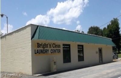
598 Coleridge Rd, Ramseur, NC 27316

Property Detail
598 Coleridge Rd
8702-71-8487
R22;W
Storebuilding
RANDOLPH
B
North Carolina
B and X Area of moderate flood hazard, usually the area between the limits of the 100-year and 500-year floods.
1.20 AC
2025
SE Randolph County
2025
Greensboro/Winston-Salem
031001
Greensboro-High Point, NC
2,016 SF
NEARBY LISTINGS FOR SALE OR LEASE
DEMOGRAPHICS near 598 Coleridge Rd
1 mile
3 mile
5 mile
2025 Total Population
2,046
5,925
11,954
2030 Population
2,091
6,102
12,306
Pop Growth 2025-2030
+ 2.20%
+ 2.99%
+ 2.94%
Average Age
42
41
40
2025 Total Households
787
2,299
4,631
HH Growth 2025-2030
+ 2.41%
+ 3.09%
+ 3.00%
Median Household Inc
$44,103
$47,956
$56,336
Avg Household Size
2.50
2.50
2.50
2025 Avg HH Vehicles
2.00
2.00
2.00
Median Home Value
$152,941
$171,035
$189,070
Median Year Built
1975
1977
1983
Nearby Places
Map Layers
Map Styles
 Street
 Aerial
Layers
 Traffic
 Biking
Places
Listings with unknown addresses are not visible on the map
- Restaurants
- Banks
- Shops
- Fitness
- Groceries
PUBLIC TRANSPORTATION
AIRPORT
Piedmont Triad International
Drive
Walk
Distance
Piedmont Triad International
57 min
41.7 mi
SALE & LEASE HISTORY
LISTING DATE
SALE/LEASE

Nov 13, 2017
For Sale
Nearby Properties
Address
Land Use
TOTAL SIZE
Lot Size
Zoning
Address
Land Use
TOTAL SIZE
Lot Size
Zoning
1,388 SF
75.55 AC
RR
Address
Land Use
TOTAL SIZE
Lot Size
Zoning
2,720 SF
138.57 AC
NR
Address
Land Use
TOTAL SIZE
Lot Size
Zoning
39,739 SF
10.60 AC
RA-20
Address
Land Use
TOTAL SIZE
Lot Size
Zoning
4.97 AC
I&C
Address
Land Use
TOTAL SIZE
Lot Size
Zoning
72,000 SF
42.04 AC
LI
Address
Land Use
TOTAL SIZE
Lot Size
Zoning
43,348 SF
39.10 AC
RR
Address
Land Use
TOTAL SIZE
Lot Size
Zoning
1.20 AC
TC
Address
Land Use
TOTAL SIZE
Lot Size
Zoning
38,612 SF
3.83 AC
B
Address
Land Use
TOTAL SIZE
Lot Size
Zoning
38,612 SF
3.76 AC
B
Address
Land Use
TOTAL SIZE
Lot Size
Zoning
11,620 SF
3.61 AC
RA
Address
Land Use
TOTAL SIZE
Lot Size
Zoning
54,690 SF
11.78 AC
I
Address
Land Use
TOTAL SIZE
Lot Size
Zoning
6,288 SF
4.30 AC
RA-16
Address
Land Use
TOTAL SIZE
Lot Size
Zoning
33,699 SF
15.01 AC
HC
Address
Land Use
TOTAL SIZE
Lot Size
Zoning
4,752 SF
4.30 AC
B
Address
Land Use
TOTAL SIZE
Lot Size
Zoning
66,166 SF
72.25 AC
I
Address
Land Use
TOTAL SIZE
Lot Size
Zoning
5,336 SF
1.95 AC
B
Address
Land Use
TOTAL SIZE
Lot Size
Zoning
6,200 SF
8.80 AC
RR
Address
Land Use
TOTAL SIZE
Lot Size
Zoning
10,806 SF
2.72 AC
B
Address
Land Use
TOTAL SIZE
Lot Size
Zoning
17,321 SF
6.21 AC
TC
Address
Land Use
TOTAL SIZE
Lot Size
Zoning
23,960 SF
12.92 AC
I
Address
Land Use
TOTAL SIZE
Lot Size
Zoning
20,720 SF
1.57 AC
I&C
Address
Land Use
TOTAL SIZE
Lot Size
Zoning
13,460 SF
0.85 AC
I&C
Address
Land Use
TOTAL SIZE
Lot Size
Zoning
3,938 SF
2.26 AC
B
Address
Land Use
TOTAL SIZE
Lot Size
Zoning
4,800 SF
97.60 AC
RA
Address
Land Use
TOTAL SIZE
Lot Size
Zoning
9,360 SF
10.03 AC
LI-CD
Address
Land Use
TOTAL SIZE
Lot Size
Zoning
43,848 SF
17.21 AC
I
Address
Land Use
TOTAL SIZE
Lot Size
Zoning
8,660 SF
0.20 AC
I&C
Address
Land Use
TOTAL SIZE
Lot Size
Zoning
9,842 SF
0.87 AC
NB
Address
Land Use
TOTAL SIZE
Lot Size
Zoning
6,912 SF
10.47 AC
HC
Address
Land Use
TOTAL SIZE
Lot Size
Zoning
25.81 AC
RM
The World's #1 Commercial Real Estate Marketplace
Connect with us
© 2026 CoStar Group
The information above has been obtained from sources believed reliable. While we do not doubt its accuracy we have not verified it and make no guarantee, warranty or representation about it. It is your responsibility to independently confirm its accuracy and completeness. Any projections, opinions, assumptions, or estimates used are for example only and do not represent the current or future performance of the property. The value of this transaction to you depends on tax and other factors which should be evaluated by your tax, financial, and legal advisors. You and your advisors should conduct a careful, independent investigation of the property to determine to your satisfaction the suitability of the property for your needs.