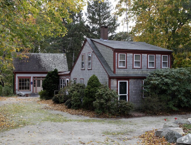
Property Record
598 Main St, Brewster, MA 02631


Property Detail
598 Main St
Commercialofficeresidentialmixeduse
Barnstable
RESD.
Massachusetts
B and X Area of moderate flood hazard, usually the area between the limits of the 100-year and 500-year floods.
0.85 AC
2025
Cape Cod
2025
Other Market Areas
010800
Barnstable Town, MA
1,682 SF
BREW-000026-000000-000069
NEARBY LISTINGS FOR SALE OR LEASE
DEMOGRAPHICS near 598 Main St
1 mile
3 mile
5 mile
2025 Total Population
941
8,420
27,659
2030 Population
945
8,478
27,971
Pop Growth 2025-2030
+ 0.43%
+ 0.69%
+ 1.13%
Average Age
52
54
53
2025 Total Households
428
4,000
12,895
HH Growth 2025-2030
+ 0.47%
+ 0.40%
+ 0.94%
Median Household Inc
$93,103
$91,271
$95,221
Avg Household Size
2.10
2.00
2.10
2025 Avg HH Vehicles
2.00
2.00
2.00
Median Home Value
$760,115
$765,102
$700,878
Median Year Built
1983
1981
1978
Nearby Places
Map Layers
Map Styles
 Street
 Aerial
Layers
 Traffic
 Biking
Places
Listings with unknown addresses are not visible on the map
- Restaurants
- Banks
- Shops
- Fitness
- Groceries
Nearby Properties
Address
Land Use
TOTAL SIZE
Lot Size
Zoning
Address
Land Use
TOTAL SIZE
Lot Size
Zoning
108,575 SF
0.48 AC
RESD.
Address
Land Use
TOTAL SIZE
Lot Size
Zoning
12.72 AC
R-60
Address
Land Use
TOTAL SIZE
Lot Size
Zoning
83,860 SF
9.96 AC
RESD.
Address
Land Use
TOTAL SIZE
Lot Size
Zoning
34.40 AC
Address
Land Use
TOTAL SIZE
Lot Size
Zoning
3.71 AC
Address
Land Use
TOTAL SIZE
Lot Size
Zoning
93,832 SF
22.68 AC
COMM H
Address
Land Use
TOTAL SIZE
Lot Size
Zoning
6,517 SF
0.14 AC
DCPC
Address
Land Use
TOTAL SIZE
Lot Size
Zoning
59,364 SF
28.65 AC
COMM H
Address
Land Use
TOTAL SIZE
Lot Size
Zoning
5.11 AC
R-60
Address
Land Use
TOTAL SIZE
Lot Size
Zoning
2.93 AC
R-60
Address
Land Use
TOTAL SIZE
Lot Size
Zoning
320 SF
9.01 AC
Address
Land Use
TOTAL SIZE
Lot Size
Zoning
8,432 SF
3.95 AC
RESD.
Address
Land Use
TOTAL SIZE
Lot Size
Zoning
Address
Land Use
TOTAL SIZE
Lot Size
Zoning
480 SF
3.33 AC
RESD.
Address
Land Use
TOTAL SIZE
Lot Size
Zoning
12,778 SF
14.40 AC
COMM H
Address
Land Use
TOTAL SIZE
Lot Size
Zoning
18.49 AC
Address
Land Use
TOTAL SIZE
Lot Size
Zoning
6.12 AC
R-60
Address
Land Use
TOTAL SIZE
Lot Size
Zoning
4 AC
R-60
Address
Land Use
TOTAL SIZE
Lot Size
Zoning
162.60 AC
Address
Land Use
TOTAL SIZE
Lot Size
Zoning
3,180 SF
2.05 AC
Address
Land Use
TOTAL SIZE
Lot Size
Zoning
6.70 AC
R-60
Address
Land Use
TOTAL SIZE
Lot Size
Zoning
4,762 SF
1.85 AC
RESD.
Address
Land Use
TOTAL SIZE
Lot Size
Zoning
135 AC
RESD.
Address
Land Use
TOTAL SIZE
Lot Size
Zoning
6,401 SF
7.07 AC
RESD.
Address
Land Use
TOTAL SIZE
Lot Size
Zoning
4,459 SF
10 AC
RESD.
Address
Land Use
TOTAL SIZE
Lot Size
Zoning
4.66 AC
R-60
Address
Land Use
TOTAL SIZE
Lot Size
Zoning
3,398 SF
1.43 AC
RESD.
Address
Land Use
TOTAL SIZE
Lot Size
Zoning
5,066 SF
38.27 AC
RESD.
Address
Land Use
TOTAL SIZE
Lot Size
Zoning
0.27 AC
R-60
Address
Land Use
TOTAL SIZE
Lot Size
Zoning
23,472 SF
13.52 AC
RESD.
The World's #1 Commercial Real Estate Marketplace
Connect with us
© 2026 CoStar Group
The information above has been obtained from sources believed reliable. While we do not doubt its accuracy we have not verified it and make no guarantee, warranty or representation about it. It is your responsibility to independently confirm its accuracy and completeness. Any projections, opinions, assumptions, or estimates used are for example only and do not represent the current or future performance of the property. The value of this transaction to you depends on tax and other factors which should be evaluated by your tax, financial, and legal advisors. You and your advisors should conduct a careful, independent investigation of the property to determine to your satisfaction the suitability of the property for your needs.