Property Record
598 Rhoads Ave, Columbus, OH 43205
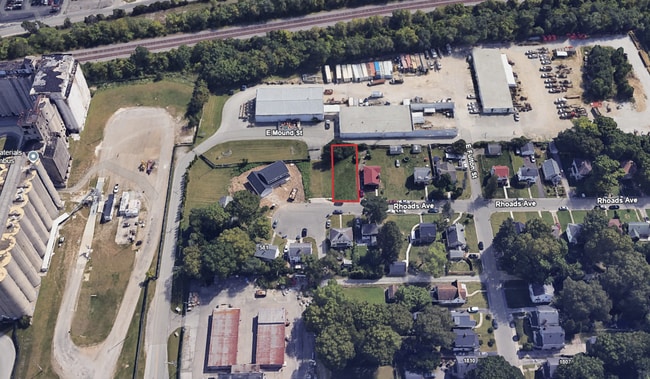


This Property Is For Sale
Property Detail
598 Rhoads Ave
Columbus, OH
598-600 RHOADS PL RHOADS PLACE LOT 40
010-002618
Franklin
Residentialacreage
Ohio
2024
40
2025
0.11 AC
005410
Downtown East
1,568 SF
Columbus
NEARBY LISTINGS FOR SALE OR LEASE
DEMOGRAPHICS near 598 Rhoads Ave
1 mile
3 mile
5 mile
2025 Total Population
19,839
138,971
336,319
2030 Population
21,303
146,110
351,248
Pop Growth 2025-2030
+ 7.38%
+ 5.14%
+ 4.44%
Average Age
37
38
36
2025 Total Households
8,091
63,262
141,733
HH Growth 2025-2030
+ 7.95%
+ 5.38%
+ 4.77%
Median Household Inc
$57,638
$56,732
$53,088
Avg Household Size
2.20
2.10
2.20
2025 Avg HH Vehicles
2.00
1.00
1.00
Median Home Value
$378,237
$305,293
$250,738
Median Year Built
1950
1956
1963
Nearby Places
Map Layers
Map Styles
 Street
 Aerial
Layers
 Traffic
 Biking
Places
Listings with unknown addresses are not visible on the map
- Restaurants
- Banks
- Shops
- Fitness
- Groceries
PUBLIC TRANSPORTATION
AIRPORT
John Glenn Columbus International
Drive
Walk
Distance
John Glenn Columbus International
11 min
5.9 mi
Rickenbacker International
Drive
Walk
Distance
Rickenbacker International
20 min
10.7 mi
Freight Ports
Port of Toledo
Drive
Walk
Distance
Port of Toledo
188 min
151.7 mi
Nearby Properties
Address
Land Use
TOTAL SIZE
Lot Size
Zoning
Address
Land Use
TOTAL SIZE
Lot Size
Zoning
1,949,795 SF
20.56 AC
Address
Land Use
TOTAL SIZE
Lot Size
Zoning
1,467,891 SF
10.49 AC
Address
Land Use
TOTAL SIZE
Lot Size
Zoning
304,340 SF
3.86 AC
Address
Land Use
TOTAL SIZE
Lot Size
Zoning
477,854 SF
0.72 AC
Address
Land Use
TOTAL SIZE
Lot Size
Zoning
798,272 SF
9.94 AC
Address
Land Use
TOTAL SIZE
Lot Size
Zoning
832,673 SF
2.87 AC
Address
Land Use
TOTAL SIZE
Lot Size
Zoning
972,594 SF
0.84 AC
Address
Land Use
TOTAL SIZE
Lot Size
Zoning
481,704 SF
0.92 AC
Address
Land Use
TOTAL SIZE
Lot Size
Zoning
1,113,919 SF
1.63 AC
Address
Land Use
TOTAL SIZE
Lot Size
Zoning
1,462,053 SF
0.21 AC
Address
Land Use
TOTAL SIZE
Lot Size
Zoning
484,662 SF
2.28 AC
Address
Land Use
TOTAL SIZE
Lot Size
Zoning
470,630 SF
0.57 AC
Address
Land Use
TOTAL SIZE
Lot Size
Zoning
339,231 SF
0.73 AC
Address
Land Use
TOTAL SIZE
Lot Size
Zoning
1,013,906 SF
1 AC
Address
Land Use
TOTAL SIZE
Lot Size
Zoning
1,158,978 SF
5.02 AC
Address
Land Use
TOTAL SIZE
Lot Size
Zoning
669,626 SF
0.97 AC
Address
Land Use
TOTAL SIZE
Lot Size
Zoning
892,833 SF
5.27 AC
Address
Land Use
TOTAL SIZE
Lot Size
Zoning
560,146 SF
63.19 AC
Address
Land Use
TOTAL SIZE
Lot Size
Zoning
459,012 SF
3.71 AC
Address
Land Use
TOTAL SIZE
Lot Size
Zoning
697,192 SF
2.72 AC
Address
Land Use
TOTAL SIZE
Lot Size
Zoning
800,977 SF
0.77 AC
Address
Land Use
TOTAL SIZE
Lot Size
Zoning
180,636 SF
4.33 AC
Address
Land Use
TOTAL SIZE
Lot Size
Zoning
242,613 SF
0.10 AC
Address
Land Use
TOTAL SIZE
Lot Size
Zoning
122,019 SF
0.92 AC
Address
Land Use
TOTAL SIZE
Lot Size
Zoning
184,777 SF
3.67 AC
Address
Land Use
TOTAL SIZE
Lot Size
Zoning
361,680 SF
4.12 AC
Address
Land Use
TOTAL SIZE
Lot Size
Zoning
573,031 SF
5.88 AC
Address
Land Use
TOTAL SIZE
Lot Size
Zoning
472,650 SF
1.65 AC
Address
Land Use
TOTAL SIZE
Lot Size
Zoning
301,882 SF
1.13 AC
Address
Land Use
TOTAL SIZE
Lot Size
Zoning
496,729 SF
3.47 AC
The World's #1 Commercial Real Estate Marketplace
Connect with us
© 2026 CoStar Group
The information above has been obtained from sources believed reliable. While we do not doubt its accuracy we have not verified it and make no guarantee, warranty or representation about it. It is your responsibility to independently confirm its accuracy and completeness. Any projections, opinions, assumptions, or estimates used are for example only and do not represent the current or future performance of the property. The value of this transaction to you depends on tax and other factors which should be evaluated by your tax, financial, and legal advisors. You and your advisors should conduct a careful, independent investigation of the property to determine to your satisfaction the suitability of the property for your needs.