Property Record
5980 66Th St N, Saint Petersburg, FL 33709
NEARBY LISTINGS FOR SALE OR LEASE
Property Detail
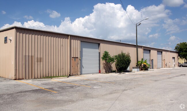
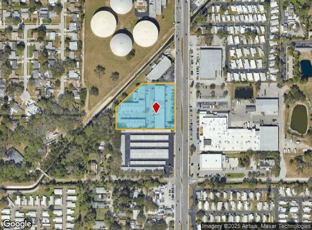
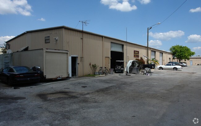
5980 66Th St N
Tampa-St. Petersburg-Clearwater, FL
Hiland Square
31-30-16-39636-001-0010
HILAND SQUARE BLK A, LOTS 1 TO 7 & 24 TO 30 INCL., & BLK B, LOTS 1 TO 7 & 24 TO 27 INCL AND VAC ST ON N & VAC ST BETWEEN BLK A & B
Regionalshoppingcenterormallwithanchorstore
Pinellas
AE
Florida
12103C0203J
1
2024
2.55 AC
2025
South Pinellas
025018
Tampa/St Petersburg
36,752 SF
DEMOGRAPHICS near 5980 66Th St N
1 Mile
3 Mile
5 Mile
2024 Total Population
14,213
111,569
261,516
2029 Population
14,263
111,637
262,280
Pop Growth 2024-2029
+ 0.35%
+ 0.06%
+ 0.29%
Average Age
43
44
46
2024 Total Households
5,615
47,670
118,699
HH Growth 2024-2029
+ 0.09%
(0.10%)
+ 0.26%
Median Household Inc
$54,334
$56,459
$59,292
Avg Household Size
2.40
2.20
2.10
2024 Avg HH Vehicles
2.00
2.00
2.00
Median Home Value
$219,234
$228,823
$244,269
Median Year Built
1973
1971
1971
Nearby Places
Map Layers
Map Styles
 Street
 Aerial
- Restaurants
- Banks
- Shops
- Fitness
- Groceries
PUBLIC TRANSPORTATION
AIRPORT
St Pete-Clearwater International
DRIVE
WALK
Distance
St Pete-Clearwater International
22 min
9.7 mi
Tampa International
DRIVE
WALK
Distance
Tampa International
32 min
20.2 mi
Freight Ports
Port Manatee
DRIVE
WALK
Distance
Port Manatee
44 min
32.1 mi
Nearby Properties
Address
Land Use
TOTAL SIZE
Lot Size
Zoning
Address
Land Use
TOTAL SIZE
Lot Size
Zoning
459,848 SF
19.74 AC
R6
Address
Land Use
TOTAL SIZE
Lot Size
Zoning
372,013 SF
10.10 AC
Address
Land Use
TOTAL SIZE
Lot Size
Zoning
738,882 SF
43.34 AC
Address
Land Use
TOTAL SIZE
Lot Size
Zoning
404,899 SF
35.35 AC
Address
Land Use
TOTAL SIZE
Lot Size
Zoning
358,681 SF
11.70 AC
Address
Land Use
TOTAL SIZE
Lot Size
Zoning
396,428 SF
19.76 AC
Address
Land Use
TOTAL SIZE
Lot Size
Zoning
206,685 SF
16.75 AC
RPD5
Address
Land Use
TOTAL SIZE
Lot Size
Zoning
267,649 SF
17.86 AC
Address
Land Use
TOTAL SIZE
Lot Size
Zoning
127,237 SF
10.53 AC
Address
Land Use
TOTAL SIZE
Lot Size
Zoning
150,235 SF
17.90 AC
Address
Land Use
TOTAL SIZE
Lot Size
Zoning
195,863 SF
18.57 AC
Address
Land Use
TOTAL SIZE
Lot Size
Zoning
193,194 SF
13.53 AC
Address
Land Use
TOTAL SIZE
Lot Size
Zoning
360,137 SF
37.64 AC
AE
Address
Land Use
TOTAL SIZE
Lot Size
Zoning
172,600 SF
20.57 AC
Address
Land Use
TOTAL SIZE
Lot Size
Zoning
172,768 SF
15.05 AC
RPD20
Address
Land Use
TOTAL SIZE
Lot Size
Zoning
125,218 SF
13.51 AC
Address
Land Use
TOTAL SIZE
Lot Size
Zoning
116,358 SF
12.74 AC
Address
Land Use
TOTAL SIZE
Lot Size
Zoning
248,572 SF
15.22 AC
PSP
Address
Land Use
TOTAL SIZE
Lot Size
Zoning
48,862 SF
3.72 AC
Address
Land Use
TOTAL SIZE
Lot Size
Zoning
145,047 SF
12.03 AC
Address
Land Use
TOTAL SIZE
Lot Size
Zoning
154,986 SF
11.08 AC
Address
Land Use
TOTAL SIZE
Lot Size
Zoning
46,749 SF
5.80 AC
Address
Land Use
TOTAL SIZE
Lot Size
Zoning
49,898 SF
77.25 AC
Address
Land Use
TOTAL SIZE
Lot Size
Zoning
89,316 SF
9.24 AC
Address
Land Use
TOTAL SIZE
Lot Size
Zoning
119,580 SF
4.18 AC
Address
Land Use
TOTAL SIZE
Lot Size
Zoning
137,240 SF
11.38 AC
RPD125
Address
Land Use
TOTAL SIZE
Lot Size
Zoning
99,045 SF
8.79 AC
Address
Land Use
TOTAL SIZE
Lot Size
Zoning
151,193 SF
23.54 AC
Address
Land Use
TOTAL SIZE
Lot Size
Zoning
90,145 SF
3.46 AC
Address
Land Use
TOTAL SIZE
Lot Size
Zoning
159,218 SF
12.48 AC
The World's #1 Commercial Real Estate Marketplace
Connect with us
© 2025 CoStar Group
The information above has been obtained from sources believed reliable. While we do not doubt its accuracy we have not verified it and make no guarantee, warranty or representation about it. It is your responsibility to independently confirm its accuracy and completeness. Any projections, opinions, assumptions, or estimates used are for example only and do not represent the current or future performance of the property. The value of this transaction to you depends on tax and other factors which should be evaluated by your tax, financial, and legal advisors. You and your advisors should conduct a careful, independent investigation of the property to determine to your satisfaction the suitability of the property for your needs.