Property Record
5985 Monterey Rd, Paso Robles, CA 93446

Save to a Folder
{{folder.Name}}
{{folder.ListingIds.length}} Properties
{{folder.ListingIds.length}} Property
Create a New Folder
Property Detail
5985 Monterey Rd
San Luis Obispo-Paso Robles, CA
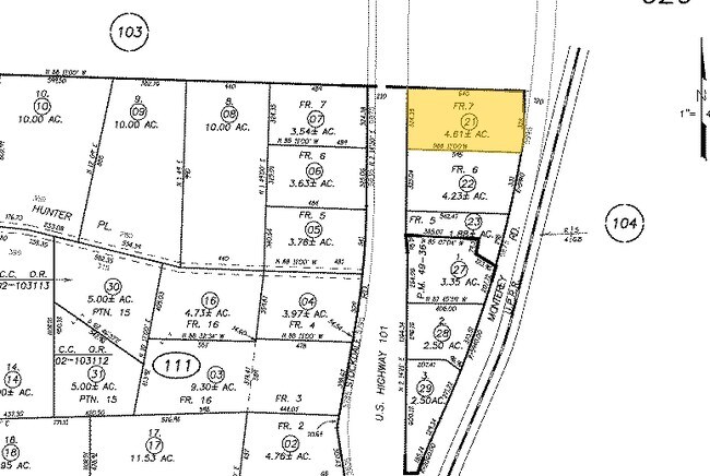
RIVER GLEN ORCH PTN LT 7 & PTN ABD RD
026-111-021
SAN LUIS OBISPO
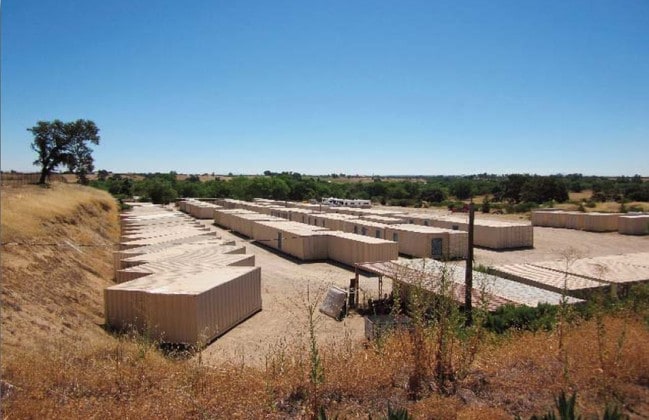
Commercialacreage
California
CS
7
B and X Area of moderate flood hazard, usually the area between the limits of the 100-year and 500-year floods.
4.61 AC
2024
North 101 Corridor
2025
San Luis Obispo/Paso Robles
010016
NEARBY LISTINGS FOR SALE OR LEASE
DEMOGRAPHICS near 5985 Monterey Rd
1 mile
3 mile
5 mile
2025 Total Population
371
4,893
21,705
2030 Population
349
4,818
21,420
Pop Growth 2025-2030
(5.93%)
(1.53%)
(1.31%)
Average Age
44
39
39
2025 Total Households
133
1,786
7,968
HH Growth 2025-2030
(6.02%)
(1.79%)
(1.33%)
Median Household Inc
$100,431
$73,202
$88,687
Avg Household Size
2.80
2.70
2.70
2025 Avg HH Vehicles
3.00
2.00
2.00
Median Home Value
$949,999
$767,523
$732,471
Median Year Built
1993
1994
1987
Nearby Places
Map Layers
Map Styles
 Street
 Aerial
Layers
 Traffic
 Biking
Places
Listings with unknown addresses are not visible on the map
- Restaurants
- Banks
- Shops
- Fitness
- Groceries
PUBLIC TRANSPORTATION
COMMUTER RAIL
Paso Robles Amtrak Station (Coast Starlight - Amtrak)
Drive
Walk
Distance
Paso Robles Amtrak Station (Coast Starlight - Amtrak)
8 min
6.1 mi
Freight Ports
The Port of Hueneme
Drive
Walk
Distance
The Port of Hueneme
208 min
166.7 mi
Nearby Properties
Address
Land Use
TOTAL SIZE
Lot Size
Zoning
Address
Land Use
TOTAL SIZE
Lot Size
Zoning
127,770 SF
27.72 AC
AG
Address
Land Use
TOTAL SIZE
Lot Size
Zoning
58,884 SF
2.34 AC
T4N
Address
Land Use
TOTAL SIZE
Lot Size
Zoning
89,417 SF
3.13 AC
T4N
Address
Land Use
TOTAL SIZE
Lot Size
Zoning
64,323 SF
2.56 AC
T4N
Address
Land Use
TOTAL SIZE
Lot Size
Zoning
2,351 SF
156.09 AC
AG
Address
Land Use
TOTAL SIZE
Lot Size
Zoning
54,961 SF
2.93 AC
T4N
Address
Land Use
TOTAL SIZE
Lot Size
Zoning
1,284 SF
84 AC
AG
Address
Land Use
TOTAL SIZE
Lot Size
Zoning
Address
Land Use
TOTAL SIZE
Lot Size
Zoning
22,528 SF
1.53 AC
T4N
Address
Land Use
TOTAL SIZE
Lot Size
Zoning
9.93 AC
CS
Address
Land Use
TOTAL SIZE
Lot Size
Zoning
0.91 AC
R4
Address
Land Use
TOTAL SIZE
Lot Size
Zoning
35,020 SF
1.41 AC
C2
Address
Land Use
TOTAL SIZE
Lot Size
Zoning
13,134 SF
10.82 AC
AG
Address
Land Use
TOTAL SIZE
Lot Size
Zoning
167,148 SF
7.36 AC
RSC
Address
Land Use
TOTAL SIZE
Lot Size
Zoning
158.70 AC
AG
Address
Land Use
TOTAL SIZE
Lot Size
Zoning
8,159 SF
0.54 AC
T4F
Address
Land Use
TOTAL SIZE
Lot Size
Zoning
59.99 AC
AG
Address
Land Use
TOTAL SIZE
Lot Size
Zoning
1,471 SF
25.70 AC
AG
Address
Land Use
TOTAL SIZE
Lot Size
Zoning
17,306 SF
0.28 AC
T4NC
Address
Land Use
TOTAL SIZE
Lot Size
Zoning
175.72 AC
AG
Address
Land Use
TOTAL SIZE
Lot Size
Zoning
30,000 SF
1.65 AC
IND
Address
Land Use
TOTAL SIZE
Lot Size
Zoning
119.90 AC
AG
Address
Land Use
TOTAL SIZE
Lot Size
Zoning
6,404 SF
1.96 AC
T4N
Address
Land Use
TOTAL SIZE
Lot Size
Zoning
91.91 AC
AG
Address
Land Use
TOTAL SIZE
Lot Size
Zoning
1,954 SF
5.65 AC
CS
Address
Land Use
TOTAL SIZE
Lot Size
Zoning
30 AC
AG
Address
Land Use
TOTAL SIZE
Lot Size
Zoning
3.93 AC
CS
Address
Land Use
TOTAL SIZE
Lot Size
Zoning
9,266 SF
0.44 AC
R4
Address
Land Use
TOTAL SIZE
Lot Size
Zoning
9,006 SF
0.30 AC
R4
Address
Land Use
TOTAL SIZE
Lot Size
Zoning
80.56 AC
AG
The World's #1 Commercial Real Estate Marketplace
Connect with us
© 2026 CoStar Group
The information above has been obtained from sources believed reliable. While we do not doubt its accuracy we have not verified it and make no guarantee, warranty or representation about it. It is your responsibility to independently confirm its accuracy and completeness. Any projections, opinions, assumptions, or estimates used are for example only and do not represent the current or future performance of the property. The value of this transaction to you depends on tax and other factors which should be evaluated by your tax, financial, and legal advisors. You and your advisors should conduct a careful, independent investigation of the property to determine to your satisfaction the suitability of the property for your needs.