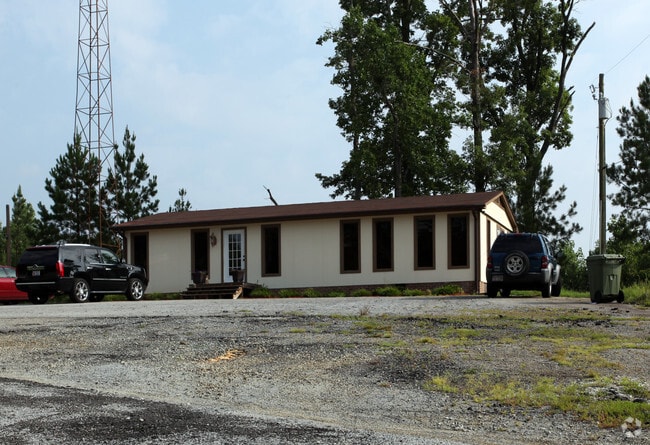
Property Record
5985 Old Mendenhall Rd, High Point, NC 27263


Save to a Folder
{{folder.Name}}
{{folder.ListingIds.length}} Properties
{{folder.ListingIds.length}} Property
Create a New Folder
Property Detail
5985 Old Mendenhall Rd
6798-77-9874
R1616;W BOTH
Officebuilding
Randolph
LI-CZ
North Carolina
AE The base floodplain where base flood elevations are provided. AE Zones are now used on new format FIRMs instead of A1-A30 Zones.
24.34 AC
2025
NW Randolph Cnty/Archdale
2025
Greensboro/Winston-Salem
031601
Greensboro-High Point, NC
1,152 SF
NEARBY LISTINGS FOR SALE OR LEASE
DEMOGRAPHICS near 5985 Old Mendenhall Rd
1 mile
3 mile
5 mile
2025 Total Population
1,022
29,997
96,959
2030 Population
1,070
31,200
100,812
Pop Growth 2025-2030
+ 4.70%
+ 4.01%
+ 3.97%
Average Age
42
39
39
2025 Total Households
434
12,048
37,069
HH Growth 2025-2030
+ 4.61%
+ 4.07%
+ 4.19%
Median Household Inc
$34,604
$52,294
$53,962
Avg Household Size
2.30
2.40
2.40
2025 Avg HH Vehicles
2.00
2.00
2.00
Median Home Value
$172,839
$181,307
$192,289
Median Year Built
1978
1978
1972
Nearby Places
Map Layers
Map Styles
 Street
 Aerial
Layers
 Traffic
 Biking
Places
Listings with unknown addresses are not visible on the map
- Restaurants
- Banks
- Shops
- Fitness
- Groceries
PUBLIC TRANSPORTATION
COMMUTER RAIL
High Point (Carolinian - Amtrak, Crescent - Amtrak, Piedmont - Amtrak)
Drive
Walk
Distance
High Point (Carolinian - Amtrak, Crescent - Amtrak, Piedmont - Amtrak)
10 min
4.9 mi
AIRPORT
Piedmont Triad International
Drive
Walk
Distance
Piedmont Triad International
34 min
17.0 mi
Freight Ports
Port of Wilmington
Drive
Walk
Distance
Port of Wilmington
254 min
213.3 mi
SALE & LEASE HISTORY
LISTING DATE
SALE/LEASE

Mar 09, 2021
For Sale
Nearby Properties
Address
Land Use
TOTAL SIZE
Lot Size
Zoning
Address
Land Use
TOTAL SIZE
Lot Size
Zoning
104,686 SF
12.97 AC
GB
Address
Land Use
TOTAL SIZE
Lot Size
Zoning
355,633 SF
63.42 AC
HI
Address
Land Use
TOTAL SIZE
Lot Size
Zoning
204,276 SF
68.51 AC
M-2
Address
Land Use
TOTAL SIZE
Lot Size
Zoning
196,353 SF
13.76 AC
RC
Address
Land Use
TOTAL SIZE
Lot Size
Zoning
156,010 SF
36.21 AC
M-1
Address
Land Use
TOTAL SIZE
Lot Size
Zoning
351,736 SF
34.77 AC
HI
Address
Land Use
TOTAL SIZE
Lot Size
Zoning
127,800 SF
57.35 AC
M-1
Address
Land Use
TOTAL SIZE
Lot Size
Zoning
174,529 SF
2.87 AC
CB
Address
Land Use
TOTAL SIZE
Lot Size
Zoning
105,676 SF
24.20 AC
R-5
Address
Land Use
TOTAL SIZE
Lot Size
Zoning
85,233 SF
4.56 AC
CU-PDM
Address
Land Use
TOTAL SIZE
Lot Size
Zoning
245,194 SF
23.44 AC
LI
Address
Land Use
TOTAL SIZE
Lot Size
Zoning
85,233 SF
4.36 AC
CU-PDM
Address
Land Use
TOTAL SIZE
Lot Size
Zoning
69,113 SF
7.87 AC
CU-PDM
Address
Land Use
TOTAL SIZE
Lot Size
Zoning
101,797 SF
11.15 AC
PD-P
Address
Land Use
TOTAL SIZE
Lot Size
Zoning
107,417 SF
6.46 AC
RM-26
Address
Land Use
TOTAL SIZE
Lot Size
Zoning
101,612 SF
15.82 AC
RM-16
Address
Land Use
TOTAL SIZE
Lot Size
Zoning
111,312 SF
7.98 AC
RM-26
Address
Land Use
TOTAL SIZE
Lot Size
Zoning
62,012 SF
6.09 AC
CU-PDM
Address
Land Use
TOTAL SIZE
Lot Size
Zoning
426,585 SF
27.46 AC
HI
Address
Land Use
TOTAL SIZE
Lot Size
Zoning
240,124 SF
9.43 AC
HI
Address
Land Use
TOTAL SIZE
Lot Size
Zoning
170,516 SF
17.08 AC
RC
Address
Land Use
TOTAL SIZE
Lot Size
Zoning
223,806 SF
12.60 AC
HI
Address
Land Use
TOTAL SIZE
Lot Size
Zoning
82,160 SF
23.62 AC
C2
Address
Land Use
TOTAL SIZE
Lot Size
Zoning
221,890 SF
2.95 AC
CB
Address
Land Use
TOTAL SIZE
Lot Size
Zoning
10,810 SF
158.27 AC
PNR
Address
Land Use
TOTAL SIZE
Lot Size
Zoning
27,310 SF
20.06 AC
HI
Address
Land Use
TOTAL SIZE
Lot Size
Zoning
109,950 SF
28.29 AC
M-1
Address
Land Use
TOTAL SIZE
Lot Size
Zoning
28.20 AC
RR
Address
Land Use
TOTAL SIZE
Lot Size
Zoning
493,334 SF
7.40 AC
LI
Address
Land Use
TOTAL SIZE
Lot Size
Zoning
121,473 SF
32.77 AC
RM-16
The World's #1 Commercial Real Estate Marketplace
Connect with us
© 2026 CoStar Group
The information above has been obtained from sources believed reliable. While we do not doubt its accuracy we have not verified it and make no guarantee, warranty or representation about it. It is your responsibility to independently confirm its accuracy and completeness. Any projections, opinions, assumptions, or estimates used are for example only and do not represent the current or future performance of the property. The value of this transaction to you depends on tax and other factors which should be evaluated by your tax, financial, and legal advisors. You and your advisors should conduct a careful, independent investigation of the property to determine to your satisfaction the suitability of the property for your needs.