Property Record
5988 Summit Bridge Rd, Townsend, DE 19734
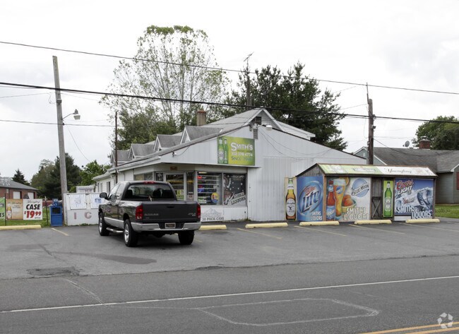

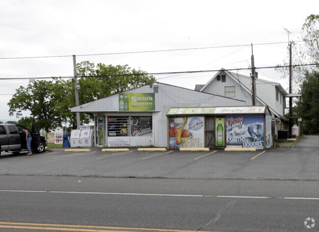
Property Detail
5988 Summit Bridge Rd
25-002.00-096
BEG AT POINT ON SWLY SIDE OF SUMMIT BRIDGE RD DELAWARE ROUTE 896 AT VARYING WIDT
Storebuilding
NEW CASTLE
25C
Delaware
B and X Area of moderate flood hazard, usually the area between the limits of the 100-year and 500-year floods.
1
2024
0.83 AC
2024
South New Castle County
016806
Philadelphia
6,111 SF
Philadelphia-Camden-Wilmington, PA-NJ-DE-MD
NEARBY LISTINGS FOR SALE OR LEASE
-
-
View all Townsend listings for sale on LoopNet.com
DEMOGRAPHICS near 5988 Summit Bridge Rd
1 mile
3 mile
5 mile
2024 Total Population
3,067
12,929
41,081
2029 Population
3,223
13,508
42,665
Pop Growth 2024-2029
+ 5.09%
+ 4.48%
+ 3.86%
Average Age
37
39
39
2024 Total Households
886
3,954
13,514
HH Growth 2024-2029
+ 5.42%
+ 4.68%
+ 4.05%
Median Household Inc
$139,642
$138,875
$122,098
Avg Household Size
3.30
3.10
2.90
2024 Avg HH Vehicles
2.00
2.00
2.00
Median Home Value
$462,419
$469,499
$444,207
Median Year Built
2005
2005
2003
Nearby Places
Map Layers
Map Styles
 Street
 Aerial
Transit
 Traffic
 Biking
Places
Listings with unknown addresses are not visible on the map
- Restaurants
- Banks
- Shops
- Fitness
- Groceries
Nearby Properties
Address
Land Use
TOTAL SIZE
Lot Size
Zoning
Address
Land Use
TOTAL SIZE
Lot Size
Zoning
Address
Land Use
TOTAL SIZE
Lot Size
Zoning
42.51 AC
23R-1A
Address
Land Use
TOTAL SIZE
Lot Size
Zoning
Address
Land Use
TOTAL SIZE
Lot Size
Zoning
504 SF
10.34 AC
25C
Address
Land Use
TOTAL SIZE
Lot Size
Zoning
6,000 SF
83.33 AC
SR
Address
Land Use
TOTAL SIZE
Lot Size
Zoning
Address
Land Use
TOTAL SIZE
Lot Size
Zoning
600 SF
284.46 AC
S
Address
Land Use
TOTAL SIZE
Lot Size
Zoning
Address
Land Use
TOTAL SIZE
Lot Size
Zoning
Address
Land Use
TOTAL SIZE
Lot Size
Zoning
Address
Land Use
TOTAL SIZE
Lot Size
Zoning
1.95 AC
25C
Address
Land Use
TOTAL SIZE
Lot Size
Zoning
40,000 SF
3.50 AC
23C-2
Address
Land Use
TOTAL SIZE
Lot Size
Zoning
Address
Land Use
TOTAL SIZE
Lot Size
Zoning
Address
Land Use
TOTAL SIZE
Lot Size
Zoning
11,862 SF
143.36 AC
23R-1B
Address
Land Use
TOTAL SIZE
Lot Size
Zoning
47,208 SF
5.05 AC
CR
Address
Land Use
TOTAL SIZE
Lot Size
Zoning
59,894 SF
11.46 AC
I
Address
Land Use
TOTAL SIZE
Lot Size
Zoning
3,920 SF
7.12 AC
NC21
Address
Land Use
TOTAL SIZE
Lot Size
Zoning
Address
Land Use
TOTAL SIZE
Lot Size
Zoning
2,160 SF
3.04 AC
25I
Address
Land Use
TOTAL SIZE
Lot Size
Zoning
Address
Land Use
TOTAL SIZE
Lot Size
Zoning
7,339 SF
4.42 AC
S
Address
Land Use
TOTAL SIZE
Lot Size
Zoning
9,982 SF
1.64 AC
25C
Address
Land Use
TOTAL SIZE
Lot Size
Zoning
16.10 AC
S
Address
Land Use
TOTAL SIZE
Lot Size
Zoning
7,137 SF
1.92 AC
OR
Address
Land Use
TOTAL SIZE
Lot Size
Zoning
9,916 SF
1.70 AC
25C
Address
Land Use
TOTAL SIZE
Lot Size
Zoning
9,260 SF
1.14 AC
25C
Address
Land Use
TOTAL SIZE
Lot Size
Zoning
Address
Land Use
TOTAL SIZE
Lot Size
Zoning
5,840 SF
2.43 AC
OR
Address
Land Use
TOTAL SIZE
Lot Size
Zoning
9,920 SF
1.84 AC
23R-2
The World's #1 Commercial Real Estate Marketplace
Connect with us
© 2026 CoStar Group
The information above has been obtained from sources believed reliable. While we do not doubt its accuracy we have not verified it and make no guarantee, warranty or representation about it. It is your responsibility to independently confirm its accuracy and completeness. Any projections, opinions, assumptions, or estimates used are for example only and do not represent the current or future performance of the property. The value of this transaction to you depends on tax and other factors which should be evaluated by your tax, financial, and legal advisors. You and your advisors should conduct a careful, independent investigation of the property to determine to your satisfaction the suitability of the property for your needs.