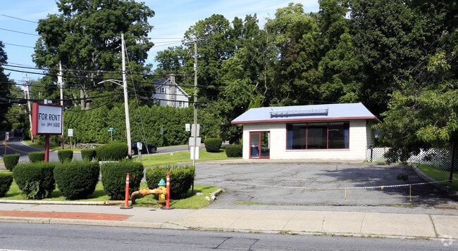
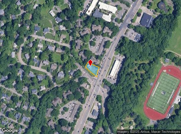
Property Record
599 Central Park Ave, Scarsdale, NY 10583
NEARBY LISTINGS FOR SALE OR LEASE
-
-
-
-
No Photo
-
-
-
-
View all Scarsdale listings for lease on LoopNet.com
Property Detail
599 Central Park Ave
2689-008-410-00298-000-0001
Westchester
Storesoffices
New York
X
1.000
36119C0264F
0.22 AC
2025
Southwest
2024
Westchester/So Connecticut
010801
New York-Jersey City-White Plains, NY-NJ
DEMOGRAPHICS near 599 Central Park Ave
1 Mile
3 Mile
5 Mile
2024 Total Population
9,814
119,697
298,345
2029 Population
9,626
117,771
292,789
Pop Growth 2024-2029
(1.92%)
(1.61%)
(1.86%)
Average Age
41
42
43
2024 Total Households
3,238
43,013
112,415
HH Growth 2024-2029
(1.98%)
(1.65%)
(1.91%)
Median Household Inc
$220,665
$152,596
$137,837
Avg Household Size
2.90
2.70
2.60
2024 Avg HH Vehicles
2.00
2.00
2.00
Median Home Value
$1,042,166
$739,169
$687,914
Median Year Built
1956
1956
1957
Nearby Places
- Restaurants
- Banks
- Shops
- Fitness
- Groceries
PUBLIC TRANSPORTATION
COMMUTER RAIL
Scarsdale Station (Harlem Line - Metro-North Commuter Railroad Company (Metro-North))
DRIVE
WALK
Distance
Scarsdale Station (Harlem Line - Metro-North Commuter Railroad Company (Metro-North))
4 min
1.3 mi
Hartsdale Station (Harlem Line - Metro-North Commuter Railroad Company (Metro-North))
DRIVE
WALK
Distance
Hartsdale Station (Harlem Line - Metro-North Commuter Railroad Company (Metro-North))
6 min
2.1 mi
AIRPORT
Westchester County
DRIVE
WALK
Distance
Westchester County
21 min
9.6 mi
LaGuardia
DRIVE
WALK
Distance
LaGuardia
37 min
21.5 mi
John F Kennedy International
DRIVE
WALK
Distance
John F Kennedy International
45 min
29.3 mi
Freight Ports
NY - Red Hook Container Terminal
DRIVE
WALK
Distance
NY - Red Hook Container Terminal
50 min
29.6 mi
SALE & LEASE HISTORY
LISTING DATE
SALE/LEASE

May 17, 2023
For Lease
Mar 21, 2024
For Lease
Nearby Properties
Address
Land Use
TOTAL SIZE
Lot Size
Zoning
Address
Land Use
TOTAL SIZE
Lot Size
Zoning
88.45 AC
Address
Land Use
TOTAL SIZE
Lot Size
Zoning
Address
Land Use
TOTAL SIZE
Lot Size
Zoning
381,836 SF
16.68 AC
A3
Address
Land Use
TOTAL SIZE
Lot Size
Zoning
63.48 AC
R-30
Address
Land Use
TOTAL SIZE
Lot Size
Zoning
66 AC
R-20
Address
Land Use
TOTAL SIZE
Lot Size
Zoning
101.99 AC
Address
Land Use
TOTAL SIZE
Lot Size
Zoning
237,313 SF
22.67 AC
A1
Address
Land Use
TOTAL SIZE
Lot Size
Zoning
Address
Land Use
TOTAL SIZE
Lot Size
Zoning
13.22 AC
CA
Address
Land Use
TOTAL SIZE
Lot Size
Zoning
29.81 AC
Address
Land Use
TOTAL SIZE
Lot Size
Zoning
68,911 SF
16.31 AC
Address
Land Use
TOTAL SIZE
Lot Size
Zoning
16.22 AC
UR
Address
Land Use
TOTAL SIZE
Lot Size
Zoning
77.52 AC
A3
Address
Land Use
TOTAL SIZE
Lot Size
Zoning
8.42 AC
Address
Land Use
TOTAL SIZE
Lot Size
Zoning
Address
Land Use
TOTAL SIZE
Lot Size
Zoning
22.44 AC
R-20
Address
Land Use
TOTAL SIZE
Lot Size
Zoning
14.92 AC
Address
Land Use
TOTAL SIZE
Lot Size
Zoning
7.98 AC
CA
Address
Land Use
TOTAL SIZE
Lot Size
Zoning
1,975 SF
13.80 AC
CA
Address
Land Use
TOTAL SIZE
Lot Size
Zoning
1.65 AC
Address
Land Use
TOTAL SIZE
Lot Size
Zoning
10.90 AC
UR
Address
Land Use
TOTAL SIZE
Lot Size
Zoning
11.18 AC
Address
Land Use
TOTAL SIZE
Lot Size
Zoning
64.41 AC
R-20
Address
Land Use
TOTAL SIZE
Lot Size
Zoning
48,499 SF
8.52 AC
A2/A3
Address
Land Use
TOTAL SIZE
Lot Size
Zoning
1,200 SF
21.21 AC
R-20
Address
Land Use
TOTAL SIZE
Lot Size
Zoning
61,606 SF
19.99 AC
A4/A3
Address
Land Use
TOTAL SIZE
Lot Size
Zoning
98,910 SF
0.91 AC
VCR-0
Address
Land Use
TOTAL SIZE
Lot Size
Zoning
18.72 AC
Address
Land Use
TOTAL SIZE
Lot Size
Zoning
48,267 SF
11.04 AC
A2 A
Address
Land Use
TOTAL SIZE
Lot Size
Zoning
1,823 SF
6.89 AC
The World's #1 Commercial Real Estate Marketplace
Connect with us
© 2025 CoStar Group
The information above has been obtained from sources believed reliable. While we do not doubt its accuracy we have not verified it and make no guarantee, warranty or representation about it. It is your responsibility to independently confirm its accuracy and completeness. Any projections, opinions, assumptions, or estimates used are for example only and do not represent the current or future performance of the property. The value of this transaction to you depends on tax and other factors which should be evaluated by your tax, financial, and legal advisors. You and your advisors should conduct a careful, independent investigation of the property to determine to your satisfaction the suitability of the property for your needs.