Property Record
599 Norwood Dr, Wampum, PA 16157

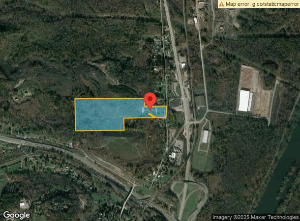
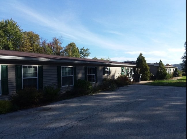
This Property Is For Sale
NEARBY LISTINGS FOR SALE OR LEASE
-
-
View all Wampum listings for sale on LoopNet.com
Property Detail
599 Norwood Dr
53-113-0381.000
Betters Conway Plan 01
Commercialnec
25.6 AC BLDGS
X
Beaver
42007C0054D
Pennsylvania
2024
25.60 AC
2025
Beaver County
408300
Pittsburgh
7,276 SF
Pittsburgh, PA
DEMOGRAPHICS near 599 Norwood Dr
1 Mile
3 Mile
5 Mile
2024 Total Population
776
7,723
41,505
2029 Population
755
7,544
40,754
Pop Growth 2024-2029
(2.71%)
(2.32%)
(1.81%)
Average Age
46
43
43
2024 Total Households
365
3,255
17,286
HH Growth 2024-2029
(2.74%)
(2.37%)
(1.87%)
Median Household Inc
$56,951
$61,344
$65,651
Avg Household Size
2.10
2.30
2.30
2024 Avg HH Vehicles
2.00
2.00
2.00
Median Home Value
$99,626
$131,818
$151,415
Median Year Built
1948
1951
1953
Nearby Places
Map Layers
Map Styles
 Street
 Aerial
- Restaurants
- Banks
- Shops
- Fitness
- Groceries
PUBLIC TRANSPORTATION
AIRPORT
Pittsburgh International
DRIVE
WALK
Distance
Pittsburgh International
45 min
30.3 mi
Freight Ports
Port of Toledo
DRIVE
WALK
Distance
Port of Toledo
224 min
196.8 mi
Nearby Properties
Address
Land Use
TOTAL SIZE
Lot Size
Zoning
Address
Land Use
TOTAL SIZE
Lot Size
Zoning
10,320 SF
26.65 AC
Address
Land Use
TOTAL SIZE
Lot Size
Zoning
6.11 AC
Address
Land Use
TOTAL SIZE
Lot Size
Zoning
18,328 SF
382.31 AC
Address
Land Use
TOTAL SIZE
Lot Size
Zoning
22,043 SF
174.60 AC
Address
Land Use
TOTAL SIZE
Lot Size
Zoning
45,050 SF
5.18 AC
Address
Land Use
TOTAL SIZE
Lot Size
Zoning
3,440 SF
36.14 AC
Address
Land Use
TOTAL SIZE
Lot Size
Zoning
48,507 SF
12.65 AC
Address
Land Use
TOTAL SIZE
Lot Size
Zoning
226.91 AC
Address
Land Use
TOTAL SIZE
Lot Size
Zoning
46,225 SF
4.33 AC
Address
Land Use
TOTAL SIZE
Lot Size
Zoning
14,480 SF
22.60 AC
Address
Land Use
TOTAL SIZE
Lot Size
Zoning
27.38 AC
Address
Land Use
TOTAL SIZE
Lot Size
Zoning
3.22 AC
Address
Land Use
TOTAL SIZE
Lot Size
Zoning
3,222 SF
34 AC
Address
Land Use
TOTAL SIZE
Lot Size
Zoning
85.16 AC
Address
Land Use
TOTAL SIZE
Lot Size
Zoning
13.93 AC
Address
Land Use
TOTAL SIZE
Lot Size
Zoning
3,900 SF
8.92 AC
Address
Land Use
TOTAL SIZE
Lot Size
Zoning
46,800 SF
6.09 AC
Address
Land Use
TOTAL SIZE
Lot Size
Zoning
79,039 SF
10.63 AC
Address
Land Use
TOTAL SIZE
Lot Size
Zoning
34,164 SF
0.73 AC
R2
Address
Land Use
TOTAL SIZE
Lot Size
Zoning
20,740 SF
4.50 AC
Address
Land Use
TOTAL SIZE
Lot Size
Zoning
28,992 SF
1.62 AC
Address
Land Use
TOTAL SIZE
Lot Size
Zoning
16,500 SF
13.52 AC
Address
Land Use
TOTAL SIZE
Lot Size
Zoning
8.18 AC
Address
Land Use
TOTAL SIZE
Lot Size
Zoning
13.50 AC
Address
Land Use
TOTAL SIZE
Lot Size
Zoning
60.53 AC
Address
Land Use
TOTAL SIZE
Lot Size
Zoning
9,795 SF
3 AC
Address
Land Use
TOTAL SIZE
Lot Size
Zoning
80,720 SF
7.21 AC
Address
Land Use
TOTAL SIZE
Lot Size
Zoning
37,530 SF
2.46 AC
Address
Land Use
TOTAL SIZE
Lot Size
Zoning
9,342 SF
1.41 AC
The World's #1 Commercial Real Estate Marketplace
Connect with us
© 2026 CoStar Group
The information above has been obtained from sources believed reliable. While we do not doubt its accuracy we have not verified it and make no guarantee, warranty or representation about it. It is your responsibility to independently confirm its accuracy and completeness. Any projections, opinions, assumptions, or estimates used are for example only and do not represent the current or future performance of the property. The value of this transaction to you depends on tax and other factors which should be evaluated by your tax, financial, and legal advisors. You and your advisors should conduct a careful, independent investigation of the property to determine to your satisfaction the suitability of the property for your needs.