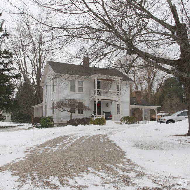
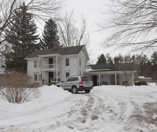
Property Record
599 Sheffield Pln, Sheffield, MA 01257

NEARBY LISTINGS FOR SALE OR LEASE
-
-
View all Sheffield listings for sale on LoopNet.com
Property Detail
599 Sheffield Pln
Pittsfield, MA
Berkshire
SHEF-000310-000002-000230
Massachusetts
Commercialofficeresidentialmixeduse
23.0
2025
1 AC
2025
Massachusetts North/West Area
926100
Other Market Areas
2,181 SF
DEMOGRAPHICS near 599 Sheffield Pln
1 Mile
3 Mile
5 Mile
2024 Total Population
328
1,720
5,254
2029 Population
307
1,637
5,104
Pop Growth 2024-2029
(6.40%)
(4.83%)
(2.85%)
Average Age
50
49
49
2024 Total Households
159
780
2,377
HH Growth 2024-2029
(6.92%)
(5.13%)
(2.90%)
Median Household Inc
$64,772
$69,595
$62,887
Avg Household Size
2.10
2.20
2.10
2024 Avg HH Vehicles
2.00
2.00
2.00
Median Home Value
$474,999
$385,060
$387,951
Median Year Built
1948
1949
1963
Nearby Places
Map Layers
Map Styles
 Street
 Aerial
- Restaurants
- Banks
- Shops
- Fitness
- Groceries
Nearby Properties
Address
Land Use
TOTAL SIZE
Lot Size
Zoning
Address
Land Use
TOTAL SIZE
Lot Size
Zoning
190,834 SF
85 AC
R1
Address
Land Use
TOTAL SIZE
Lot Size
Zoning
14,853 SF
4.57 AC
VC
Address
Land Use
TOTAL SIZE
Lot Size
Zoning
5,939 SF
5.13 AC
VC
Address
Land Use
TOTAL SIZE
Lot Size
Zoning
11,262 SF
0.23 AC
VC
Address
Land Use
TOTAL SIZE
Lot Size
Zoning
11,347 SF
41.14 AC
R1
Address
Land Use
TOTAL SIZE
Lot Size
Zoning
7,590 SF
6.06 AC
R1
Address
Land Use
TOTAL SIZE
Lot Size
Zoning
5,648 SF
19.30 AC
R1
Address
Land Use
TOTAL SIZE
Lot Size
Zoning
84,380 SF
7.50 AC
VC
Address
Land Use
TOTAL SIZE
Lot Size
Zoning
2,139 SF
62 AC
R1
Address
Land Use
TOTAL SIZE
Lot Size
Zoning
12,520 SF
3.88 AC
GB
Address
Land Use
TOTAL SIZE
Lot Size
Zoning
3,973 SF
0.75 AC
VC
Address
Land Use
TOTAL SIZE
Lot Size
Zoning
1,383 SF
16.06 AC
R1
Address
Land Use
TOTAL SIZE
Lot Size
Zoning
2,812 SF
2.50 AC
R1
Address
Land Use
TOTAL SIZE
Lot Size
Zoning
1,926 SF
135 AC
R1
Address
Land Use
TOTAL SIZE
Lot Size
Zoning
3,053 SF
14.59 AC
R1
Address
Land Use
TOTAL SIZE
Lot Size
Zoning
6,918 SF
0.88 AC
VC
Address
Land Use
TOTAL SIZE
Lot Size
Zoning
5,440 SF
0.51 AC
VC
Address
Land Use
TOTAL SIZE
Lot Size
Zoning
3,966 SF
3 AC
VC
Address
Land Use
TOTAL SIZE
Lot Size
Zoning
4,896 SF
73.78 AC
R1
Address
Land Use
TOTAL SIZE
Lot Size
Zoning
49,005 SF
2.64 AC
C
Address
Land Use
TOTAL SIZE
Lot Size
Zoning
41,155 SF
4 AC
R1
Address
Land Use
TOTAL SIZE
Lot Size
Zoning
4,902 SF
0.61 AC
VC
Address
Land Use
TOTAL SIZE
Lot Size
Zoning
26,100 SF
2.20 AC
C
Address
Land Use
TOTAL SIZE
Lot Size
Zoning
3,416 SF
26 AC
R1
Address
Land Use
TOTAL SIZE
Lot Size
Zoning
6,000 SF
10 AC
GB
Address
Land Use
TOTAL SIZE
Lot Size
Zoning
14,138 SF
5.93 AC
GB
Address
Land Use
TOTAL SIZE
Lot Size
Zoning
199 AC
R1
Address
Land Use
TOTAL SIZE
Lot Size
Zoning
2,402 SF
90.45 AC
R1
Address
Land Use
TOTAL SIZE
Lot Size
Zoning
9,100 SF
1.70 AC
C
Address
Land Use
TOTAL SIZE
Lot Size
Zoning
920 SF
7.91 AC
GB
The World's #1 Commercial Real Estate Marketplace
Connect with us
© 2025 CoStar Group
The information above has been obtained from sources believed reliable. While we do not doubt its accuracy we have not verified it and make no guarantee, warranty or representation about it. It is your responsibility to independently confirm its accuracy and completeness. Any projections, opinions, assumptions, or estimates used are for example only and do not represent the current or future performance of the property. The value of this transaction to you depends on tax and other factors which should be evaluated by your tax, financial, and legal advisors. You and your advisors should conduct a careful, independent investigation of the property to determine to your satisfaction the suitability of the property for your needs.