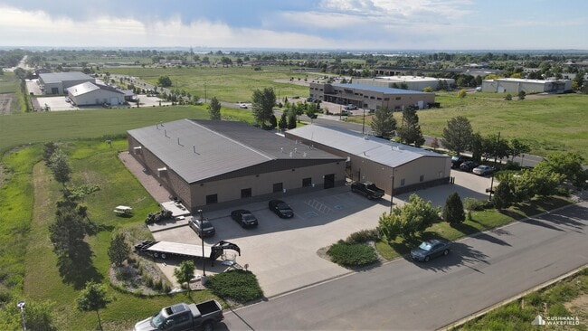
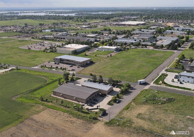
Property Record
599 W 71St St, Loveland, CO 80538

Current Lease Availabilities
Property Detail
599 W 71St St
96261-24-001
LOT 1, BLOCK 6, LONGVIEW-MIDWAY FOURTH ADDITION, LOV (87005726) AND RATIFICATION OF PLAT (97065038)
Warehouse
Larimer
I
Colorado
B and X Area of moderate flood hazard, usually the area between the limits of the 100-year and 500-year floods.
1
2024
1.64 AC
2025
Fort Collins/Loveland
001813
Denver
14,130 SF
Fort Collins-Loveland, CO
NEARBY LISTINGS FOR SALE OR LEASE
DEMOGRAPHICS near 599 W 71St St
1 mile
3 mile
5 mile
2025 Total Population
1,723
38,410
106,610
2030 Population
1,819
39,462
109,343
Pop Growth 2025-2030
+ 5.57%
+ 2.74%
+ 2.56%
Average Age
42
42
42
2025 Total Households
686
15,041
43,526
HH Growth 2025-2030
+ 5.83%
+ 2.85%
+ 2.69%
Median Household Inc
$62,083
$96,850
$94,058
Avg Household Size
2.50
2.50
2.40
2025 Avg HH Vehicles
2.00
2.00
2.00
Median Home Value
$679,347
$515,140
$573,650
Median Year Built
2008
1997
1994
Nearby Places
Map Layers
Map Styles
 Street
 Aerial
Transit
 Traffic
 Biking
Places
Listings with unknown addresses are not visible on the map
- Restaurants
- Banks
- Shops
- Fitness
- Groceries
Nearby Properties
Address
Land Use
TOTAL SIZE
Lot Size
Zoning
Address
Land Use
TOTAL SIZE
Lot Size
Zoning
573.74 AC
FA1
Address
Land Use
TOTAL SIZE
Lot Size
Zoning
117,434 SF
29.34 AC
R1
Address
Land Use
TOTAL SIZE
Lot Size
Zoning
1,440 SF
120.01 AC
I1
Address
Land Use
TOTAL SIZE
Lot Size
Zoning
222,636 SF
26.89 AC
P65
Address
Land Use
TOTAL SIZE
Lot Size
Zoning
67,144 SF
39.41 AC
Address
Land Use
TOTAL SIZE
Lot Size
Zoning
109,911 SF
6.74 AC
Address
Land Use
TOTAL SIZE
Lot Size
Zoning
117,157 SF
117.61 AC
Address
Land Use
TOTAL SIZE
Lot Size
Zoning
123,130 SF
4.17 AC
Address
Land Use
TOTAL SIZE
Lot Size
Zoning
55,831 SF
6.69 AC
Address
Land Use
TOTAL SIZE
Lot Size
Zoning
162,703 SF
14.92 AC
B
Address
Land Use
TOTAL SIZE
Lot Size
Zoning
117,496 SF
6.24 AC
Address
Land Use
TOTAL SIZE
Lot Size
Zoning
332,645 SF
14.16 AC
BUD
Address
Land Use
TOTAL SIZE
Lot Size
Zoning
125,250 SF
9.55 AC
P93
Address
Land Use
TOTAL SIZE
Lot Size
Zoning
87,518 SF
8.02 AC
Address
Land Use
TOTAL SIZE
Lot Size
Zoning
107,271 SF
3.30 AC
Address
Land Use
TOTAL SIZE
Lot Size
Zoning
82,749 SF
25.54 AC
R2
Address
Land Use
TOTAL SIZE
Lot Size
Zoning
97,225 SF
4.60 AC
P55
Address
Land Use
TOTAL SIZE
Lot Size
Zoning
80,156 SF
16 AC
FA
Address
Land Use
TOTAL SIZE
Lot Size
Zoning
41,580 SF
1.83 AC
B
Address
Land Use
TOTAL SIZE
Lot Size
Zoning
56,724 SF
9.11 AC
Address
Land Use
TOTAL SIZE
Lot Size
Zoning
387,075 SF
17.61 AC
Address
Land Use
TOTAL SIZE
Lot Size
Zoning
48,000 SF
10 AC
P58
Address
Land Use
TOTAL SIZE
Lot Size
Zoning
54,300 SF
4.05 AC
FA1
Address
Land Use
TOTAL SIZE
Lot Size
Zoning
56,876 SF
3.85 AC
R3
Address
Land Use
TOTAL SIZE
Lot Size
Zoning
54,950 SF
12.37 AC
P73
Address
Land Use
TOTAL SIZE
Lot Size
Zoning
1 SF
4.42 AC
I
Address
Land Use
TOTAL SIZE
Lot Size
Zoning
164,619 SF
11.54 AC
Address
Land Use
TOTAL SIZE
Lot Size
Zoning
71,082 SF
6.32 AC
Address
Land Use
TOTAL SIZE
Lot Size
Zoning
51,000 SF
4.21 AC
I
Address
Land Use
TOTAL SIZE
Lot Size
Zoning
55,598 SF
5 AC
R3E
The World's #1 Commercial Real Estate Marketplace
Connect with us
© 2026 CoStar Group
The information above has been obtained from sources believed reliable. While we do not doubt its accuracy we have not verified it and make no guarantee, warranty or representation about it. It is your responsibility to independently confirm its accuracy and completeness. Any projections, opinions, assumptions, or estimates used are for example only and do not represent the current or future performance of the property. The value of this transaction to you depends on tax and other factors which should be evaluated by your tax, financial, and legal advisors. You and your advisors should conduct a careful, independent investigation of the property to determine to your satisfaction the suitability of the property for your needs.