Property Record
5994 Us Highway 59 S, Texarkana, TX 75501

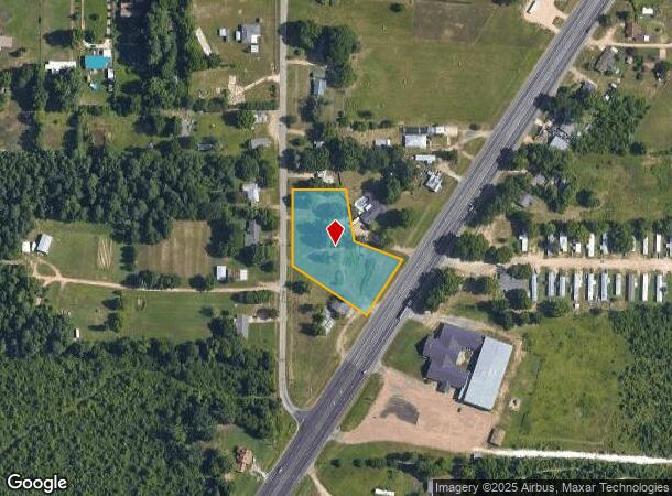
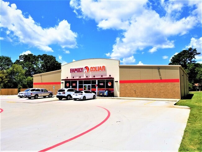
This Property Is For Sale
NEARBY LISTINGS FOR SALE OR LEASE
-
-
View all Texarkana listings for sale on LoopNet.com
Property Detail
5994 Us Highway 59 S
11760007600
M H Janes A-304
Commercialnec
M H JANES A-304 93 2020-13108 11/30/20 BLK/TRACT 92A 1.605 ACRES
X
Bowie
48067C0150C
Texas
2024
1.61 AC
2025
Texas East Area
011101
Other Market Areas
3,520 SF
Texarkana, TX-AR
DEMOGRAPHICS near 5994 Us Highway 59 S
1 Mile
3 Mile
5 Mile
2024 Total Population
1,126
10,151
29,978
2029 Population
1,114
10,160
29,922
Pop Growth 2024-2029
(1.07%)
+ 0.09%
(0.19%)
Average Age
41
41
39
2024 Total Households
462
3,711
11,608
HH Growth 2024-2029
(1.30%)
+ 0.05%
(0.22%)
Median Household Inc
$57,597
$51,222
$47,717
Avg Household Size
2.40
2.40
2.40
2024 Avg HH Vehicles
2.00
2.00
2.00
Median Home Value
$158,394
$133,200
$132,543
Median Year Built
1976
1987
1984
Nearby Places
Map Layers
Map Styles
 Street
 Aerial
- Restaurants
- Banks
- Shops
- Fitness
- Groceries
PUBLIC TRANSPORTATION
COMMUTER RAIL
Texarkana Amtrak Station (Texas Eagle - Amtrak)
DRIVE
WALK
Distance
Texarkana Amtrak Station (Texas Eagle - Amtrak)
10 min
6.6 mi
AIRPORT
Texarkana Regional-Webb Field
DRIVE
WALK
Distance
Texarkana Regional-Webb Field
20 min
12.5 mi
Freight Ports
Port of Shreveport
DRIVE
WALK
Distance
Port of Shreveport
109 min
95.9 mi
Nearby Properties
Address
Land Use
TOTAL SIZE
Lot Size
Zoning
Address
Land Use
TOTAL SIZE
Lot Size
Zoning
Address
Land Use
TOTAL SIZE
Lot Size
Zoning
19,189 SF
Address
Land Use
TOTAL SIZE
Lot Size
Zoning
43,718 SF
3.42 AC
Address
Land Use
TOTAL SIZE
Lot Size
Zoning
66,942 SF
5.91 AC
Address
Land Use
TOTAL SIZE
Lot Size
Zoning
36,562 SF
14.01 AC
Address
Land Use
TOTAL SIZE
Lot Size
Zoning
2,583 SF
75.09 AC
Address
Land Use
TOTAL SIZE
Lot Size
Zoning
131,465 SF
5.50 AC
Address
Land Use
TOTAL SIZE
Lot Size
Zoning
37,316 SF
7.34 AC
Address
Land Use
TOTAL SIZE
Lot Size
Zoning
149,326 SF
23.46 AC
Address
Land Use
TOTAL SIZE
Lot Size
Zoning
8,040 SF
8.76 AC
Address
Land Use
TOTAL SIZE
Lot Size
Zoning
32,260 SF
4.98 AC
Address
Land Use
TOTAL SIZE
Lot Size
Zoning
153,536 SF
10 AC
Address
Land Use
TOTAL SIZE
Lot Size
Zoning
139,295 SF
12.39 AC
Address
Land Use
TOTAL SIZE
Lot Size
Zoning
3,720 SF
46.12 AC
Address
Land Use
TOTAL SIZE
Lot Size
Zoning
61,920 SF
3.46 AC
Address
Land Use
TOTAL SIZE
Lot Size
Zoning
130,288 SF
16.05 AC
Address
Land Use
TOTAL SIZE
Lot Size
Zoning
24,774 SF
2.93 AC
Address
Land Use
TOTAL SIZE
Lot Size
Zoning
14,813 SF
4.39 AC
Address
Land Use
TOTAL SIZE
Lot Size
Zoning
52,224 SF
5.11 AC
Address
Land Use
TOTAL SIZE
Lot Size
Zoning
12,720 SF
4 AC
Address
Land Use
TOTAL SIZE
Lot Size
Zoning
15,680 SF
2 AC
Address
Land Use
TOTAL SIZE
Lot Size
Zoning
12,704 SF
1.58 AC
Address
Land Use
TOTAL SIZE
Lot Size
Zoning
17,484 SF
3.02 AC
Address
Land Use
TOTAL SIZE
Lot Size
Zoning
3,416 SF
4.22 AC
Address
Land Use
TOTAL SIZE
Lot Size
Zoning
44,560 SF
7.16 AC
Address
Land Use
TOTAL SIZE
Lot Size
Zoning
3,249 SF
2.20 AC
Address
Land Use
TOTAL SIZE
Lot Size
Zoning
1,200 SF
16.97 AC
Address
Land Use
TOTAL SIZE
Lot Size
Zoning
41,299 SF
4.32 AC
Address
Land Use
TOTAL SIZE
Lot Size
Zoning
9,960 SF
1.84 AC
Address
Land Use
TOTAL SIZE
Lot Size
Zoning
37,380 SF
3.14 AC
The World's #1 Commercial Real Estate Marketplace
Connect with us
© 2026 CoStar Group
The information above has been obtained from sources believed reliable. While we do not doubt its accuracy we have not verified it and make no guarantee, warranty or representation about it. It is your responsibility to independently confirm its accuracy and completeness. Any projections, opinions, assumptions, or estimates used are for example only and do not represent the current or future performance of the property. The value of this transaction to you depends on tax and other factors which should be evaluated by your tax, financial, and legal advisors. You and your advisors should conduct a careful, independent investigation of the property to determine to your satisfaction the suitability of the property for your needs.